Difference between revisions of "2012-03-28 50 8"
imported>Telegnom (→Location) |
imported>FippeBot m (Location) |
||
| (17 intermediate revisions by 3 users not shown) | |||
| Line 4: | Line 4: | ||
| date=2012-03-28 | | date=2012-03-28 | ||
}} | }} | ||
| − | |||
| − | |||
__NOTOC__ | __NOTOC__ | ||
== Location == | == Location == | ||
| − | |||
Somewhere in the woods on the hillside of the "Großer Feldberg" which is the highest mountain in the hills of the Taunus. | Somewhere in the woods on the hillside of the "Großer Feldberg" which is the highest mountain in the hills of the Taunus. | ||
== Participants == | == Participants == | ||
| − | + | * [[User:M|M]] | |
| − | * [[User: | ||
* [[User:LadyBB|LadyBB]] | * [[User:LadyBB|LadyBB]] | ||
| + | * [[User:EmmJay|EmmJay]] | ||
* [[User:Telegnom|telegnom]] | * [[User:Telegnom|telegnom]] | ||
| + | * [[User:Draradech|Draradech]] | ||
== Plans == | == Plans == | ||
| − | + | [[User:Draradech|Draradech]], [[User:Telegnom|telegnom]] trying to be there around 17:00 maybe meeting [[User:LadyBB|LadyBB]], [[User:M|M]]? | |
| − | [[User:Draradech|Draradech]], [[User:Telegnom| | ||
| − | maybe meeting [[User:LadyBB|LadyBB]], [[User:M|M]]? | ||
== Expedition == | == Expedition == | ||
| − | + | === Draradech === | |
| + | I parked my car in Oberreifenberg because I thought it would be a good idea to get some exercise and go by bike from there. As it turns out it was a bit too steep for my taste (only up, down is where the fun is), so I arrived late at the hashpoint. We had a very nice meeting and took some photos. On the way back I drove the other way round the peak. | ||
| + | |||
| + | === telegnom === | ||
| + | I parked my car at the "Große Kurve" aka. "Applauskurve". From there I hiked to the the hash location partly across country aright through the woods. I arrived in time at the location and met LadyBB, EmmJay and M. Draradech later met us. | ||
| + | |||
| + | === LadyBB & M === | ||
| + | We met around three for a pre-hash coffee and took our time as to not be too early at the hash (after chatting with Draradech). Took the car to one of the many parking lots next to one of the walking tracks leading close to the hash - a lovely track through the beautiful Taunus forest with brilliant and sunny weather. On the way there, we took the direct route and for the last 150 meters entered the woods on a steep slope (you can guess how steep it was from looking at the photos). | ||
| − | + | We actually arrived at the hash just as planned arond 5pm pretty much at the same time with [[User:telegnom|telegnom]] coming up the hill. We waited for 15 to 20 minutes until eventually [[User:Draradech|Draradech]] came down the mountain on his bike. We talked for a bit and headed back to the car on a different route in order to extend our walk for a little longer. | |
| − | |||
== Photos == | == Photos == | ||
| − | < | + | === telegnom === |
| − | Image: | + | <gallery> |
| − | --> | + | Image:2012 03 28-track-telegnom.png|my tracklog |
| − | <gallery | + | Image:20120328-navi.jpg|photo of my gps, taken at the geohash |
| + | File:Telegnom-2012-03-28-collapsed_perch.jpg|A collapsed perch somewhere near the geohash | ||
| + | </gallery> | ||
| + | |||
| + | === Draradech === | ||
| + | <gallery> | ||
| + | Image:Draradech_2012-03-28_50_8_track.png | ||
| + | Image:Draradech_2012-03-28_50_8_screen.png | ||
| + | </gallery> | ||
| + | |||
| + | === LadyBB & M === | ||
| + | <gallery> | ||
| + | Image:2012-03-28_50_8_the_way_there_1.jpg | ||
| + | Image:2012-03-28_50_8_the_way_there_2.jpg | ||
| + | Image:2012-03-28_50_8_gps_dance.jpg | GPS dancing ... | ||
| + | Image:2012-03-28_50_8_coords_reached.jpg | Coordinates reached. | ||
| + | Image:2012-03-28_50_8_group_grin.jpg | Group grin. | ||
</gallery> | </gallery> | ||
== Achievements == | == Achievements == | ||
{{#vardefine:ribbonwidth|800px}} | {{#vardefine:ribbonwidth|800px}} | ||
| − | + | {{Meet-up | latitude = 50 | longitude = 8 | date = 2012-03-28 | name = [[User:M|M]], [[User:LadyBB|LadyBB]] and [[User:EmmJay|EmmJay]] | other = [[User:Telegnom|telegnom]] and [[User:Draradech|Draradech]]}} | |
| + | {{Meet-up | latitude = 50 | longitude = 8 | date = 2012-03-28 | name = [[User:Telegnom|telegnom]] and [[User:Draradech|Draradech]] | other = [[User:M|M]], [[User:LadyBB|LadyBB]] and [[User:EmmJay|EmmJay]]}} | ||
| + | {{land geohash | latitude = 50 | longitude = 8 | date = 2012-03-28 | name = telegnom | image = 20120328-navi.jpg }} | ||
| − | |||
| − | |||
| − | |||
| − | |||
| − | |||
| − | |||
| − | |||
| − | |||
| − | |||
| − | |||
| − | |||
[[Category:Expeditions]] | [[Category:Expeditions]] | ||
| − | |||
[[Category:Expeditions with photos]] | [[Category:Expeditions with photos]] | ||
| − | |||
| − | |||
| − | |||
| − | |||
| − | |||
[[Category:Coordinates reached]] | [[Category:Coordinates reached]] | ||
| − | + | {{location|DE|HE|HG}} | |
| − | |||
| − | |||
| − | |||
| − | |||
| − | |||
| − | |||
| − | |||
| − | |||
| − | |||
Latest revision as of 03:13, 13 August 2019
| Wed 28 Mar 2012 in 50,8: 50.2292002, 8.4668425 geohashing.info google osm bing/os kml crox |
Location
Somewhere in the woods on the hillside of the "Großer Feldberg" which is the highest mountain in the hills of the Taunus.
Participants
Plans
Draradech, telegnom trying to be there around 17:00 maybe meeting LadyBB, M?
Expedition
Draradech
I parked my car in Oberreifenberg because I thought it would be a good idea to get some exercise and go by bike from there. As it turns out it was a bit too steep for my taste (only up, down is where the fun is), so I arrived late at the hashpoint. We had a very nice meeting and took some photos. On the way back I drove the other way round the peak.
telegnom
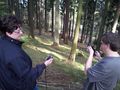
I parked my car at the "Große Kurve" aka. "Applauskurve". From there I hiked to the the hash location partly across country aright through the woods. I arrived in time at the location and met LadyBB, EmmJay and M. Draradech later met us.
LadyBB & M
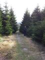
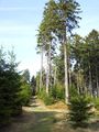
We met around three for a pre-hash coffee and took our time as to not be too early at the hash (after chatting with Draradech). Took the car to one of the many parking lots next to one of the walking tracks leading close to the hash - a lovely track through the beautiful Taunus forest with brilliant and sunny weather. On the way there, we took the direct route and for the last 150 meters entered the woods on a steep slope (you can guess how steep it was from looking at the photos).
We actually arrived at the hash just as planned arond 5pm pretty much at the same time with telegnom coming up the hill. We waited for 15 to 20 minutes until eventually Draradech came down the mountain on his bike. We talked for a bit and headed back to the car on a different route in order to extend our walk for a little longer.
Photos
telegnom
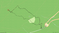
my tracklog
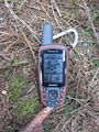
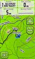
photo of my gps, taken at the geohash
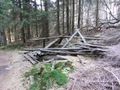
A collapsed perch somewhere near the geohash


Draradech


LadyBB & M
GPS dancing ...
Coordinates reached.
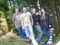
Group grin.


Achievements
M, LadyBB and EmmJay earned the Meet-up achievement
|
telegnom and Draradech earned the Meet-up achievement
|
telegnom earned the Land geohash achievement
|