Difference between revisions of "2012-04-19 37 -4"
imported>Jiml m (Fix formatting) |
imported>FippeBot m (Location) |
||
| Line 60: | Line 60: | ||
[[Category:Expeditions with photos]] | [[Category:Expeditions with photos]] | ||
[[Category:Coordinates reached]] | [[Category:Coordinates reached]] | ||
| + | {{location|ES|AN|J}} | ||
Revision as of 00:25, 6 August 2019
| Thu 19 Apr 2012 in 37,-4: 37.9705298, -4.2126209 geohashing.info google osm bing/os kml crox |
Location
In an olive grove near Lopera, Spain.
Participants
- Kydlt and his
- son/navigator/non-hasher, jgt.
Plans
I was in Spain having an adventure with my eldest. It involved driving from Barcelona up to the Atlantic coast, and then south to the Med coast, and back to Madrid. So many opportunities might present themselves.
Expedition
The 19th was a drive day, from Granada in the heart on Andalucia to Cordova. The hash was on the way, if we went that way. It was South of E-5, near a place named Lopera. Olive groves for Km in all directions. Easy walking between the trees. A sign seemed to say that the area was open for hunting, so I guess hashing was OK too.
We were challenged by lack of mapping, and lack of my trusty PN-20 GPS. So we were using the ipad GPS with the Spain NavMii app for our driving guidance. It suffers from open source maps that are not particularly good (for Spain, anyway). And Motion X's GPS HD for walking adventures. It can download Bing or Goggle maps and/or imagery, but needs a WiFi connection. often missing. Also loaded on the ipad was Hunter Researches Theodolite, which geotags photos. when I remember to turn it on.
Photos
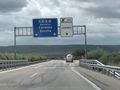
Taking the 346 Km exit off of A-4.
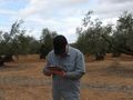
JGT following the arrow.
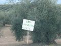
I think it says 'hunting allowed' so geohash hunting must be cool too.
I am sure that there is a better photo somewhere. Will post when found.
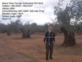
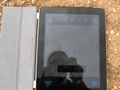
Here is one. This app only shows 4 digits to the right. The hash is actually in the middle of a tree.
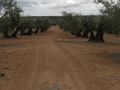
The car out at the edge of the grove. I didn't feel right driving on their tractor lanes.


Achievements
kydlt earned the Land geohash achievement
|
Template:Virgin graticule If we were not the first in this graticule will someone please point that out.