Difference between revisions of "2012-04-23 48 11"
imported>Chrisp (Created page with "<!-- If you did not specify these parameters in the template, please substitute appropriate values for IMAGE, LAT, LON, and DATE (YYYY-MM-DD format) [[Image:{{{image|IMAGE}}}|t...") |
(No difference)
|
Revision as of 19:43, 23 April 2012
| Mon 23 Apr 2012 in 48,11: 48.3673815, 11.4975338 geohashing.info google osm bing/os kml crox |
Location
On a field way near some smaller bavarian villages.
Participants
Expedition
At the university I realized how near the day's hashpoint is. So I took my bike and rode directly form university to the hash: beautiful landscape, beautiful weather. It didn't look that far away on google maps, and actually it wasn't. But what I couldn't see was the altitude differences: the bike trip was exhausting! But it turned out to be fun :)
Only a couple of kilometers from the university, and I was in a completely rural area, farm and fields everywhere. Not a single farm animal I haven't seen on this day...
The hashpoint itself was actually quite easy to reach. It seemed to be in a field, but was actually right on a small pathway. I would love to show a photographic proof, but taking a picture of my phone screen with GPS coordinates is quite impossible :/
Photos
Typical sight during the trip - including the smell ;)
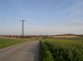
One can also see the Alpes by looking really closely!
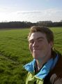
See how happy I was to have reached the hashpoint?
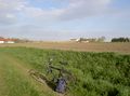
And my bike was happy too...
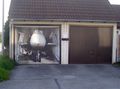
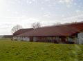
Look what they have here, just standing around in the garage


Achievements
- Land Geohash
- Bike Geohash