Difference between revisions of "2012-04-25 50 8"
From Geohashing
imported>LadyBB (Participants and Plans) |
imported>Mampfred |
||
| Line 5: | Line 5: | ||
}} | }} | ||
| − | |||
__NOTOC__ | __NOTOC__ | ||
== Location == | == Location == | ||
| Line 11: | Line 10: | ||
== Participants == | == Participants == | ||
| − | |||
| − | |||
* [[User:LadyBB|LadyBB]] and [[User:EmmJay|EmmJay]] | * [[User:LadyBB|LadyBB]] and [[User:EmmJay|EmmJay]] | ||
== Plans == | == Plans == | ||
| − | |||
In the afternoon, by foot if the weather is fine enough... Otherwise driving to residental area "Wildpark" and walking the rest of the way into the woods. | In the afternoon, by foot if the weather is fine enough... Otherwise driving to residental area "Wildpark" and walking the rest of the way into the woods. | ||
== Expedition == | == Expedition == | ||
| − | + | They made it :) - [[User:Mampfred|Mampfred]] 03:38, 26 April 2012 (EDT) | |
== Tracklog == | == Tracklog == | ||
| − | + | - | |
== Photos == | == Photos == | ||
| − | |||
| − | |||
| − | |||
<gallery perrow="5"> | <gallery perrow="5"> | ||
| + | Image:2012-04-25_50_8_coords_reached.jpg | Coordinates reached. | ||
| + | Image:2012-04-25_50_8_grin.jpg | Stupid grin(tm). | ||
</gallery> | </gallery> | ||
== Achievements == | == Achievements == | ||
{{#vardefine:ribbonwidth|800px}} | {{#vardefine:ribbonwidth|800px}} | ||
| − | |||
| − | |||
| − | |||
| − | |||
| − | |||
[[Category:Expeditions]] | [[Category:Expeditions]] | ||
| − | |||
[[Category:Expeditions with photos]] | [[Category:Expeditions with photos]] | ||
| − | |||
| − | |||
| − | |||
| − | |||
| − | |||
[[Category:Coordinates reached]] | [[Category:Coordinates reached]] | ||
| − | |||
| − | |||
| − | |||
| − | |||
| − | |||
| − | |||
| − | |||
| − | |||
| − | |||
| − | |||
Revision as of 07:38, 26 April 2012
| Wed 25 Apr 2012 in 50,8: 50.1620361, 8.2516992 geohashing.info google osm bing/os kml crox |
Location
In the woods not far from where a bunch of hashers live. Who'll make it first? :D
Participants
Plans
In the afternoon, by foot if the weather is fine enough... Otherwise driving to residental area "Wildpark" and walking the rest of the way into the woods.
Expedition
They made it :) - Mampfred 03:38, 26 April 2012 (EDT)
Tracklog
-
Photos
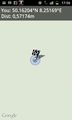
Coordinates reached.
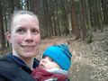
Stupid grin(tm).

