Difference between revisions of "2012-04-24 33 -84"
From Geohashing
imported>NWoodruff (Created page with "{{meetup graticule | map=<map lat="33" lon="-84" date="2012-04-24" /> | lat=33 | lon=-84 | date=2012-04-24 | graticule_name=Atlanta | graticule_link=Atlanta, Georgia }} == Grat...") |
imported>NWoodruff (→Gallery) |
||
| Line 22: | Line 22: | ||
== Gallery == | == Gallery == | ||
<gallery perrow="3"> | <gallery perrow="3"> | ||
| − | Image:2012042433-84NW01.JPG | | + | Image:2012042433-84NW01.JPG | 0.00 feet to go. The exact spot. |
| + | Image:2012042433-84NW02.JPG | Time of the meetup. | ||
| + | Image:2012042433-84NW03.JPG | Date of the meetup. | ||
| + | Image:2012042433-84NW04.JPG | 12 feet accuracy. Good enough. | ||
| + | Image:2012042433-84NW05.JPG | The bridge crossing the Flint River standing on the Geohash spot. | ||
| + | Image:2012042433-84NW06.JPG | The path that I took to get to the Geohash Spot. | ||
| + | Image:2012042433-84NW07.JPG | Me with a Stupid Grin™ standing on the Geohash spot. | ||
</gallery> | </gallery> | ||
Revision as of 16:12, 14 May 2012
| Tue 24 Apr 2012 in Atlanta: 33.5183560, -84.3784160 geohashing.info google osm bing/os kml crox |
Graticule
About
Right next to the Flint River in Jonesboro.
Expedition
NWoodruff
Gallery
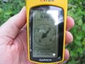
0.00 feet to go. The exact spot.
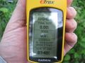
Time of the meetup.
Date of the meetup.
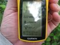
12 feet accuracy. Good enough.
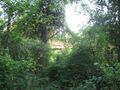
The bridge crossing the Flint River standing on the Geohash spot.
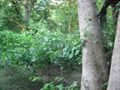
The path that I took to get to the Geohash Spot.

Me with a Stupid Grin™ standing on the Geohash spot.


