Difference between revisions of "2012-05-03 60 22"
imported>Suurnesu m |
imported>FippeBot m (Location) |
||
| (2 intermediate revisions by 2 users not shown) | |||
| Line 9: | Line 9: | ||
}} | }} | ||
| − | + | ||
__NOTOC__ | __NOTOC__ | ||
== Location == | == Location == | ||
| − | + | ||
In Turku, near Lauste suburb | In Turku, near Lauste suburb | ||
== Participants == | == Participants == | ||
| − | + | ||
| − | + | * [[User:nsk|nsk]] | |
| − | [[User:Suurnesu|Suurnesu]] | + | * [[User:Suurnesu|Suurnesu]] |
== Expedition == | == Expedition == | ||
| − | + | ||
| + | Hash was so easily accessed just about 3.5 kilometers from my home so I cycled there on the morning before going to work. Nothing special at the area, just some traffic, grass, sidewalk... I had to walk a while in the grass before my GPSr showed the exactly correct coordinates but soon they appeared and I got the desired photo. And then I continued to work. Nice and easy geohash this time. | ||
| + | |||
| + | -nsk | ||
| + | |||
This hashpoint was again quite close to my home so I decided to go for it and maybe do some geocaching at the same time. | This hashpoint was again quite close to my home so I decided to go for it and maybe do some geocaching at the same time. | ||
| − | I left my car close to a football field and walked some 150 meters to the zeropoint. There were some innocent people passing by without knowing that there was something very special about that place! Indeed, my GPS showed the 0-point to be right in the middle of | + | I left my car close to a football field and walked some 150 meters to the zeropoint. There were some innocent people passing by without knowing that there was something very special about that place! Indeed, my GPS showed the 0-point to be right in the middle of a cycleway! No bushwhacking whatsoever! What a joy! I took some pictures and left with a smile on my face! :) |
| − | a cycleway! No bushwhacking whatsoever! What a joy! I took some pictures and left with a smile on my face! :) | + | |
| + | -Suurnesu | ||
== Photos == | == Photos == | ||
| − | + | ||
| − | |||
| − | |||
<gallery perrow="5"> | <gallery perrow="5"> | ||
Image:2012_05_03_60_22_happy.jpg | I was so happy that I could make it again! | Image:2012_05_03_60_22_happy.jpg | I was so happy that I could make it again! | ||
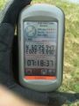
Image:2012_05_03_60_22_GPS.jpg | GPS at the 0-point | Image:2012_05_03_60_22_GPS.jpg | GPS at the 0-point | ||
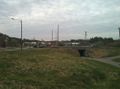
Image:2012_05_03_60_22_panorama.jpg | Impressive panorama over the area | Image:2012_05_03_60_22_panorama.jpg | Impressive panorama over the area | ||
| + | Image:2012-05-03_60_22_nsks_gps_at_the_location.jpg | nsk's GPSr at the location | ||
| + | Image:2012-05-03_60_22_hash_area.jpg | Area where the hash was | ||
</gallery> | </gallery> | ||
| Line 40: | Line 45: | ||
<!-- Add any achievement ribbons you earned below, or remove this section --> | <!-- Add any achievement ribbons you earned below, or remove this section --> | ||
| + | * Land geohash | ||
| − | |||
| − | |||
| − | |||
| − | + | [[Category:Expeditions]] | |
| − | |||
| − | [[Category: | ||
| − | |||
| − | |||
| − | |||
| − | |||
[[Category:Expeditions with photos]] | [[Category:Expeditions with photos]] | ||
| − | |||
| − | |||
| − | |||
| − | |||
| − | |||
[[Category:Coordinates reached]] | [[Category:Coordinates reached]] | ||
| − | + | {{location|FI|19}} | |
| − | |||
| − | |||
| − | |||
| − | |||
| − | |||
| − | |||
| − | |||
| − | |||
| − | |||
Latest revision as of 03:46, 13 August 2019
| Thu 3 May 2012 in 60,22: 60.4324494, 22.3331714 geohashing.info google osm bing/os kml crox |
Location
In Turku, near Lauste suburb
Participants
Expedition
Hash was so easily accessed just about 3.5 kilometers from my home so I cycled there on the morning before going to work. Nothing special at the area, just some traffic, grass, sidewalk... I had to walk a while in the grass before my GPSr showed the exactly correct coordinates but soon they appeared and I got the desired photo. And then I continued to work. Nice and easy geohash this time.
-nsk
This hashpoint was again quite close to my home so I decided to go for it and maybe do some geocaching at the same time. I left my car close to a football field and walked some 150 meters to the zeropoint. There were some innocent people passing by without knowing that there was something very special about that place! Indeed, my GPS showed the 0-point to be right in the middle of a cycleway! No bushwhacking whatsoever! What a joy! I took some pictures and left with a smile on my face! :)
-Suurnesu
Photos

I was so happy that I could make it again!

GPS at the 0-point

Impressive panorama over the area
nsk's GPSr at the location
Area where the hash was


Achievements
- Land geohash