Difference between revisions of "2012-05-07 48 9"
imported>Steingesicht (→Achievements) |
imported>Steingesicht (→Photos) |
||
| Line 36: | Line 36: | ||
== Photos == | == Photos == | ||
| − | |||
| − | |||
| − | |||
<gallery perrow="5"> | <gallery perrow="5"> | ||
| + | Image:2012 05 07 48 9 view from highway.jpeg | views to the hashpoint from the highway | ||
| + | Image:2012 05 07 48 9 surveyors at work.jpeg | surveyors at work | ||
| + | Image:2012 05 07 48 9 highway from above.jpeg | highway A8 from above | ||
| + | Image:2012 05 07 48 9 destination highway.jpeg | destination of the highway | ||
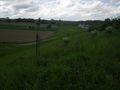
| + | Image:2012 05 07 48 9 view from hashpoint to fair.jpeg | view from hashpoint to fair | ||
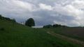
| + | Image:2012 05 07 48 9 view from hashpoint.jpeg | view from hashpoint | ||
| + | Image:2012 05 07 48 9 hashpoint from above.jpeg | hashpoint from above | ||
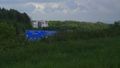
| + | Image:2012 05 07 48 9 hashproof.jpeg | hashproof | ||
</gallery> | </gallery> | ||
Revision as of 19:15, 7 May 2012
| Mon 7 May 2012 in 48,9: 48.7065556, 9.1583394 geohashing.info google osm bing/os kml crox |
Location
A sound barrier earth wall at the Echterdinger Ei. The hashpoint was really close to the highway A8 and may be the loudest hashpoint.
Participants
Steingesicht was there after work.
Plans
The expedition was really unplannend.
Expedition
I went spontaneous to this hashpoint at my way home from work - it was to close to skip. Just some meters mor to the north and it could be a drive-through ath the highway A8.
Some weeks ago I had a serious injury at my left ankle and this was my first attempt since than. So I parked my car at a track close to the hashpoint and walked the last some 100m. On my way to the hashpoint I passed two field surveyor at work - but they did not measure the hashpoint, only some minor interesting points.
Tracklog
Photos
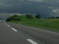
views to the hashpoint from the highway

surveyors at work
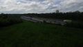
highway A8 from above
destination of the highway
view from hashpoint to fair
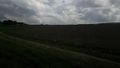
view from hashpoint
hashpoint from above
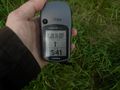
hashproof


Achievements
none yet