Difference between revisions of "2012-05-03 62 17"
imported>Penthok m (Created page with "{{subst:Expedition |lat = 62 |lon = 17 |date = 2012-05-03 }}") |
imported>FippeBot m (Location) |
||
| (2 intermediate revisions by 2 users not shown) | |||
| Line 1: | Line 1: | ||
| + | [[Image:{{{image|2012-05-03_62_17_-_P8_-_View.JPG}}}|thumb|left]] | ||
| − | |||
| − | |||
| − | |||
| − | |||
{{meetup graticule | {{meetup graticule | ||
| lat=62 | | lat=62 | ||
| Line 10: | Line 7: | ||
}} | }} | ||
| − | + | ||
__NOTOC__ | __NOTOC__ | ||
== Location == | == Location == | ||
| − | + | Hash was surveyed to be in the forest between the shopping area of Birsta and the city of Sundsvall. | |
== Participants == | == Participants == | ||
| − | + | *[[User:Penthok|Penthok]] | |
| − | |||
== Plans == | == Plans == | ||
| − | + | My plans were to go to Birsta, do a little shopping and then go to the hashpoint, followed by a visit to my sister. | |
== Expedition == | == Expedition == | ||
| − | + | I set out with the bus to reach Birsta, where I was getting off to do a little shopping before walking over to the hashpoint. After that I climbed up into the forest behind Bauhaus, getting up on top of the mountain behind it where I for some reason happened upon a park bench. I saw nothing resembling an actual path leading there so I don't really know why it even was there. Then I went downhill a little until I reached the logging grounds (again) where the hashpoint was. | |
| + | |||
| + | After doing a bit of triangulation I located the hashpoint. I then walked over to it and enjoyed the sun. I of course forgot to take a picture of myself, but at least I took a picture of the surroundings. After that I went home to my sister for a bit before going back home. | ||
== Tracklog == | == Tracklog == | ||
| − | + | No GPS, no log. | |
== Photos == | == Photos == | ||
| − | < | + | |
| − | Image: | + | <gallery perrow="4"> |
| − | -- | + | Image:2012-05-03_62_17_-_P1_-_Bus.JPG | The bus used to get myself close to the hashpoint. |
| − | + | Image:2012-05-03_62_17_-_P2_-_Bauhaus.JPG | Bauhaus at the south end of Birsta, the path towards the hashpoint starting behind it. | |
| + | Image:2012-05-03_62_17_-_P3_-_Flowers.JPG | Pretty spring flowers found on the way to the hash. Anemone nemorosa and Anemone hepatica. | ||
| + | Image:2012-05-03_62_17_-_P4_-_Parkbench.JPG | Inexplicable parkbench on mountaintop. | ||
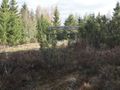
| + | Image:2012-05-03_62_17_-_P5_-_Logging Grounds.JPG | Why do all my hashpoints keep ending up on logging grounds? | ||
| + | Image:2012-05-03_62_17_-_P6_-_Hashpoint.JPG | The hashpoint, the point itself being at the fat, small tree in the middle of the picture. | ||
| + | Image:2012-05-03_62_17_-_P7_-_Map.JPG | The map at the hashpoint. | ||
| + | Image:2012-05-03_62_17_-_P8_-_View.JPG | The view from the hashpoint. | ||
</gallery> | </gallery> | ||
== Achievements == | == Achievements == | ||
{{#vardefine:ribbonwidth|800px}} | {{#vardefine:ribbonwidth|800px}} | ||
| − | |||
| + | {{land geohash | ||
| + | |||
| + | | latitude = 62 | ||
| + | | longitude = 17 | ||
| + | | date = 2012-05-03 | ||
| + | | name = Penthok | ||
| + | |||
| + | }} | ||
| + | |||
| + | {{Public transport geohash | ||
| + | |||
| + | | latitude = 62 | ||
| + | | longitude = 17 | ||
| + | | date = 2012-05-03 | ||
| + | | busline = Din Tur bus 201 | ||
| + | | name = Penthok | ||
| + | |||
| + | }} | ||
| + | |||
| + | {{No_batteries_geohash | ||
| + | |||
| + | | latitude = 62 | ||
| + | | longitude = 17 | ||
| + | | date = 2012-05-03 | ||
| + | | name = Penthok | ||
| + | |||
| + | }} | ||
| − | |||
| − | |||
| − | |||
| − | |||
| − | |||
| − | |||
| − | |||
| − | |||
[[Category:Expeditions]] | [[Category:Expeditions]] | ||
| − | |||
[[Category:Expeditions with photos]] | [[Category:Expeditions with photos]] | ||
| − | + | [[Category:Expedition without GPS]] | |
| − | [[Category:Expedition without GPS]] | ||
| − | |||
| − | |||
| − | |||
[[Category:Coordinates reached]] | [[Category:Coordinates reached]] | ||
| − | + | {{location|SE|Y}} | |
| − | |||
| − | |||
| − | |||
| − | |||
| − | |||
| − | |||
| − | |||
| − | |||
| − | |||
Latest revision as of 03:46, 13 August 2019

| Thu 3 May 2012 in 62,17: 62.4324494, 17.3331714 geohashing.info google osm bing/os kml crox |
Location
Hash was surveyed to be in the forest between the shopping area of Birsta and the city of Sundsvall.
Participants
Plans
My plans were to go to Birsta, do a little shopping and then go to the hashpoint, followed by a visit to my sister.
Expedition
I set out with the bus to reach Birsta, where I was getting off to do a little shopping before walking over to the hashpoint. After that I climbed up into the forest behind Bauhaus, getting up on top of the mountain behind it where I for some reason happened upon a park bench. I saw nothing resembling an actual path leading there so I don't really know why it even was there. Then I went downhill a little until I reached the logging grounds (again) where the hashpoint was.
After doing a bit of triangulation I located the hashpoint. I then walked over to it and enjoyed the sun. I of course forgot to take a picture of myself, but at least I took a picture of the surroundings. After that I went home to my sister for a bit before going back home.
Tracklog
No GPS, no log.
Photos
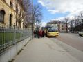
The bus used to get myself close to the hashpoint.
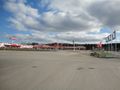
Bauhaus at the south end of Birsta, the path towards the hashpoint starting behind it.
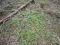
Pretty spring flowers found on the way to the hash. Anemone nemorosa and Anemone hepatica.
Inexplicable parkbench on mountaintop.
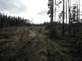
Why do all my hashpoints keep ending up on logging grounds?
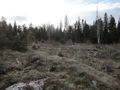
The hashpoint, the point itself being at the fat, small tree in the middle of the picture.
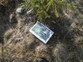
The map at the hashpoint.
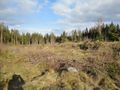
The view from the hashpoint.


Achievements
Penthok earned the Land geohash achievement
|
Penthok earned the Public transport geohash achievement
|
Penthok earned the No Batteries Geohash Achievement
|