Difference between revisions of "2012-05-15 36 -80"
imported>Birdray m |
imported>Birdray m |
||
| Line 7: | Line 7: | ||
}} | }} | ||
| − | + | ||
__NOTOC__ | __NOTOC__ | ||
== Location == | == Location == | ||
| Line 69: | Line 69: | ||
}} | }} | ||
| − | |||
| − | |||
| − | |||
| − | |||
[[Category:Expeditions]] | [[Category:Expeditions]] | ||
[[Category:Expeditions with photos]] | [[Category:Expeditions with photos]] | ||
[[Category:Coordinates reached]] | [[Category:Coordinates reached]] | ||
Revision as of 00:18, 25 November 2012

| Tue 15 May 2012 in 36,-80: 36.0962780, -80.2920972 geohashing.info google osm bing/os kml crox |
Location
Just to one side of a Y-intersection of two roads in the Country Club neighborhoods of Winston-Salem.
Participants
Birdray, who also dragged a friend (Vera), unintentionally achieving the drag-along achievement. (Mostly it was just fun to have an adventure buddy.)
Plans
I was thrilled to see that the day's hashpoint was not only within two miles of my apartment, but was also on a residential road, i.e. somewhere I could reasonably show up without having to talk my way onto someone's property. We planned to acquire a copy of the day's paper, just to have an old-school timestamp on the expedition. There was also a pre-hash nap planned in, because that's how we roll.
Expedition
I went to pick up Vera from the bookstore and we went in search of a newspaper. After finding the New York Times at Harris Teeter, we used the Android Geohashing app to map directions to the hashpoint, which was at that point about a mile away. I had my fingers crossed that my phone wouldn't die, as I had somehow fried my charger and was running on about 30% battery before I turned the GPS on. We came to the Y-intersection, parked the car, and started wandering in search of the hashpoint.
"What does it look like?" Vera asked.
"I'm not sure, we haven't found it yet!"
"Oh! It's... it's not a thing?"
"Nope, just a set of coordinates."
Vera commented on the likelihood of getting the cops called on us for wandering around cluelessly in a very affluent neighborhood. Vera had a point.
The app lit up about ten feet from the kerb, to which we promptly had to relocate when a car came along. We took pictures, in which I look like a rabid groundhog given that I'm exceptionally prone to red-eye, as it was getting dark, and then headed back to the car.
Postscript: I greatly regret not attempting the Speed Racer achievement, but as it was getting dark, we decided to hightail it out.
Postpostscript: As it looks like the planned 2010-07-31_36_-80 expedition never occurred, and Oracle989 did not reach the coordinates for the 2009-10-04_36_-80 expedition, I believe this is a virgin graticule achievement. Sebejias, LevinSerra, and Oracle989, let me know if this is not true!
Photos
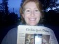
Really nothing much to see here--a dark residential area--other than my absolutely rabid red-eye, which happens in almost every photo of me. Taken by my friend Vera.

A closeup of the coordinates. Also the tell-tale "Your battery is ABOUT TO DIE A HORRIBLE DEATH" red light.

Achievements
Birdray earned the Land geohash achievement
|
Birdray earned the Drag-along achievement
|