Difference between revisions of "2012-05-30 45 -121"
imported>Kydlt (Created page with "== Location == The wilds of Skamania Co. == Participants == * kydlt == Plans == Flew in from KY to PDX early and passed over a hash (Baker City, OR) on the way...") |
imported>FippeBot m (Location) |
||
| (5 intermediate revisions by 3 users not shown) | |||
| Line 1: | Line 1: | ||
| + | {{meetup graticule | ||
| + | |lat=45 | ||
| + | |lon=-121 | ||
| + | |date=2012-05-30 | ||
| + | }} | ||
| + | |||
| + | |||
== Location == | == Location == | ||
The wilds of Skamania Co. | The wilds of Skamania Co. | ||
| Line 9: | Line 16: | ||
== Expedition == | == Expedition == | ||
| − | Short slow drive | + | Short slow drive then a uphill hike. |
| − | The hash was just off a road | + | |
| + | The hash was just off a road according Google, but up here that doesn't mean much. Driving slow in the old Honda I got to within 3/4 mile (line of sight)of the spot, but it was a mile and 3/4 each way to walk. Solo and with no cell or 2 meter coverage I elected to walk the road rather than x-country it. Also that avoided the deep gorge. A very pleasant walk with nice creek noise and no other people around. | ||
== Tracklog == | == Tracklog == | ||
| Line 16: | Line 24: | ||
== Photos == | == Photos == | ||
<gallery perrow="4"> | <gallery perrow="4"> | ||
| − | + | Image:2012-05-30 45 -121 01.JPG|The Honda only made it 7 miles and 1600 ft UP the road. | |
| + | Image:2012-05-30 45 -121 08 steep.JPG|A walk of 1.7 miles and another 500 feet UP. | ||
| + | Image:2012-05-30 45 -121 07 snow.JPG|Past one little last patch of snow. | ||
| + | Image:2012-05-30 45 -121 06 trillium.JPG|and 3 colors of trillium. | ||
| + | Image:2012-05-30 45 -121 02.JPG|To a little 6-way crossroads. | ||
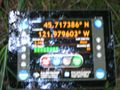
| + | Image:2012-05-30 45 -121 03 ipad.JPG|The ipad numbers wouldn't get much closer than 14 ft off. And the camera wouldn't focus on the glare. | ||
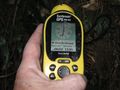
| + | Image:2012-05-30 45 -121 04 delorme.JPG|I swear the DeLorme said zero feet to go when I picked up the camera. | ||
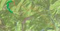
| + | Image:2012-05-30 45 -121 05 topo.JPG|A screen capture of the track. Orange for the drive, green for the walk. | ||
</gallery> | </gallery> | ||
| Line 22: | Line 37: | ||
[[Category:Expeditions with photos]] | [[Category:Expeditions with photos]] | ||
[[Category:Coordinates reached]] | [[Category:Coordinates reached]] | ||
| + | {{location|US|WA|SM}} | ||
Latest revision as of 04:18, 13 August 2019
| Wed 30 May 2012 in 45,-121: 45.7173797, -121.9796575 geohashing.info google osm bing/os kml crox |
Location
The wilds of Skamania Co.
Participants
Plans
Flew in from KY to PDX early and passed over a hash (Baker City, OR) on the way, and that got me ready to go.
Expedition
Short slow drive then a uphill hike.
The hash was just off a road according Google, but up here that doesn't mean much. Driving slow in the old Honda I got to within 3/4 mile (line of sight)of the spot, but it was a mile and 3/4 each way to walk. Solo and with no cell or 2 meter coverage I elected to walk the road rather than x-country it. Also that avoided the deep gorge. A very pleasant walk with nice creek noise and no other people around.
Tracklog
Photos
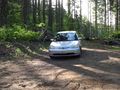
The Honda only made it 7 miles and 1600 ft UP the road.
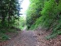
A walk of 1.7 miles and another 500 feet UP.

Past one little last patch of snow.
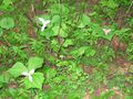
and 3 colors of trillium.
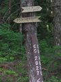
To a little 6-way crossroads.
The ipad numbers wouldn't get much closer than 14 ft off. And the camera wouldn't focus on the glare.
I swear the DeLorme said zero feet to go when I picked up the camera.
A screen capture of the track. Orange for the drive, green for the walk.


