Difference between revisions of "2012-06-05 54 10"
From Geohashing
imported>Schorhr (An expedition message sent via Geohash Droid for Android.) |
imported>FippeBot m (Location) |
||
| (5 intermediate revisions by 2 users not shown) | |||
| Line 1: | Line 1: | ||
| − | |||
<!-- If you did not specify these parameters in the template, please substitute appropriate values for IMAGE, LAT, LON, and DATE (YYYY-MM-DD format) | <!-- If you did not specify these parameters in the template, please substitute appropriate values for IMAGE, LAT, LON, and DATE (YYYY-MM-DD format) | ||
| Line 19: | Line 18: | ||
== Location == | == Location == | ||
<!-- where you've surveyed the hash to be --> | <!-- where you've surveyed the hash to be --> | ||
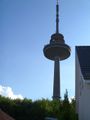
| + | At the edge of a road, right at a small parking space. Easy to reach. | ||
| + | A nice wooden road sign and the television tower visible from the spot. | ||
== Participants == | == Participants == | ||
<!-- who attended: If you link to your wiki user name in this section, your expedition will be picked up by the various statistics generated for geohashing. You may use three tildes ~ as a shortcut to automatically insert the user signature of the account you are editing with. | <!-- who attended: If you link to your wiki user name in this section, your expedition will be picked up by the various statistics generated for geohashing. You may use three tildes ~ as a shortcut to automatically insert the user signature of the account you are editing with. | ||
--> | --> | ||
| + | [[User:AE|AE]] | ||
| + | [[User:Schorhr|Schorhr]] | ||
== Plans == | == Plans == | ||
| Line 30: | Line 33: | ||
<!-- how it all turned out. your narrative goes here. --> | <!-- how it all turned out. your narrative goes here. --> | ||
| + | |||
| + | *We where there. -- [[User:Schorhr|Schorhr]] 13:05, 5 June 2012 (EDT) | ||
== Tracklog == | == Tracklog == | ||
<!-- if your GPS device keeps a log, you may post a link here --> | <!-- if your GPS device keeps a log, you may post a link here --> | ||
| Line 38: | Line 43: | ||
--> | --> | ||
<gallery perrow="5"> | <gallery perrow="5"> | ||
| + | Image:2012-06-05_54-10_0.jpg | Here we are | ||
| + | Image:2012-06-05_54-10_1.jpg | We are exposed to radiation | ||
| + | Image:2012-06-05_54-10_2.jpg | This IS a good sign | ||
| + | Image:2012-06-05_54-10_3.jpg | The digital projection of myself on the virtual map in my physical grip over the real location. | ||
| + | |||
</gallery> | </gallery> | ||
| Line 47: | Line 57: | ||
<!-- =============== USEFUL CATEGORIES FOLLOW ================ | <!-- =============== USEFUL CATEGORIES FOLLOW ================ | ||
Delete the next line ONLY if you have chosen the appropriate categories below. If you are unsure, don't worry. People will read your report and help you with the classification. --> | Delete the next line ONLY if you have chosen the appropriate categories below. If you are unsure, don't worry. People will read your report and help you with the classification. --> | ||
| − | [[Category: | + | [[Category:Expeditions]] |
| + | [[Category:Expeditions with photos]] | ||
| + | [[Category:Coordinates reached]] | ||
<!-- Potential categories. Please include all the ones appropriate to your expedition --> | <!-- Potential categories. Please include all the ones appropriate to your expedition --> | ||
| Line 74: | Line 86: | ||
[[Category:Not reached - Did not attempt]] when you went to an alternate location, or decided early on to abort the expedition. | [[Category:Not reached - Did not attempt]] when you went to an alternate location, or decided early on to abort the expedition. | ||
--> | --> | ||
| + | {{location|DE|SH|KI}} | ||
Latest revision as of 04:24, 13 August 2019
| Tue 5 Jun 2012 in 54,10: 54.3015895, 10.1208696 geohashing.info google osm bing/os kml crox |
Location
At the edge of a road, right at a small parking space. Easy to reach. A nice wooden road sign and the television tower visible from the spot.
Participants
Plans
Expedition
- We where there. -- Schorhr 13:05, 5 June 2012 (EDT)
Tracklog
Photos

Here we are
We are exposed to radiation
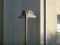
This IS a good sign
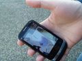
The digital projection of myself on the virtual map in my physical grip over the real location.


