Difference between revisions of "2012-06-06 32 -117"
From Geohashing
imported>Mathgeek (→Participants) |
imported>JesseW (add short write up of mine, will add pictures and more detail later) |
||
| Line 24: | Line 24: | ||
<!-- how it all turned out. your narrative goes here. --> | <!-- how it all turned out. your narrative goes here. --> | ||
| + | *Actually made this one today... Kinda hanging off a steep slope but it is a great view. -- [[User:Mathgeek|Mathgeek]] [http://www.openstreetmap.org/?lat=32.92833816&lon=-117.11174423&zoom=16&layers=B000FTF @32.9283,-117.1117] 16:34, 6 June 2012 (PDT) | ||
| − | * | + | *I also made it, just as it was getting dark (I had to use a flashlight app on my phone to see my way back.) After making it within GPS accuracy of the spot, I went downhill (more or less on my ass) to the drainage ditch partway down the slope, then walked back along it till the corner of the hill, where I (thankfully) found a (probably water-made) path that led most of the way back up. I had to fight my way through bushes for part of the way. I was glad I didn't fall off the side of the slope. Pictures to come. [[User:JesseW|JesseW]] 14:17, 7 June 2012 (EDT) |
== Tracklog == | == Tracklog == | ||
<!-- if your GPS device keeps a log, you may post a link here --> | <!-- if your GPS device keeps a log, you may post a link here --> | ||
| Line 41: | Line 42: | ||
{{#vardefine:ribbonwidth|800px}} | {{#vardefine:ribbonwidth|800px}} | ||
<!-- Add any achievement ribbons you earned below, or remove this section --> | <!-- Add any achievement ribbons you earned below, or remove this section --> | ||
| + | {{land geohash | ||
| + | | latitude = 32 | ||
| + | | longitude = -117 | ||
| + | | date = date 2012-06-06 | ||
| + | | name = [[User:JesseW|JesseW]] | ||
| + | }} | ||
| − | |||
| − | |||
| − | |||
| − | |||
[[Category:Expeditions]] | [[Category:Expeditions]] | ||
| − | |||
[[Category:Expeditions with photos]] | [[Category:Expeditions with photos]] | ||
| − | |||
| − | |||
| − | |||
| − | |||
| − | |||
[[Category:Coordinates reached]] | [[Category:Coordinates reached]] | ||
| − | |||
| − | |||
| − | |||
| − | |||
| − | |||
| − | |||
| − | |||
| − | |||
| − | |||
| − | |||
Revision as of 18:17, 7 June 2012
| Wed 6 Jun 2012 in 32,-117: 32.9283575, -117.1117727 geohashing.info google osm bing/os kml crox |
Location
Up an embankment just east of the 15, just south of Scripps Poway Pkwy; the closest road is 11518 Cortina Pl. San Diego, CA 92131
Participants
Plans
Drive up the 15, maybe stop along the side if possible. Then drive up to the housing development, and try and walk around the houses to get to the actual hashpoint. It'd be nice to meet up with other hashers, so I'll wait until Noon before deciding on a time -- please post here (and/or email me) if you are thinking of going. I'll be in a white HOnda Accord.
Expedition
- Actually made this one today... Kinda hanging off a steep slope but it is a great view. -- Mathgeek @32.9283,-117.1117 16:34, 6 June 2012 (PDT)
- I also made it, just as it was getting dark (I had to use a flashlight app on my phone to see my way back.) After making it within GPS accuracy of the spot, I went downhill (more or less on my ass) to the drainage ditch partway down the slope, then walked back along it till the corner of the hill, where I (thankfully) found a (probably water-made) path that led most of the way back up. I had to fight my way through bushes for part of the way. I was glad I didn't fall off the side of the slope. Pictures to come. JesseW 14:17, 7 June 2012 (EDT)
Tracklog
Photos
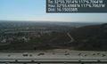
Hanging off the hillside. @32.9283,-117.1118

Achievements
JesseW earned the Land geohash achievement
|