Difference between revisions of "2012-06-09 51 12"
From Geohashing
imported>Bazaruto (→Expedition) |
imported>Bazaruto m (→Achievements) |
||
| Line 46: | Line 46: | ||
<!-- =============== USEFUL CATEGORIES FOLLOW ================ | <!-- =============== USEFUL CATEGORIES FOLLOW ================ | ||
Delete the next line ONLY if you have chosen the appropriate categories below. If you are unsure, don't worry. People will read your report and help you with the classification. --> | Delete the next line ONLY if you have chosen the appropriate categories below. If you are unsure, don't worry. People will read your report and help you with the classification. --> | ||
| − | |||
| − | |||
[[Category:Expeditions]] | [[Category:Expeditions]] | ||
Revision as of 05:37, 16 June 2012
| Sat 9 Jun 2012 in 51,12: 51.2504609, 12.4625358 geohashing.info google osm bing/os kml crox |
Location
A field of corn between Güldengossa and Störmthal.
Participants
Expedition
The hash was easy to find - its three steps off one of my favorite cycling tours (kind of Deja vu).
The tour led me across an old battlefield. Then to the new lake "Störmthaler See". And at the hashpoint I found out, I need a new software to show the coordinates on my phone ;(.
Photos
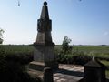
Monument of a battlefield
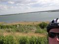
Störmthaler See

Nearly the coordinates


Achievements
Bazaruto earned the Land geohash achievement
|
Bazaruto earned the Bicycle geohash achievement
|