Difference between revisions of "2012-06-09 45 -93"
imported>ElectorCount (→Expedition) |
imported>FippeBot m (Location) |
||
| (15 intermediate revisions by one other user not shown) | |||
| Line 1: | Line 1: | ||
| − | |||
<!-- If you did not specify these parameters in the template, please substitute appropriate values for IMAGE, LAT, LON, and DATE (YYYY-MM-DD format) | <!-- If you did not specify these parameters in the template, please substitute appropriate values for IMAGE, LAT, LON, and DATE (YYYY-MM-DD format) | ||
| Line 20: | Line 19: | ||
<!-- where you've surveyed the hash to be --> | <!-- where you've surveyed the hash to be --> | ||
Located in Ramsey Minnesota, this hash was located in the middle of a wetland. | Located in Ramsey Minnesota, this hash was located in the middle of a wetland. | ||
| + | |||
| + | * 45.25046°, -93.462536° or | ||
| + | * N45°15.0276', W93°27.7521' or | ||
| + | * N45°15'1.65", W93°27'45.12" | ||
== Participants == | == Participants == | ||
<!-- who attended: If you link to your wiki user name in this section, your expedition will be picked up by the various statistics generated for geohashing. You may use three tildes ~ as a shortcut to automatically insert the user signature of the account you are editing with. | <!-- who attended: If you link to your wiki user name in this section, your expedition will be picked up by the various statistics generated for geohashing. You may use three tildes ~ as a shortcut to automatically insert the user signature of the account you are editing with. | ||
--> | --> | ||
| − | [[User:ElectorCount|ElectorCount]] | + | [[User:ElectorCount|ElectorCount]], Mason |
== Plans == | == Plans == | ||
| Line 36: | Line 39: | ||
Initially I was hesitant to go into the wetland not knowing how easily we would be able to traverse the terrain. My friend decided to take action and lead the way into the wetland and I followed behind cautiously. Slowly but surely we made our way to the location coordinates. The deeper we went into the wetland the wetter the ground got. I ended up walking the rest of the way barefoot. Finally we had reached the coordinates, mission accomplished. | Initially I was hesitant to go into the wetland not knowing how easily we would be able to traverse the terrain. My friend decided to take action and lead the way into the wetland and I followed behind cautiously. Slowly but surely we made our way to the location coordinates. The deeper we went into the wetland the wetter the ground got. I ended up walking the rest of the way barefoot. Finally we had reached the coordinates, mission accomplished. | ||
| − | == Tracklog == | + | <!-- == Tracklog == |
| − | + | if your GPS device keeps a log, you may post a link here --> | |
== Photos == | == Photos == | ||
| Line 44: | Line 47: | ||
--> | --> | ||
<gallery perrow="5"> | <gallery perrow="5"> | ||
| + | Image:2012 06 09 45 -93 coordinates.JPG | Meetup Coordinates | ||
| + | Image:2012 06 09 45 -93 winner.JPG | We have a Winner! | ||
| + | Image:2012 06 09 45 -93 feet.JPG | It got a little wet | ||
| + | Image:2012 06 09 45 -93 facingtheroad.JPG | If you squint, you can see my car | ||
| + | Image:2012 06 09 45 -93 thumbsupgrin.JPG | Thumbs Up | ||
</gallery> | </gallery> | ||
| Line 49: | Line 57: | ||
{{#vardefine:ribbonwidth|800px}} | {{#vardefine:ribbonwidth|800px}} | ||
<!-- Add any achievement ribbons you earned below, or remove this section --> | <!-- Add any achievement ribbons you earned below, or remove this section --> | ||
| + | {{land geohash | ||
| + | |||
| + | | latitude = 45 | ||
| + | | longitude = -93 | ||
| + | | date = 2012-06-09 | ||
| + | | name = [[User: ElectorCount|ElectorCount]] and Mason | ||
| + | |||
| + | }} | ||
| + | {{drag-along | ||
| + | |||
| + | | latitude = 45 | ||
| + | | longitude = -93 | ||
| + | | date = 2012-06-09 | ||
| + | | partner = Mason | ||
| + | | name = [[User: ElectorCount|ElectorCount]] | ||
| + | }} | ||
<!-- =============== USEFUL CATEGORIES FOLLOW ================ | <!-- =============== USEFUL CATEGORIES FOLLOW ================ | ||
Delete the next line ONLY if you have chosen the appropriate categories below. If you are unsure, don't worry. People will read your report and help you with the classification. --> | Delete the next line ONLY if you have chosen the appropriate categories below. If you are unsure, don't worry. People will read your report and help you with the classification. --> | ||
| − | [[Category: | + | [[Category:Expeditions]] |
| + | [[Category:Expeditions with photos]] | ||
| + | [[Category:Coordinates reached]] | ||
<!-- Potential categories. Please include all the ones appropriate to your expedition --> | <!-- Potential categories. Please include all the ones appropriate to your expedition --> | ||
| Line 80: | Line 106: | ||
[[Category:Not reached - Did not attempt]] when you went to an alternate location, or decided early on to abort the expedition. | [[Category:Not reached - Did not attempt]] when you went to an alternate location, or decided early on to abort the expedition. | ||
--> | --> | ||
| + | {{location|US|MN|AN}} | ||
Latest revision as of 04:28, 13 August 2019
| Sat 9 Jun 2012 in 45,-93: 45.2504609, -93.4625358 geohashing.info google osm bing/os kml crox |
Location
Located in Ramsey Minnesota, this hash was located in the middle of a wetland.
- 45.25046°, -93.462536° or
- N45°15.0276', W93°27.7521' or
- N45°15'1.65", W93°27'45.12"
Participants
ElectorCount, Mason
Plans
Originally, I dreamed up a plan to get the juggernaut achievement because I work in Ramsey about ~2.5km from the location. This soon fell through due to bad planning and general laziness on my part.
Expedition
This was the first geohash that I decided to go on. Because it was only a 15 minute drive from my house, it seemed silly not to go. The weather was wonderful with partly cloudy skies and the temperature reached 90 degrees Fahrenheit. The clock struck 3:30pm and I quickly sent my friend a message asking him if wanted to tag along to the meetup. He agreed and I left to go pick him up at around 3:40. After picking him up, I decided to buy some water bottles and ice at the local gas station by my house. This set us back a few minutes and we ended up reaching the road next to the meetup at 4:20. There was nobody to be found at the meetup other than the average person driving by. This disappointed me because I was hoping to meet some fellow geohashers on my first meetup.
Initially I was hesitant to go into the wetland not knowing how easily we would be able to traverse the terrain. My friend decided to take action and lead the way into the wetland and I followed behind cautiously. Slowly but surely we made our way to the location coordinates. The deeper we went into the wetland the wetter the ground got. I ended up walking the rest of the way barefoot. Finally we had reached the coordinates, mission accomplished.
Photos
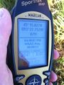
Meetup Coordinates
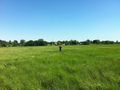
We have a Winner!
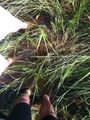
It got a little wet
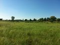
If you squint, you can see my car
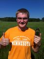
Thumbs Up


Achievements
ElectorCount and Mason earned the Land geohash achievement
|
ElectorCount earned the Drag-along achievement
|