Difference between revisions of "2012-05-04 38 -95"
imported>QuantumCop |
imported>Jiml m (Adjust result codes - sounds like you made it.) |
||
| Line 14: | Line 14: | ||
}} | }} | ||
| − | |||
__NOTOC__ | __NOTOC__ | ||
== Location == | == Location == | ||
| − | + | ||
In a large field of dirt near a baseball field, in Ottawa, KS | In a large field of dirt near a baseball field, in Ottawa, KS | ||
== Participants == | == Participants == | ||
| − | + | ||
| − | + | * [[User:QuantumCop|QuantumCop]] | |
| − | [[User:QuantumCop|QuantumCop]] | ||
<!-- | <!-- | ||
| Line 31: | Line 29: | ||
== Expedition == | == Expedition == | ||
| − | + | ||
As usual, I began heading south down Iowa St./US 59. Near the hashpoint, there was a park with a baseball field and some batting cages. I got out of my car and walked along a small maintenance road along a hill overlooking the baseball field. The hashpoint was in a field on the opposite side of the hill, so I headed down towards it. The whole field was made of soft soil, and it looked like there may have been plants growing there at one point. The point wasn't too far out into the field, so I walked a little ways out, following my GPS. I snapped a few pictures of the area along with my proof and a Stupid Grin, and then headed out. | As usual, I began heading south down Iowa St./US 59. Near the hashpoint, there was a park with a baseball field and some batting cages. I got out of my car and walked along a small maintenance road along a hill overlooking the baseball field. The hashpoint was in a field on the opposite side of the hill, so I headed down towards it. The whole field was made of soft soil, and it looked like there may have been plants growing there at one point. The point wasn't too far out into the field, so I walked a little ways out, following my GPS. I snapped a few pictures of the area along with my proof and a Stupid Grin, and then headed out. | ||
== Photos == | == Photos == | ||
| − | + | ||
| − | |||
| − | |||
<gallery perrow="5"> | <gallery perrow="5"> | ||
Image:2012-05-04_38_-95_point.jpg | The hashpoint is somewhere in the middle of this picture. | Image:2012-05-04_38_-95_point.jpg | The hashpoint is somewhere in the middle of this picture. | ||
| Line 45: | Line 41: | ||
</gallery> | </gallery> | ||
| − | + | ||
== Achievements == | == Achievements == | ||
{{#vardefine:ribbonwidth|800px}} | {{#vardefine:ribbonwidth|800px}} | ||
Add any achievement ribbons you earned below, or remove this section --> | Add any achievement ribbons you earned below, or remove this section --> | ||
| + | |||
| + | * Land Geohash (?) | ||
| Line 55: | Line 53: | ||
[[Category:New report]] | [[Category:New report]] | ||
| − | |||
| − | |||
| − | |||
| − | |||
| − | |||
[[Category:Expeditions]] | [[Category:Expeditions]] | ||
| − | + | ||
[[Category:Expeditions with photos]] | [[Category:Expeditions with photos]] | ||
| − | |||
| − | |||
| − | |||
| − | |||
| − | |||
[[Category:Coordinates reached]] | [[Category:Coordinates reached]] | ||
| − | |||
| − | |||
| − | |||
| − | |||
| − | |||
| − | |||
| − | |||
| − | |||
| − | |||
| − | |||
Revision as of 04:47, 13 June 2012
| Fri 4 May 2012 in 38,-95: 38.6134706, -95.2861907 geohashing.info google osm bing/os kml crox |
Location
In a large field of dirt near a baseball field, in Ottawa, KS
Participants
Expedition
As usual, I began heading south down Iowa St./US 59. Near the hashpoint, there was a park with a baseball field and some batting cages. I got out of my car and walked along a small maintenance road along a hill overlooking the baseball field. The hashpoint was in a field on the opposite side of the hill, so I headed down towards it. The whole field was made of soft soil, and it looked like there may have been plants growing there at one point. The point wasn't too far out into the field, so I walked a little ways out, following my GPS. I snapped a few pictures of the area along with my proof and a Stupid Grin, and then headed out.
Photos
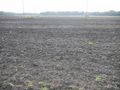
The hashpoint is somewhere in the middle of this picture.
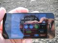
My proof of reaching the hashpoint.
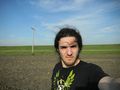
Stupid Grin
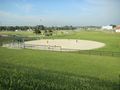
A baseball field near the hashpoint.


Achievements
Add any achievement ribbons you earned below, or remove this section -->
- Land Geohash (?)