Difference between revisions of "2012-06-17 32 -117"
imported>LucasBrown ([live picture] The hashpoint [http://www.openstreetmap.org/?lat=32.81773336&lon=-117.05835033&zoom=16&layers=B000FTF @32.8177,-117.0584]) |
imported>JesseW (add writeup of mine, add Lucas as a participant) |
||
| Line 17: | Line 17: | ||
<!-- who attended: If you link to your wiki user name in this section, your expedition will be picked up by the various statistics generated for geohashing. You may use three tildes ~ as a shortcut to automatically insert the user signature of the account you are editing with. | <!-- who attended: If you link to your wiki user name in this section, your expedition will be picked up by the various statistics generated for geohashing. You may use three tildes ~ as a shortcut to automatically insert the user signature of the account you are editing with. | ||
--> | --> | ||
| − | [[User:JesseW|JesseW]] | + | * [[User:JesseW|JesseW]] |
| + | * [[User:LucasBrown|LucasBrown]] | ||
== Plans == | == Plans == | ||
| Line 25: | Line 26: | ||
== Expedition == | == Expedition == | ||
<!-- how it all turned out. your narrative goes here. --> | <!-- how it all turned out. your narrative goes here. --> | ||
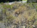
| + | It was very easy. Drove out to the Jackson Dr. intersection, parked in the overflow parking lot, walked a few minutes down the path, to the closest point (about 17 meters away, give or take 3 meters). Asked some fellow hikers to take a picture of me, and took pictures of my GPS. I didn't go off the path because it was fragile county (see sign pictured below). Then I walked around to the closest point on the road, which was also about the same distance away from the hash (on the other side), and snapped a few more shots. Pictures & tracklog to come. [[User:JesseW|JesseW]] 16:19, 17 June 2012 (EDT) | ||
== Tracklog == | == Tracklog == | ||
| Line 52: | Line 54: | ||
--> | --> | ||
| − | [[Category: | + | [[Category:Expeditions]] |
| + | [[Category:Expeditions with photos]] | ||
| + | [[Category:Coordinates reached]] | ||
<!-- An actual expedition: | <!-- An actual expedition: | ||
| − | |||
-- and one or more of -- | -- and one or more of -- | ||
| − | |||
[[Category:Expeditions with videos]] | [[Category:Expeditions with videos]] | ||
[[Category:Expedition without GPS]] | [[Category:Expedition without GPS]] | ||
| Line 63: | Line 65: | ||
<!-- if you reached your coords: | <!-- if you reached your coords: | ||
| − | |||
--> | --> | ||
Revision as of 20:19, 17 June 2012
| Sun 17 Jun 2012 in 32,-117: 32.8176662, -117.0583536 geohashing.info google osm bing/os kml crox |
Location
Just off of Mission Gorge Rd, near Jackson Dr.
Participants
Plans
Going to head out as soon as possible, probably getting there by 10:30 AM. JesseW 12:29, 17 June 2012 (EDT)
Expedition
It was very easy. Drove out to the Jackson Dr. intersection, parked in the overflow parking lot, walked a few minutes down the path, to the closest point (about 17 meters away, give or take 3 meters). Asked some fellow hikers to take a picture of me, and took pictures of my GPS. I didn't go off the path because it was fragile county (see sign pictured below). Then I walked around to the closest point on the road, which was also about the same distance away from the hash (on the other side), and snapped a few more shots. Pictures & tracklog to come. JesseW 16:19, 17 June 2012 (EDT)
Tracklog
Photos
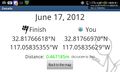
Less than a meter from the hashpoint @32.8177,-117.0583
The hashpoint @32.8177,-117.0584


Achievements