Difference between revisions of "2012-06-17 32 -117"
imported>JesseW (add writeup of mine, add Lucas as a participant) |
imported>LucasBrown |
||
| Line 1: | Line 1: | ||
| − | |||
| − | |||
| − | |||
{{meetup graticule | {{meetup graticule | ||
| lat=32 | | lat=32 | ||
| Line 8: | Line 5: | ||
}} | }} | ||
| − | |||
__NOTOC__ | __NOTOC__ | ||
== Location == | == Location == | ||
| − | |||
Just off of Mission Gorge Rd, near Jackson Dr. | Just off of Mission Gorge Rd, near Jackson Dr. | ||
== Participants == | == Participants == | ||
| − | |||
| − | |||
* [[User:JesseW|JesseW]] | * [[User:JesseW|JesseW]] | ||
| − | * [[User:LucasBrown|LucasBrown]] | + | * [[User:LucasBrown|LucasBrown]] -- reached the hashpoint at about 12:15. |
== Plans == | == Plans == | ||
| − | |||
Going to head out as soon as possible, probably getting there by 10:30 AM. [[User:JesseW|JesseW]] 12:29, 17 June 2012 (EDT) | Going to head out as soon as possible, probably getting there by 10:30 AM. [[User:JesseW|JesseW]] 12:29, 17 June 2012 (EDT) | ||
| + | |||
== Expedition == | == Expedition == | ||
<!-- how it all turned out. your narrative goes here. --> | <!-- how it all turned out. your narrative goes here. --> | ||
It was very easy. Drove out to the Jackson Dr. intersection, parked in the overflow parking lot, walked a few minutes down the path, to the closest point (about 17 meters away, give or take 3 meters). Asked some fellow hikers to take a picture of me, and took pictures of my GPS. I didn't go off the path because it was fragile county (see sign pictured below). Then I walked around to the closest point on the road, which was also about the same distance away from the hash (on the other side), and snapped a few more shots. Pictures & tracklog to come. [[User:JesseW|JesseW]] 16:19, 17 June 2012 (EDT) | It was very easy. Drove out to the Jackson Dr. intersection, parked in the overflow parking lot, walked a few minutes down the path, to the closest point (about 17 meters away, give or take 3 meters). Asked some fellow hikers to take a picture of me, and took pictures of my GPS. I didn't go off the path because it was fragile county (see sign pictured below). Then I walked around to the closest point on the road, which was also about the same distance away from the hash (on the other side), and snapped a few more shots. Pictures & tracklog to come. [[User:JesseW|JesseW]] 16:19, 17 June 2012 (EDT) | ||
| + | |||
| + | My expedition followed essentially the same route, but stepped carefully off the path to the hashpoint itself. Met a fellow hasher who was out on his first expedition. [[User:LucasBrown|LucasBrown]] | ||
== Tracklog == | == Tracklog == | ||
| Line 37: | Line 32: | ||
<gallery perrow="5"> | <gallery perrow="5"> | ||
| − | Image:2012-06-17_32_-117_12-12-18-792.jpg | Less than a meter from the hashpoint [http://www.openstreetmap.org/?lat=32.81772680&lon=-117.05834874&zoom=16&layers=B000FTF @32.8177,-117.0583] | + | Image:2012-06-17_32_-117_12-12-18-792.jpg | Less than a meter from the hashpoint ([[User:LucasBrown|LucasBrown]]) [http://www.openstreetmap.org/?lat=32.81772680&lon=-117.05834874&zoom=16&layers=B000FTF @32.8177,-117.0583] |
| − | Image:2012-06-17_32_-117_12-13-01-146.jpg | The hashpoint [http://www.openstreetmap.org/?lat=32.81773336&lon=-117.05835033&zoom=16&layers=B000FTF @32.8177,-117.0584] | + | Image:2012-06-17_32_-117_12-13-01-146.jpg | The hashpoint ([[User:LucasBrown|LucasBrown]]) [http://www.openstreetmap.org/?lat=32.81773336&lon=-117.05835033&zoom=16&layers=B000FTF @32.8177,-117.0584] |
</gallery> | </gallery> | ||
Revision as of 20:25, 17 June 2012
| Sun 17 Jun 2012 in 32,-117: 32.8176662, -117.0583536 geohashing.info google osm bing/os kml crox |
Location
Just off of Mission Gorge Rd, near Jackson Dr.
Participants
- JesseW
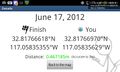
- LucasBrown -- reached the hashpoint at about 12:15.
Plans
Going to head out as soon as possible, probably getting there by 10:30 AM. JesseW 12:29, 17 June 2012 (EDT)
Expedition
It was very easy. Drove out to the Jackson Dr. intersection, parked in the overflow parking lot, walked a few minutes down the path, to the closest point (about 17 meters away, give or take 3 meters). Asked some fellow hikers to take a picture of me, and took pictures of my GPS. I didn't go off the path because it was fragile county (see sign pictured below). Then I walked around to the closest point on the road, which was also about the same distance away from the hash (on the other side), and snapped a few more shots. Pictures & tracklog to come. JesseW 16:19, 17 June 2012 (EDT)
My expedition followed essentially the same route, but stepped carefully off the path to the hashpoint itself. Met a fellow hasher who was out on his first expedition. LucasBrown
Tracklog
Photos
Less than a meter from the hashpoint (LucasBrown) @32.8177,-117.0583
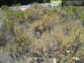
The hashpoint (LucasBrown) @32.8177,-117.0584


Achievements