Difference between revisions of "2012-06-24 51 12"
From Geohashing
imported>Bazaruto m (→Location) |
imported>FippeBot m (Location) |
||
| (4 intermediate revisions by one other user not shown) | |||
| Line 10: | Line 10: | ||
__NOTOC__ | __NOTOC__ | ||
== Location == | == Location == | ||
| − | The | + | The "Hölle" near Taucha. |
== Participants == | == Participants == | ||
[[User:Bazaruto|Bazaruto]] | [[User:Bazaruto|Bazaruto]] | ||
| − | |||
| − | |||
| − | |||
| − | |||
== Expedition == | == Expedition == | ||
| − | + | Mostly cycling alongside the river "Parthe", it was easy to get near the hash. But under the trees at the location my phone based gps was again a bit jumpy. By walking in circles I should have reached the hash anyway. And luckily there were no stinging nettles around. | |
| − | |||
| − | |||
| − | |||
== Photos == | == Photos == | ||
| Line 29: | Line 22: | ||
--> | --> | ||
<gallery perrow="5"> | <gallery perrow="5"> | ||
| + | Image:2012_06_24_51_12_pond.jpg | pond on my way | ||
| + | Image:2012_06_24_51_12_bike.jpg | my bike near the coordinates | ||
| + | Image:2012_06_24_51_12_coordinates.jpg | coordinates | ||
| + | Image:2012_06_24_51_12_grin.jpg | my grin | ||
</gallery> | </gallery> | ||
| − | |||
| − | |||
| − | |||
| − | |||
| − | |||
<!-- =============== USEFUL CATEGORIES FOLLOW ================ | <!-- =============== USEFUL CATEGORIES FOLLOW ================ | ||
| − | |||
| − | |||
<!-- Potential categories. Please include all the ones appropriate to your expedition --> | <!-- Potential categories. Please include all the ones appropriate to your expedition --> | ||
| − | |||
| − | |||
| − | |||
| − | |||
[[Category:Expeditions]] | [[Category:Expeditions]] | ||
| − | |||
[[Category:Expeditions with photos]] | [[Category:Expeditions with photos]] | ||
| − | |||
| − | |||
| − | |||
| − | |||
| − | |||
[[Category:Coordinates reached]] | [[Category:Coordinates reached]] | ||
| − | + | {{location|DE|SN|TDO}} | |
| − | |||
| − | |||
| − | |||
| − | |||
| − | |||
| − | |||
| − | |||
| − | |||
| − | |||
Latest revision as of 04:43, 13 August 2019
| Sun 24 Jun 2012 in 51,12: 51.3918425, 12.4812542 geohashing.info google osm bing/os kml crox |
Location
The "Hölle" near Taucha.
Participants
Expedition
Mostly cycling alongside the river "Parthe", it was easy to get near the hash. But under the trees at the location my phone based gps was again a bit jumpy. By walking in circles I should have reached the hash anyway. And luckily there were no stinging nettles around.
Photos
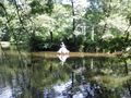
pond on my way
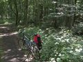
my bike near the coordinates
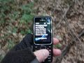
coordinates

my grin


