Difference between revisions of "2012-06-27 -32 115"
imported>Nick mz (Created page with "{{meetup graticule | lat=-32 | lon=115 | date=2012-06-27 }} == Location == Today's hash in the Freemantle graticule was just a few metres off the walkway in the Calista Oval P...") |
imported>Nick mz |
||
| Line 17: | Line 17: | ||
<gallery> | <gallery> | ||
Image:2012_06_27_-32_115_proof.jpg|The obligatory picture of my GPS device. | Image:2012_06_27_-32_115_proof.jpg|The obligatory picture of my GPS device. | ||
| − | Image:2012_06_27_- | + | Image:2012_06_27_-32_115_phone.png|Screenshot of Nicholas Killewald's app. The telephone disagreed with the Garmin device. |
| − | Image:2012_06_27_- | + | Image:2012_06_27_-32_115_hash.jpg|Grasstrees at the hash point. |
Image:2012_06_27_-32_115_lookingback.jpg|On my way back. View towards the hash. | Image:2012_06_27_-32_115_lookingback.jpg|On my way back. View towards the hash. | ||
</gallery> | </gallery> | ||
Revision as of 05:29, 27 June 2012
| Wed 27 Jun 2012 in -32,115: -32.2418112, 115.8117686 geohashing.info google osm bing/os kml crox |
Location
Today's hash in the Freemantle graticule was just a few metres off the walkway in the Calista Oval Park in Kwinana.
Expedition: nick_mz
Finally a hash that was easily accessible for those using public transport. In fact, it was one of the most conveniently reachable hashes I ever went to. Mandurah line to Kwinana, bus to the shopping centre, crossing the road and there I was. Planning the trip was facilitated by Nicholas Killewald's "Geohash Droid" app which made it easy to import the coordinates into Google Maps to use their superior public transport routing system. The Wiki does not list any previous activity in this graticule...
Gallery
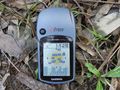
The obligatory picture of my GPS device.
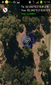
Screenshot of Nicholas Killewald's app. The telephone disagreed with the Garmin device.
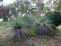
Grasstrees at the hash point.
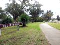
On my way back. View towards the hash.


