Difference between revisions of "2012-07-15 53 5"
imported>Shevek |
imported>Shevek |
||
| Line 1: | Line 1: | ||
| − | |||
| − | |||
| − | |||
| − | |||
| − | |||
| − | |||
| − | |||
| − | |||
| − | |||
| − | |||
{{meetup graticule | {{meetup graticule | ||
| lat=53 | | lat=53 | ||
| Line 15: | Line 5: | ||
}} | }} | ||
| − | |||
__NOTOC__ | __NOTOC__ | ||
== Location == | == Location == | ||
| − | + | In a grass triangle between two cycling roads in Burgum. | |
== Participants == | == Participants == | ||
| − | + | [[User:Shevek|Shevek]] | |
| − | |||
== Plans == | == Plans == | ||
| − | + | This hash, [[2012-07-15 52 4]] and [[2012-07-15 52 5]] were all positioned very nicely. I contemplated to do all, but decided not to. However, on IRC I heard that [[User:Eupeodes|Eupeodes]] was also going to Apeldoorn. Then I decided to do them all. First to Apeldoorn for the meetup, then to Breukelen and on the way back to Burgum. | |
== Expedition == | == Expedition == | ||
| − | + | But then I remembered that a friend of mine was going to pick up some stuff at my place. So I called him, that this would be a problem if I wouldn't be there. But he said he as about to leave to the Hague. So I changed the plan, to first go to Breukelen (so I could ride with him), then to Apeldoorn, and on the way back to Burgum. I cancelled the appointment in Apeldoorn, and waited for my friend. | |
| + | |||
| + | When I told him what I was going to do, he liked the idea. And he said he'd happily make a small detour to help me. So we drove over Burgum to Breukelen, both of which weren't exactly on his path. | ||
| + | |||
| + | Or was it, perhaps? We had to go through Zuidhorn, because he had to pick up stuff at another friend as well. Due to roads which were broken up, we were led a long way around the highway. I think it didn't go all the way to Burgum, but quite close nonetheless. | ||
| + | |||
| + | In Burgum, finding the place was easy. Getting my gps to work was not. So I walked all over the piece of grass which I remembered must have the hash on it, just to make sure I had been on it. However, looking it up now, I walked over the wrong piece of grass. But I was lucky: the hash was exactly on the grass which I crossed when walking from the bus stop (where we parked the car) to the wrong grass. So I have been there anyway. :-) | ||
| − | + | The story continues [[2012-07-15 52 4|here]] | |
| − | |||
== Photos == | == Photos == | ||
| Line 38: | Line 31: | ||
--> | --> | ||
<gallery perrow="5"> | <gallery perrow="5"> | ||
| + | Image:2012-07-15 53 5 grass1.jpg | Grass | ||
| + | Image:2012-07-15 53 5 grass2.jpg | More grass | ||
| + | Image:2012-07-15 53 5 grass3.jpg | Even more grass | ||
| + | Image:2012-07-15 53 5 grass4.jpg | Is that a boat? | ||
</gallery> | </gallery> | ||
== Achievements == | == Achievements == | ||
{{#vardefine:ribbonwidth|800px}} | {{#vardefine:ribbonwidth|800px}} | ||
| − | + | {{land geohash | |
| + | | latitude = 53 | ||
| + | | longitude = 5 | ||
| + | | date = 2012-07-15 | ||
| + | | name = [[User:Shevek|Shevek]] | ||
| + | | image = 2012-07-15 53 5 grass1.jpg | ||
| + | }} | ||
| + | {{Multihash2 | count = 3 | date = 2012-07-15 | name = [[User:Shevek|Shevek]] | image = 2012-07-15 53 5 grass4.jpg }} | ||
| − | |||
| − | |||
| − | |||
[[Category:New report]] | [[Category:New report]] | ||
| − | |||
| − | |||
| − | |||
| − | |||
| − | |||
| − | |||
[[Category:Expeditions]] | [[Category:Expeditions]] | ||
| − | |||
[[Category:Expeditions with photos]] | [[Category:Expeditions with photos]] | ||
| − | |||
| − | |||
| − | |||
| − | |||
| − | |||
[[Category:Coordinates reached]] | [[Category:Coordinates reached]] | ||
| − | |||
| − | |||
| − | |||
| − | |||
| − | |||
| − | |||
| − | |||
| − | |||
| − | |||
| − | |||
| − | |||
| − | |||
| − | |||
| − | |||
| − | |||
| − | |||
| − | |||
| − | |||
Revision as of 22:49, 15 July 2012
| Sun 15 Jul 2012 in 53,5: 53.1840800, 5.9890418 geohashing.info google osm bing/os kml crox |
Location
In a grass triangle between two cycling roads in Burgum.
Participants
Plans
This hash, 2012-07-15 52 4 and 2012-07-15 52 5 were all positioned very nicely. I contemplated to do all, but decided not to. However, on IRC I heard that Eupeodes was also going to Apeldoorn. Then I decided to do them all. First to Apeldoorn for the meetup, then to Breukelen and on the way back to Burgum.
Expedition
But then I remembered that a friend of mine was going to pick up some stuff at my place. So I called him, that this would be a problem if I wouldn't be there. But he said he as about to leave to the Hague. So I changed the plan, to first go to Breukelen (so I could ride with him), then to Apeldoorn, and on the way back to Burgum. I cancelled the appointment in Apeldoorn, and waited for my friend.
When I told him what I was going to do, he liked the idea. And he said he'd happily make a small detour to help me. So we drove over Burgum to Breukelen, both of which weren't exactly on his path.
Or was it, perhaps? We had to go through Zuidhorn, because he had to pick up stuff at another friend as well. Due to roads which were broken up, we were led a long way around the highway. I think it didn't go all the way to Burgum, but quite close nonetheless.
In Burgum, finding the place was easy. Getting my gps to work was not. So I walked all over the piece of grass which I remembered must have the hash on it, just to make sure I had been on it. However, looking it up now, I walked over the wrong piece of grass. But I was lucky: the hash was exactly on the grass which I crossed when walking from the bus stop (where we parked the car) to the wrong grass. So I have been there anyway. :-)
The story continues here
Photos
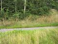
Grass
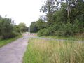
More grass
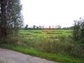
Even more grass
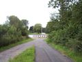
Is that a boat?


Achievements
Shevek earned the Land geohash achievement
|
Shevek earned the Multihash Achievement
|