Difference between revisions of "2012-07-27 62 6"
imported>Gefrierbrand (→Tracklog) |
imported>Gefrierbrand |
||
| Line 15: | Line 15: | ||
<!-- edit as necessary --> | <!-- edit as necessary --> | ||
| − | |||
== Location == | == Location == | ||
South-eastern of [[Ålesund,_Norway]], in the woods on a hillside somewhat near a few houses which might be called town or settlement, but don't even have a town sign, at least none I noticed. | South-eastern of [[Ålesund,_Norway]], in the woods on a hillside somewhat near a few houses which might be called town or settlement, but don't even have a town sign, at least none I noticed. | ||
| Line 27: | Line 26: | ||
== Plans == | == Plans == | ||
<!-- what were the original plans --> | <!-- what were the original plans --> | ||
| − | + | This summer holiday was all about traveling around in Scandinavia. A buddy from University and I decided to go up north to see Norway and Sweden, both astonishingly beautiful countries. Even in the planning stages of our trip (if they can be called that, because there really was almost no planning ahead) I thought about geohashing and how to reach the points. Due to the fact that I didn't want to pay for roaming, we only had Internet access at our stay in Ålesund. I noticed the points nearly ideal location as it did not fell in water or ontop of a mountain or some other unreachable place, of which there are quite a few in Norway. | |
== Expedition == | == Expedition == | ||
<!-- how it all turned out. your narrative goes here. --> | <!-- how it all turned out. your narrative goes here. --> | ||
| − | + | As I finished convincing T.W. to go on an even bigger adventure than the trip itself and had pointed out the possibility of achievements, the only thing left to do was entering the necessary data into [http://www.navit-project.org/ Navit] and head on. We went along a beautiful road which we had intended to use anyways and only took a small detour in favor of the hash. In really sunny and hot weather, we made the last few hundred meters on foot on a farm track before we had to go strait through the woods. I had left geohashdroid running on my phone since Ålesund and therefore even had a sky view for orientation, which did not help at all, as expected. We headed through boggy forest soil, over small and medium creeks, and stopped every five meters to take pictures of flowers, the surrounding mountains or some roaming cows. | |
| + | As always, the trees got bigger and denser which lead to decreasing GPS signal strength, but as the tracklog shows, I almost certainly passed through the point at some time. I even spent quite some time running around in circles while looking silly with my phone in front of me. | ||
| + | We then declared the point as reached on own authority, took the celebratory silly grin picture and headed back while taking even more pictures and continued our trip heading in the general direction of Trondheim, but that's a different story. | ||
== Tracklog == | == Tracklog == | ||
Revision as of 11:12, 3 August 2012
| Fri 27 Jul 2012 in 62,6: 62.2910436, 6.6299855 geohashing.info google osm bing/os kml crox |
Location
South-eastern of Ålesund,_Norway, in the woods on a hillside somewhat near a few houses which might be called town or settlement, but don't even have a town sign, at least none I noticed.
Participants
- Gefrierbrand
- T.W.
Plans
This summer holiday was all about traveling around in Scandinavia. A buddy from University and I decided to go up north to see Norway and Sweden, both astonishingly beautiful countries. Even in the planning stages of our trip (if they can be called that, because there really was almost no planning ahead) I thought about geohashing and how to reach the points. Due to the fact that I didn't want to pay for roaming, we only had Internet access at our stay in Ålesund. I noticed the points nearly ideal location as it did not fell in water or ontop of a mountain or some other unreachable place, of which there are quite a few in Norway.
Expedition
As I finished convincing T.W. to go on an even bigger adventure than the trip itself and had pointed out the possibility of achievements, the only thing left to do was entering the necessary data into Navit and head on. We went along a beautiful road which we had intended to use anyways and only took a small detour in favor of the hash. In really sunny and hot weather, we made the last few hundred meters on foot on a farm track before we had to go strait through the woods. I had left geohashdroid running on my phone since Ålesund and therefore even had a sky view for orientation, which did not help at all, as expected. We headed through boggy forest soil, over small and medium creeks, and stopped every five meters to take pictures of flowers, the surrounding mountains or some roaming cows. As always, the trees got bigger and denser which lead to decreasing GPS signal strength, but as the tracklog shows, I almost certainly passed through the point at some time. I even spent quite some time running around in circles while looking silly with my phone in front of me. We then declared the point as reached on own authority, took the celebratory silly grin picture and headed back while taking even more pictures and continued our trip heading in the general direction of Trondheim, but that's a different story.
Tracklog
Photos
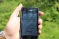
Taken somewhere near the hash as the GPS signal dropped down before I could take a picture with a closer value.
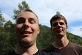
Stupid Grin including DragAlong T.W. (left)


Lots more will follow
Achievements
Gefrierbrand earned the Drag-along achievement
|
This might qualify for virgin graticule, but I'm not sure if anyone else has had a successful expedition here. If no one complaines I'm going to take it when I'm filling in the details here, which should be at the end of this weak.