Difference between revisions of "2012-07-27 62 6"
imported>Gefrierbrand (→Photos) |
imported>Eldin m (clean up template, check categories, and add achievement banners.) |
||
| Line 1: | Line 1: | ||
| − | |||
| − | |||
| − | |||
| − | |||
| − | |||
| − | |||
| − | |||
| − | |||
| − | |||
{{meetup graticule | {{meetup graticule | ||
| lat=62 | | lat=62 | ||
| Line 14: | Line 5: | ||
}} | }} | ||
| − | |||
== Location == | == Location == | ||
South-eastern of [[Ålesund,_Norway]], in the woods on a hillside somewhat near a few houses which might be called town or settlement, but don't even have a town sign, at least none I noticed. | South-eastern of [[Ålesund,_Norway]], in the woods on a hillside somewhat near a few houses which might be called town or settlement, but don't even have a town sign, at least none I noticed. | ||
== Participants == | == Participants == | ||
| − | + | * [[User:Gefrierbrand|Gefrierbrand]] | |
| − | + | * T.W. | |
| − | *[[User:Gefrierbrand|Gefrierbrand]] | ||
| − | *T.W. | ||
== Plans == | == Plans == | ||
| − | |||
This summer holiday was all about traveling around in Scandinavia. A buddy from University and I decided to go up north to see Norway and Sweden, both astonishingly beautiful countries. Even in the planning stages of our trip (if they can be called that, because there really was almost no planning ahead) I thought about geohashing and how to reach the points. Due to the fact that I didn't want to pay for roaming, we only had Internet access at our stay in Ålesund. I noticed the points nearly ideal location as it did not fell in water or ontop of a mountain or some other unreachable place, of which there are quite a few in Norway. | This summer holiday was all about traveling around in Scandinavia. A buddy from University and I decided to go up north to see Norway and Sweden, both astonishingly beautiful countries. Even in the planning stages of our trip (if they can be called that, because there really was almost no planning ahead) I thought about geohashing and how to reach the points. Due to the fact that I didn't want to pay for roaming, we only had Internet access at our stay in Ålesund. I noticed the points nearly ideal location as it did not fell in water or ontop of a mountain or some other unreachable place, of which there are quite a few in Norway. | ||
== Expedition == | == Expedition == | ||
| − | |||
As I finished convincing T.W. to go on an even bigger adventure than the trip itself and had pointed out the possibility of achievements, the only thing left to do was entering the necessary data into [http://www.navit-project.org/ Navit] and head on. We went along a beautiful road which we had intended to use anyways and only took a small detour in favor of the hash. In really sunny and hot weather, we made the last few hundred meters on foot on a farm track before we had to go strait through the woods. I had left geohashdroid running on my phone since Ålesund and therefore even had a sky view for orientation, which did not help at all, as expected. We headed through boggy forest soil, over small and medium creeks, and stopped every five meters to take pictures of flowers, the surrounding mountains or some roaming cows. | As I finished convincing T.W. to go on an even bigger adventure than the trip itself and had pointed out the possibility of achievements, the only thing left to do was entering the necessary data into [http://www.navit-project.org/ Navit] and head on. We went along a beautiful road which we had intended to use anyways and only took a small detour in favor of the hash. In really sunny and hot weather, we made the last few hundred meters on foot on a farm track before we had to go strait through the woods. I had left geohashdroid running on my phone since Ålesund and therefore even had a sky view for orientation, which did not help at all, as expected. We headed through boggy forest soil, over small and medium creeks, and stopped every five meters to take pictures of flowers, the surrounding mountains or some roaming cows. | ||
As always, the trees got bigger and denser which lead to decreasing GPS signal strength, but as the tracklog shows, I almost certainly passed through the point at some time. I even spent quite some time running around in circles while looking silly with my phone in front of me. | As always, the trees got bigger and denser which lead to decreasing GPS signal strength, but as the tracklog shows, I almost certainly passed through the point at some time. I even spent quite some time running around in circles while looking silly with my phone in front of me. | ||
| Line 35: | Line 21: | ||
== Tracklog == | == Tracklog == | ||
| − | |||
[https://www.dropbox.com/s/5e8rhsi3nfjavf8/27_07_2012%2012_20%20Hash%281%29.gpx Here you go] | [https://www.dropbox.com/s/5e8rhsi3nfjavf8/27_07_2012%2012_20%20Hash%281%29.gpx Here you go] | ||
== Photos == | == Photos == | ||
| − | |||
| − | |||
| − | |||
<gallery perrow="5"> | <gallery perrow="5"> | ||
File:2012-07-27 62 6 0.jpg | General area somewhat around the point. | File:2012-07-27 62 6 0.jpg | General area somewhat around the point. | ||
| Line 61: | Line 43: | ||
== Achievements == | == Achievements == | ||
{{#vardefine:ribbonwidth|800px}} | {{#vardefine:ribbonwidth|800px}} | ||
| − | + | {{drag-along | latitude = 62 | longitude = 6 | date = 2012-07-27 | partner = T.W. | name = [[User:Gefrierbrand|Gefrierbrand]]}} | |
| − | {{drag-along | + | {{Virgin graticule | latitude = 62 | longitude = 6 | date = 2012-07-27 | name = [[User:Gefrierbrand|Gefrierbrand]]}} |
| − | | latitude = 62 | + | {{land geohash | latitude = 62 | longitude = 6 | date = 2012-07-27 | name = [[User:Gefrierbrand|Gefrierbrand]]}} |
| − | | longitude = 6 | ||
| − | | date = 2012-07-27 | ||
| − | | partner = T.W. | ||
| − | | name = [[User:Gefrierbrand|Gefrierbrand]] | ||
| − | }} | ||
| − | {{Virgin graticule | ||
| − | |||
| − | |||
| − | |||
| − | |||
| − | |||
| − | |||
| − | |||
| − | |||
| − | |||
| − | |||
| − | |||
| − | |||
[[Category:Expeditions]] | [[Category:Expeditions]] | ||
| − | |||
| − | |||
| − | |||
[[Category:Expeditions with photos]] | [[Category:Expeditions with photos]] | ||
| − | + | [[Category:Coordinates reached]] | |
| − | |||
| − | |||
| − | [[Category:Coordinates reached]] | ||
| − | |||
| − | |||
| − | |||
| − | |||
| − | |||
| − | |||
| − | |||
| − | |||
| − | |||
| − | |||
| − | |||
| − | |||
| − | |||
| − | |||
| − | |||
| − | |||
| − | |||
| − | |||
| − | |||
| − | |||
Revision as of 21:10, 23 May 2013
| Fri 27 Jul 2012 in 62,6: 62.2910436, 6.6299855 geohashing.info google osm bing/os kml crox |
Location
South-eastern of Ålesund,_Norway, in the woods on a hillside somewhat near a few houses which might be called town or settlement, but don't even have a town sign, at least none I noticed.
Participants
- Gefrierbrand
- T.W.
Plans
This summer holiday was all about traveling around in Scandinavia. A buddy from University and I decided to go up north to see Norway and Sweden, both astonishingly beautiful countries. Even in the planning stages of our trip (if they can be called that, because there really was almost no planning ahead) I thought about geohashing and how to reach the points. Due to the fact that I didn't want to pay for roaming, we only had Internet access at our stay in Ålesund. I noticed the points nearly ideal location as it did not fell in water or ontop of a mountain or some other unreachable place, of which there are quite a few in Norway.
Expedition
As I finished convincing T.W. to go on an even bigger adventure than the trip itself and had pointed out the possibility of achievements, the only thing left to do was entering the necessary data into Navit and head on. We went along a beautiful road which we had intended to use anyways and only took a small detour in favor of the hash. In really sunny and hot weather, we made the last few hundred meters on foot on a farm track before we had to go strait through the woods. I had left geohashdroid running on my phone since Ålesund and therefore even had a sky view for orientation, which did not help at all, as expected. We headed through boggy forest soil, over small and medium creeks, and stopped every five meters to take pictures of flowers, the surrounding mountains or some roaming cows. As always, the trees got bigger and denser which lead to decreasing GPS signal strength, but as the tracklog shows, I almost certainly passed through the point at some time. I even spent quite some time running around in circles while looking silly with my phone in front of me. We then declared the point as reached on own authority, took the celebratory silly grin picture and headed back while taking even more pictures and continued our trip heading in the general direction of Trondheim, but that's a different story.
Tracklog
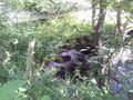
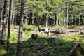
Photos
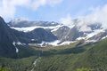
General area somewhat around the point.
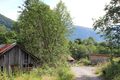
Beautiful old looking but still in use barn.
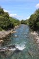
Nice stream we had to cross. Signs warned us about salmon parasites, but fishing was allowed nonetheless.
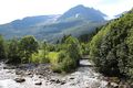
Did I mention how beautiful Norway is?
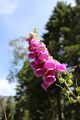
Probably an exemplar of Digitalis purpurea, which is highly poisonous.
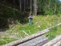
T.W. taking pictures of plants and landscape.
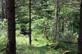
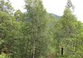
A small part of the forest we had to get through.
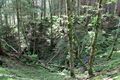
Even more forest including another creek.
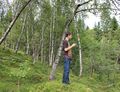
Me looking around for the best location...
... and hopelessly trying to get better reception.
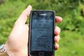
Taken somewhere near the hash as the GPS signal dropped down before I could take a picture with a closer value.
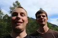
Stupid Grin including DragAlong T.W. (left)
An old and no longer in use concrete bridge where parts started to fall off already.
Freely roaming cows. Second cow not included in this picture


Achievements
Gefrierbrand earned the Drag-along achievement
|
Gefrierbrand earned the Land geohash achievement
|