Difference between revisions of "2012-07-30 52 4"
imported>Murfie (→Location) |
imported>FippeBot m (Location) |
||
| (5 intermediate revisions by one other user not shown) | |||
| Line 24: | Line 24: | ||
<!-- who attended: If you link to your wiki user name in this section, your expedition will be picked up by the various statistics generated for geohashing. You may use three tildes ~ as a shortcut to automatically insert the user signature of the account you are editing with. | <!-- who attended: If you link to your wiki user name in this section, your expedition will be picked up by the various statistics generated for geohashing. You may use three tildes ~ as a shortcut to automatically insert the user signature of the account you are editing with. | ||
--> | --> | ||
| + | [[User:Murfie|Murfie]] | ||
== Plans == | == Plans == | ||
<!-- what were the original plans --> | <!-- what were the original plans --> | ||
| + | |||
| + | The plan was to go there somewhere in the morning, because I happened | ||
| + | to go there nearby anyway. | ||
== Expedition == | == Expedition == | ||
<!-- how it all turned out. your narrative goes here. --> | <!-- how it all turned out. your narrative goes here. --> | ||
| + | |||
| + | I arrived late in the morning and parked my car at the CNB, | ||
| + | the 'De Coöperatieve Nederlandse Bloembollencentrale' (Lisse | ||
| + | is famous for their flower bulbs). | ||
| + | |||
| + | Then I crossed the road and a small wobbly bridge. There I saw | ||
| + | 2 fields. One with vegetation and one empty field, just earth. | ||
| + | |||
| + | There were some gardeners working in the field with the | ||
| + | vegetation and this turned out to be a research project for | ||
| + | wageningen University. | ||
| + | |||
| + | I walked to the empty field because the geohash was located | ||
| + | there. The gardeners just kept minding their own business, | ||
| + | I took a picture of myself at the geohash, and left. | ||
== Tracklog == | == Tracklog == | ||
| Line 39: | Line 58: | ||
--> | --> | ||
<gallery perrow="5"> | <gallery perrow="5"> | ||
| + | Image:2012-07-30_52_4_0551.jpg | Building on the other side of the road | ||
| + | Image:2012-07-30_52_4_0552.jpg | My feet at the geohash | ||
| + | Image:2012-07-30_52_4_0554.jpg | The geohash point is right there | ||
| + | Image:2012-07-30_52_4_0553.jpg | View from the geohash (gardeners) | ||
| + | Image:2012-07-30_52_4_0555.jpg | Sign explaining the purpose of the vegetation | ||
| + | Image:2012-07-30_52_4_0556.jpg | University of Wageningen is doing experiments here | ||
</gallery> | </gallery> | ||
== Achievements == | == Achievements == | ||
{{#vardefine:ribbonwidth|800px}} | {{#vardefine:ribbonwidth|800px}} | ||
| − | |||
| − | |||
| − | |||
| − | |||
| − | |||
| − | |||
| − | |||
| − | |||
| − | |||
| − | |||
| − | |||
| − | |||
[[Category:Expeditions]] | [[Category:Expeditions]] | ||
| − | |||
[[Category:Expeditions with photos]] | [[Category:Expeditions with photos]] | ||
| − | + | ||
| − | |||
| − | |||
| − | |||
| − | |||
[[Category:Coordinates reached]] | [[Category:Coordinates reached]] | ||
| − | + | {{location|NL|ZH}} | |
| − | |||
| − | |||
| − | |||
| − | |||
| − | |||
| − | |||
| − | |||
| − | |||
| − | |||
| − | |||
| − | |||
| − | |||
| − | |||
| − | |||
| − | |||
| − | |||
| − | |||
Latest revision as of 05:18, 13 August 2019
| Mon 30 Jul 2012 in 52,4: 52.2517686, 4.5457375 geohashing.info google osm bing/os kml crox |
Location
Lisse, The Netherlands
Participants
Plans
The plan was to go there somewhere in the morning, because I happened to go there nearby anyway.
Expedition
I arrived late in the morning and parked my car at the CNB, the 'De Coöperatieve Nederlandse Bloembollencentrale' (Lisse is famous for their flower bulbs).
Then I crossed the road and a small wobbly bridge. There I saw 2 fields. One with vegetation and one empty field, just earth.
There were some gardeners working in the field with the vegetation and this turned out to be a research project for wageningen University.
I walked to the empty field because the geohash was located there. The gardeners just kept minding their own business, I took a picture of myself at the geohash, and left.
Tracklog
Photos
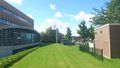
Building on the other side of the road
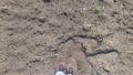
My feet at the geohash
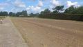
The geohash point is right there
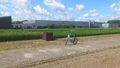
View from the geohash (gardeners)
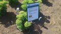
Sign explaining the purpose of the vegetation
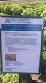
University of Wageningen is doing experiments here


