Difference between revisions of "2012-07-29 33 -84"
From Geohashing
imported>NWoodruff |
imported>FippeBot m (Location) |
||
| (One intermediate revision by one other user not shown) | |||
| Line 25: | Line 25: | ||
<gallery perrow="3"> | <gallery perrow="3"> | ||
Image:2012072933-84NW01.JPG | 14.5 feet to go. Close enough. | Image:2012072933-84NW01.JPG | 14.5 feet to go. Close enough. | ||
| − | Image: | + | Image:IMG 0328.JPG | Time of the meetup. |
Image:2012072933-84NW03.JPG | Date of the meetup. | Image:2012072933-84NW03.JPG | Date of the meetup. | ||
Image:2012072933-84NW04.JPG | Looking back towards the road. | Image:2012072933-84NW04.JPG | Looking back towards the road. | ||
| Line 38: | Line 38: | ||
[[Category:Expeditions with photos]] | [[Category:Expeditions with photos]] | ||
[[Category:Coordinates reached]] | [[Category:Coordinates reached]] | ||
| + | {{location|US|GA|FY}} | ||
Latest revision as of 05:16, 13 August 2019
| Sun 29 Jul 2012 in Atlanta: 33.5350379, -84.5237714 geohashing.info google osm bing/os kml crox |
Graticule
About
Down in a drainage ditch off to the side of a road in Union City.
Expedition
NWoodruff
Gallery
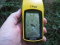
14.5 feet to go. Close enough.
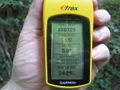
Time of the meetup.
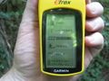
Date of the meetup.
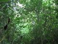
Looking back towards the road.

Me, standing on the Geohash spot with a Stupid Grin™
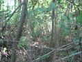
The path that I walked into the Geohash spot from.

Me with my older brother and his daughter.


