Difference between revisions of "2008-05-24 37 -121"
From Geohashing
imported>Ted m (added graticule name to meetup template) |
imported>Thomcat (Success/failure category added) |
||
| Line 53: | Line 53: | ||
Image:OverThere.jpg|Tapin's (daughter's) closest approach to the spot | Image:OverThere.jpg|Tapin's (daughter's) closest approach to the spot | ||
</gallery> | </gallery> | ||
| − | |||
[[Category:Expeditions]] | [[Category:Expeditions]] | ||
[[Category:Expeditions with photos]] | [[Category:Expeditions with photos]] | ||
| + | [[Category:Coordinates not reached]] | ||
| + | [[Category:Failed - Mother Nature]] | ||
| + | <!-- tough call, but based on captions, looks like the actual spot was not reached. Feel free to correct me! --> | ||
Revision as of 04:52, 5 August 2008
| Sat 24 May 2008 in San Jose, California: 37.1266480, -121.5475331 geohashing.info google osm bing/os kml crox |

Contents
About
These coordinates were located in the San Jose, California graticule on 2008-05-24, on the shore of Coyote Lake. This was the first Saturday meetup since the project went public.
37.126648°, -121.547534°
People
People who reached these coordinates:
- Joe (and his two kids)
- Dan
- Kate
- Jill
- Alex
- Albert
People who looked elsewhere:
- Ted LOL! I inadvertently went to Friday's (5/23)'s coordinates: 37.400246° -121.722772°. Turns out that location was behind private property, but I met some very nice ranchers :)
Events
After running into each other, we sat down and had a very nice picnic on the lake edge with beer, wine, cheese and other foodstuffs.
Pictures
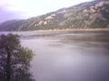
The lake near the spot
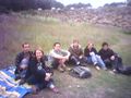
Random picnic
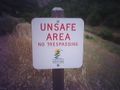
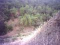
Sketchy terrain
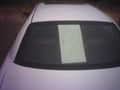
Back of a geohasher's car
Zigdon's closest approach to the spot
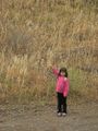
Tapin's (daughter's) closest approach to the spot


