Difference between revisions of "2012-08-10 47 -122"
From Geohashing
imported>Thomcat m (macro create) |
imported>FippeBot m (Location) |
||
| (5 intermediate revisions by one other user not shown) | |||
| Line 1: | Line 1: | ||
| − | |||
| − | |||
| − | |||
| − | |||
| − | |||
| − | |||
| − | |||
| − | |||
| − | |||
| − | |||
{{meetup graticule | {{meetup graticule | ||
| lat=47 | | lat=47 | ||
| Line 15: | Line 5: | ||
}} | }} | ||
| − | |||
__NOTOC__ | __NOTOC__ | ||
== Location == | == Location == | ||
| − | + | Just west of North Creek Park, a wetland with 3/4 mile of floating walkways. | |
== Participants == | == Participants == | ||
| − | + | [[User:Thomcat|Thomcat]] | |
| − | |||
== Plans == | == Plans == | ||
| − | + | Is there a path through the trees? | |
== Expedition == | == Expedition == | ||
| − | + | Drove in to North Creek park, then the next dead end street west of the park. The creek is about 15 feet across, depth unknown. It seems likely the hash itself is on dry ground. | |
| − | + | Going in from the park would mean crossing two or three creeks, not yet scouted. Going from the dead end would be shorter, but the geohasher would have to cross the confluence of all creeks, then hike through the woods (see picture). | |
| − | + | ||
| + | I'll probably scout the multi-creek approach after work (the geohash is 5km NW of here), but hold out little hope for achieving the hash point itself. | ||
== Photos == | == Photos == | ||
| − | |||
| − | |||
| − | |||
<gallery perrow="5"> | <gallery perrow="5"> | ||
| − | |||
| − | == | + | Image:2012-08-10_47_-122_16-10-41-915.jpg | [http://www.openstreetmap.org/?lat=47.83292555&lon=-122.22035892&zoom=16&layers=B000FTF @47.8329,-122.2204] |
| − | |||
| − | |||
| + | Image:2012-08-10_47_-122_16-18-03-803.jpg | 330 meters through wetlands [http://www.openstreetmap.org/?lat=47.83356299&lon=-122.21954410&zoom=16&layers=B000FTF @47.8336,-122.2195] | ||
| + | </gallery> | ||
| − | |||
| − | |||
| − | |||
| − | |||
| − | |||
| − | |||
| − | |||
| − | |||
| − | |||
| − | |||
[[Category:Expeditions]] | [[Category:Expeditions]] | ||
| − | |||
[[Category:Expeditions with photos]] | [[Category:Expeditions with photos]] | ||
| − | |||
| − | |||
| − | |||
| − | |||
| − | |||
| − | |||
| − | |||
| − | |||
| − | |||
[[Category:Coordinates not reached]] | [[Category:Coordinates not reached]] | ||
| − | |||
| − | |||
[[Category:Not reached - Mother Nature]] | [[Category:Not reached - Mother Nature]] | ||
| − | + | {{location|US|WA|SN}} | |
| − | |||
| − | |||
| − | |||
| − | |||
| − | |||
| − | |||
| − | |||
| − | |||
| − | |||
| − | |||
Latest revision as of 05:30, 13 August 2019
| Fri 10 Aug 2012 in 47,-122: 47.8347024, -122.2235842 geohashing.info google osm bing/os kml crox |
Location
Just west of North Creek Park, a wetland with 3/4 mile of floating walkways.
Participants
Plans
Is there a path through the trees?
Expedition
Drove in to North Creek park, then the next dead end street west of the park. The creek is about 15 feet across, depth unknown. It seems likely the hash itself is on dry ground.
Going in from the park would mean crossing two or three creeks, not yet scouted. Going from the dead end would be shorter, but the geohasher would have to cross the confluence of all creeks, then hike through the woods (see picture).
I'll probably scout the multi-creek approach after work (the geohash is 5km NW of here), but hold out little hope for achieving the hash point itself.
Photos
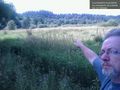
330 meters through wetlands @47.8336,-122.2195

