Difference between revisions of "2012-06-22 41 -89"
imported>RocketMac (Created page with "{{Subst:Expedition | lat = 41 | lon = -89 | date = 2012-06-22 }}") |
imported>FippeBot m (Location) |
||
| (10 intermediate revisions by 2 users not shown) | |||
| Line 1: | Line 1: | ||
| − | |||
| − | |||
| − | |||
| − | |||
| − | |||
| − | |||
| − | |||
| − | |||
| − | |||
| − | |||
{{meetup graticule | {{meetup graticule | ||
| lat=41 | | lat=41 | ||
| Line 15: | Line 5: | ||
}} | }} | ||
| − | |||
| − | |||
== Location == | == Location == | ||
| − | + | ||
| + | A cornfield in Toluca, Illinois. | ||
== Participants == | == Participants == | ||
| − | + | * [[User:RocketMac|RocketMac]] - On his way home from St. Louis, MO. | |
| − | |||
== Plans == | == Plans == | ||
| − | + | ||
| + | Every time I drive somewhere for work, I check the route for possible hashes along the way. Depending on timing, I could actually mark off the last two graticules for my [[Minesweeper_Geohash|Minesweeper]] award! | ||
| + | |||
| + | It'd been a long week of work and I wasn't getting on the road until after 5pm, so it was going to be pushing it. | ||
== Expedition == | == Expedition == | ||
| − | < | + | |
| + | I left St. Louis in the late afternoon and started homeward. My first stop was another crack at a Geocache called Night Signals. I <strike>wasted</strike> spent some time on that and then started my GPS tracklog heading for the hashpoint. | ||
| + | |||
| + | Other than being a bit out of my way, I made it with no problem and took some pictures. Added one more stop for my Minesweeper award and was on my way. | ||
== Tracklog == | == Tracklog == | ||
<!-- if your GPS device keeps a log, you may post a link here --> | <!-- if your GPS device keeps a log, you may post a link here --> | ||
| + | You can follow my tracklog in [http://coldshadow.com/geohashing/2012-06-22.gpx GPX] and [http://coldshadow.com/geohashing/2012-06-22.kmz KMZ] formats. | ||
== Photos == | == Photos == | ||
| − | |||
| − | |||
| − | |||
<gallery perrow="5"> | <gallery perrow="5"> | ||
| + | Image:RocketMac 2012-06-22 41 -89 01.jpg | Stupid Grin | ||
| + | Image:RocketMac 2012-06-22 41 -89 02.jpg | | ||
| + | Image:RocketMac 2012-06-22 41 -89 03.jpg | | ||
| + | Image:RocketMac 2012-06-22 41 -89 04.jpg | The geomobile | ||
| + | Image:RocketMac 2012-06-22 41 -89 05.jpg | | ||
| + | Image:RocketMac 2012-06-22 41 -89 06.jpg | GPS Reading | ||
</gallery> | </gallery> | ||
== Achievements == | == Achievements == | ||
{{#vardefine:ribbonwidth|800px}} | {{#vardefine:ribbonwidth|800px}} | ||
| − | + | {{land geohash | |
| − | + | | latitude = 41 | |
| + | | longitude = -89 | ||
| + | | date = 2012-06-22 | ||
| + | | name = RocketMac | ||
| + | | image = | ||
| + | }} | ||
| + | {{Minesweeper geohash | ||
| + | | graticule = Schaumburg, Illinois | ||
| + | | ranknumber = 7 | ||
| + | | n = true | ||
| + | | ne = true | ||
| + | | e = true | ||
| + | | se = true | ||
| + | | s = true | ||
| + | | sw = true | ||
| + | | w = | ||
| + | | nw = true | ||
| + | | name = RocketMac | ||
| + | }} | ||
| − | |||
| − | |||
| − | |||
| − | |||
| − | |||
| − | |||
| − | |||
| − | |||
[[Category:Expeditions]] | [[Category:Expeditions]] | ||
| − | |||
[[Category:Expeditions with photos]] | [[Category:Expeditions with photos]] | ||
| − | |||
| − | |||
| − | |||
| − | |||
| − | |||
[[Category:Coordinates reached]] | [[Category:Coordinates reached]] | ||
| − | + | {{location|US|IL|MH}} | |
| − | |||
| − | |||
| − | |||
| − | |||
| − | |||
| − | |||
| − | |||
| − | |||
| − | |||
| − | |||
| − | |||
| − | |||
| − | |||
| − | |||
| − | |||
| − | |||
| − | |||
Latest revision as of 04:57, 6 August 2019
| Fri 22 Jun 2012 in 41,-89: 41.0454491, -89.1228558 geohashing.info google osm bing/os kml crox |
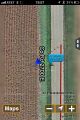
Location
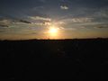
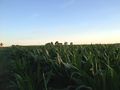
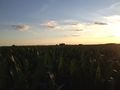
A cornfield in Toluca, Illinois.
Participants
- RocketMac - On his way home from St. Louis, MO.
Plans
Every time I drive somewhere for work, I check the route for possible hashes along the way. Depending on timing, I could actually mark off the last two graticules for my Minesweeper award!
It'd been a long week of work and I wasn't getting on the road until after 5pm, so it was going to be pushing it.
Expedition
I left St. Louis in the late afternoon and started homeward. My first stop was another crack at a Geocache called Night Signals. I wasted spent some time on that and then started my GPS tracklog heading for the hashpoint.
Other than being a bit out of my way, I made it with no problem and took some pictures. Added one more stop for my Minesweeper award and was on my way.
Tracklog
You can follow my tracklog in GPX and KMZ formats.
Photos

Stupid Grin
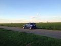
The geomobile
GPS Reading


Achievements
RocketMac earned the Land geohash achievement
|
RocketMac achieved level 7 of the Minesweeper Geohash achievement
|