Difference between revisions of "2012-08-15 50 2"
From Geohashing
imported>Zertrin m (Initialization) |
imported>Zertrin (Coordinates reached, graticule deflowered) |
||
| Line 1: | Line 1: | ||
| − | |||
<!-- If you did not specify these parameters in the template, please substitute appropriate values for IMAGE, LAT, LON, and DATE (YYYY-MM-DD format) | <!-- If you did not specify these parameters in the template, please substitute appropriate values for IMAGE, LAT, LON, and DATE (YYYY-MM-DD format) | ||
| Line 21: | Line 20: | ||
== Participants == | == Participants == | ||
| − | + | *[[User:Zertrin]] | |
| − | + | *His mother | |
== Plans == | == Plans == | ||
| Line 31: | Line 30: | ||
== Tracklog == | == Tracklog == | ||
| − | |||
== Photos == | == Photos == | ||
| − | |||
| − | |||
| − | |||
<gallery perrow="5"> | <gallery perrow="5"> | ||
| + | Image:2012-08-15_50_2_Zertrin_GPS.JPG | GPS Proof | ||
| + | Image:2012-08-15_50_2_Zertrin_Landscape.JPG | The landscape | ||
</gallery> | </gallery> | ||
| Line 43: | Line 40: | ||
{{#vardefine:ribbonwidth|800px}} | {{#vardefine:ribbonwidth|800px}} | ||
<!-- Add any achievement ribbons you earned below, or remove this section --> | <!-- Add any achievement ribbons you earned below, or remove this section --> | ||
| + | {{Virgin graticule | ||
| + | | latitude = 50 | ||
| + | | longitude = 2 | ||
| + | | date = 2012-08-15 | ||
| + | | name = [[User:Zertrin|Zertrin]] | ||
| + | | image = 2012-08-15_50_2_Zertrin_GPS.JPG | ||
| + | }} | ||
| + | {{drag-along | ||
| + | | latitude = 50 | ||
| + | | longitude = 2 | ||
| + | | date = 2012-08-15 | ||
| + | | partner = Zertrin's mother | ||
| + | | name = [[User:Zertrin|Zertrin]] | ||
| + | | image = | ||
| + | }} | ||
| − | |||
| − | |||
| − | |||
| − | |||
| − | |||
| − | |||
| − | |||
| − | |||
| − | |||
| − | |||
| − | |||
[[Category:Expeditions]] | [[Category:Expeditions]] | ||
| − | |||
[[Category:Expeditions with photos]] | [[Category:Expeditions with photos]] | ||
| − | |||
| − | |||
| − | |||
| − | |||
| − | |||
[[Category:Coordinates reached]] | [[Category:Coordinates reached]] | ||
| − | |||
| − | |||
| − | |||
| − | |||
| − | |||
| − | |||
| − | |||
| − | |||
| − | |||
| − | |||
| − | |||
| − | |||
| − | |||
| − | |||
| − | |||
| − | |||
| − | |||
| − | |||
Revision as of 19:30, 15 August 2012
| Wed 15 Aug 2012 in 50,2: 50.3082822, 2.4382585 geohashing.info google osm bing/os kml crox |
Location
Participants
- User:Zertrin
- His mother
Plans
Expedition
Tracklog
Photos
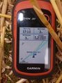
GPS Proof
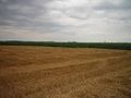
The landscape


Achievements
Zertrin earned the Drag-along achievement
|