Difference between revisions of "2012-08-19 48 -122"
imported>P4r4digm (An expedition message sent via Geohash Droid for Android.) |
imported>FippeBot m (Location) |
||
| (6 intermediate revisions by 2 users not shown) | |||
| Line 1: | Line 1: | ||
| − | |||
<!-- If you did not specify these parameters in the template, please substitute appropriate values for IMAGE, LAT, LON, and DATE (YYYY-MM-DD format) | <!-- If you did not specify these parameters in the template, please substitute appropriate values for IMAGE, LAT, LON, and DATE (YYYY-MM-DD format) | ||
| Line 13: | Line 12: | ||
| lon=-122 | | lon=-122 | ||
| date=2012-08-19 | | date=2012-08-19 | ||
| + | | graticule_name=Bellingham | ||
| + | | graticule_link=Bellingham, Washington | ||
}} | }} | ||
| − | + | ||
__NOTOC__ | __NOTOC__ | ||
== Location == | == Location == | ||
<!-- where you've surveyed the hash to be --> | <!-- where you've surveyed the hash to be --> | ||
| + | |||
| + | Farmer's land near Arlington | ||
== Participants == | == Participants == | ||
<!-- who attended: If you link to your wiki user name in this section, your expedition will be picked up by the various statistics generated for geohashing. You may use three tildes ~ as a shortcut to automatically insert the user signature of the account you are editing with. | <!-- who attended: If you link to your wiki user name in this section, your expedition will be picked up by the various statistics generated for geohashing. You may use three tildes ~ as a shortcut to automatically insert the user signature of the account you are editing with. | ||
--> | --> | ||
| + | :[[User:P4r4digm|P4r4digm]] | ||
== Plans == | == Plans == | ||
<!-- what were the original plans --> | <!-- what were the original plans --> | ||
| + | We knew we wanted to try and get to a hash leaving Ballard at 5. Opted for the one near Arlington because that's where Todd grew up. We were a little concerned about how close to someone's house the point was though. Especially on a Sunday evening. | ||
== Expedition == | == Expedition == | ||
<!-- how it all turned out. your narrative goes here. --> | <!-- how it all turned out. your narrative goes here. --> | ||
| + | *Geohash achieved! First non-seattle hash. Had to make like a tree when the farmer's dog started barking but totally made it :D -- [[User:P4r4digm|P4r4digm]] [http://www.openstreetmap.org/?lat=48.23497139&lon=-122.06715113&zoom=16&layers=B000FTF @48.2350,-122.0672] 19:14, 19 August 2012 (PDT) | ||
| + | |||
| + | Drove out to Arlington. I don't think I've ever been further north than Marysville in Washington. It was a fun and relaxing drive blasting punk gypsy rock. Arrived at the turnoff for the road leading to the point and saw a sign for fresh blueberries. A bit further down the road was a follow-up sign saying that the blueberry shop was closed. | ||
| − | + | We opted to park the car on the side of the entrance to the farm area (1500 feet from the mark) figuring that we may look less threatening if we were strolling along perhaps on a walk. The mark was in the trees a bit so we found a place where someone had clearly trampled a makeshift path through the brush. Ahead of us, in the field, was the mark. We made sure to sneak out and tag it but then a dog started barking so we retreated to the trees before snapping a proof picture. | |
| − | + | ||
| + | As we were leaving, a farmer left his house and started walking toward us. We continued our exit calmly but kept asking "is he still behind us? is he still behind us?" When we finally looked back he was closing the gate to his property and we breathed a sigh of relief. Not that farmers are scary but...farmers are scary! | ||
== Photos == | == Photos == | ||
| Line 38: | Line 47: | ||
--> | --> | ||
<gallery perrow="5"> | <gallery perrow="5"> | ||
| + | |||
| + | Image:2012-08-19_48_-122_18-58-39-414.jpg | Goofy grins abound. | ||
</gallery> | </gallery> | ||
| Line 47: | Line 58: | ||
<!-- =============== USEFUL CATEGORIES FOLLOW ================ | <!-- =============== USEFUL CATEGORIES FOLLOW ================ | ||
Delete the next line ONLY if you have chosen the appropriate categories below. If you are unsure, don't worry. People will read your report and help you with the classification. --> | Delete the next line ONLY if you have chosen the appropriate categories below. If you are unsure, don't worry. People will read your report and help you with the classification. --> | ||
| − | |||
<!-- Potential categories. Please include all the ones appropriate to your expedition --> | <!-- Potential categories. Please include all the ones appropriate to your expedition --> | ||
| Line 53: | Line 63: | ||
[[Category:Expedition planning]] | [[Category:Expedition planning]] | ||
--> | --> | ||
| + | |||
| + | |||
| + | [[Category:Expeditions]] | ||
| + | [[Category:Expeditions with photos]] | ||
| + | [[Category:Coordinates reached]] | ||
| + | |||
<!-- An actual expedition: | <!-- An actual expedition: | ||
| Line 82: | Line 98: | ||
(Don't forget to delete this final close comment marker) --> | (Don't forget to delete this final close comment marker) --> | ||
| + | {{location|US|WA|SN}} | ||
Latest revision as of 05:40, 13 August 2019
| Sun 19 Aug 2012 in Bellingham: 48.2624920, -122.0300963 geohashing.info google osm bing/os kml crox |
Location
Farmer's land near Arlington
Participants
Plans
We knew we wanted to try and get to a hash leaving Ballard at 5. Opted for the one near Arlington because that's where Todd grew up. We were a little concerned about how close to someone's house the point was though. Especially on a Sunday evening.
Expedition
- Geohash achieved! First non-seattle hash. Had to make like a tree when the farmer's dog started barking but totally made it :D -- P4r4digm @48.2350,-122.0672 19:14, 19 August 2012 (PDT)
Drove out to Arlington. I don't think I've ever been further north than Marysville in Washington. It was a fun and relaxing drive blasting punk gypsy rock. Arrived at the turnoff for the road leading to the point and saw a sign for fresh blueberries. A bit further down the road was a follow-up sign saying that the blueberry shop was closed.
We opted to park the car on the side of the entrance to the farm area (1500 feet from the mark) figuring that we may look less threatening if we were strolling along perhaps on a walk. The mark was in the trees a bit so we found a place where someone had clearly trampled a makeshift path through the brush. Ahead of us, in the field, was the mark. We made sure to sneak out and tag it but then a dog started barking so we retreated to the trees before snapping a proof picture.
As we were leaving, a farmer left his house and started walking toward us. We continued our exit calmly but kept asking "is he still behind us? is he still behind us?" When we finally looked back he was closing the gate to his property and we breathed a sigh of relief. Not that farmers are scary but...farmers are scary!
Photos
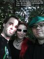
Goofy grins abound.
