Difference between revisions of "2012-08-26 50 8"
From Geohashing
imported>Mampfred m |
imported>FippeBot m (Location) |
||
| Line 59: | Line 59: | ||
[[Category:Expeditions with photos]] | [[Category:Expeditions with photos]] | ||
[[Category:Coordinates reached]] | [[Category:Coordinates reached]] | ||
| + | {{location|DE|HE|SWA}} | ||
Latest revision as of 05:49, 13 August 2019
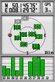
| Sun 26 Aug 2012 in 50,8: 50.1457475, 8.1297215 geohashing.info google osm bing/os kml crox |
Location
Right next to a street just out of Taunusstein.
Participants
Plans
It's sunday, the hash isn't far off and we all have spare time. Weather isn't brilliant but who cares about a little rain. The hash might be too easy so we might add a caching tour as well.
Expedition
We met up at 11:30 am and drove straight to the hash. This one really was too easy so we headed for the next geocache and ended up doing 14 in a row (plus one on the way back):
- GC39M7Q
- GC39M7R
- GC1HK2B
- GC39M7T
- GC39M7V
- GC39M7W
- GC1HJZT
- GC39M7X
- GC39M7Y
- GC1HK05
- GC39M7Z
- GC39M80
- GC1HK12
- GC39ART
- GC36RRQ
The one multi-cache that pretty much would have started where the hash was was in maintenance :(
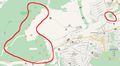
Fortunately the expected rain didn't show up (a couple drops here and there, nothing major) so we had a nice walk (7.2km in just under three hours).
Tracklog
See here.
Photos
Coordinates reached.

Stupid group-grin.
Geocaches


Achievements
- Land