Difference between revisions of "2012-08-26 49 8"
From Geohashing
imported>Palmpje m (Clean out the new report category) |
imported>FippeBot m (Location) |
||
| (3 intermediate revisions by 2 users not shown) | |||
| Line 1: | Line 1: | ||
| − | |||
| − | |||
| − | |||
| − | |||
| − | |||
| − | |||
| − | |||
| − | |||
| − | |||
{{meetup graticule | {{meetup graticule | ||
| lat=49 | | lat=49 | ||
| Line 45: | Line 36: | ||
{{#vardefine:ribbonwidth|800px}} | {{#vardefine:ribbonwidth|800px}} | ||
<!-- Add any achievement ribbons you earned below, or remove this section --> | <!-- Add any achievement ribbons you earned below, or remove this section --> | ||
| + | {{land geohash | ||
| + | | latitude = 49 | ||
| + | | longitude = 8 | ||
| + | | date = 2012-08-26 | ||
| + | | name = [[User:DLichti|DLichti]] | ||
| − | + | }} | |
| − | + | {{bicycle geohash | |
| + | | latitude = 49 | ||
| + | | longitude = 8 | ||
| + | | date = 2012-08-26 | ||
| + | | name = [[User:DLichti|DLichti]] | ||
| + | | distance = 8km | ||
| + | | bothways = true | ||
| + | | image = 2012-08-26_49_8_location.jpg | ||
| + | |||
| + | }} | ||
[[Category:Expeditions]] | [[Category:Expeditions]] | ||
| + | [[Category:Expeditions with photos]] | ||
[[Category:Coordinates reached]] | [[Category:Coordinates reached]] | ||
| − | + | {{location|DE|RP|SÜW}} | |
| − | |||
| − | |||
| − | |||
| − | |||
| − | |||
| − | |||
| − | |||
| − | |||
| − | |||
| − | |||
| − | |||
| − | |||
| − | |||
| − | |||
| − | |||
| − | |||
| − | |||
| − | |||
| − | |||
| − | |||
| − | |||
| − | |||
| − | |||
| − | |||
| − | |||
| − | |||
| − | |||
Latest revision as of 05:48, 13 August 2019
| Sun 26 Aug 2012 in 49,8: 49.1457475, 8.1297215 geohashing.info google osm bing/os kml crox |
Location
Between a corn field and a vineyard south of Landau in der Pfalz.
Participants
Expedition
As this hashpoint is quite close to where I live, I thought, this might be a good one to start with.
My dad and I used the occasion to jump on our bicycles and the wind was with us. We found the hashpoint in a typical south palatinate landscape at around 15:45.
We took some pictures and left the location. The weather didn't change and the wind was against us, but we finally made it back home.
Photos
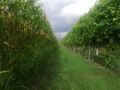
The hashpoint lies a few meters into the corn field to the left
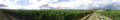
Beautiful southern palatinate landscape...

Achievements
DLichti earned the Land geohash achievement
|
DLichti earned the Bicycle geohash achievement
|