Difference between revisions of "2012-08-28 55 37"
From Geohashing
imported>Vb |
imported>FippeBot m (Location) |
||
| (7 intermediate revisions by 2 users not shown) | |||
| Line 18: | Line 18: | ||
== Location == | == Location == | ||
<!-- where you've surveyed the hash to be --> | <!-- where you've surveyed the hash to be --> | ||
| − | + | Kur'yanovo - a bit isolated residential area squeezed between [http://wikimapia.org/#lat=55.6615263&lon=37.7003149&z=15&l=1&m=b&show=/1700901/ru/%D0%9A%D1%83%D1%80%D1%8C%D1%8F%D0%BD%D0%BE%D0%B2%D1%81%D0%BA%D0%B8%D0%B5-%D0%BE%D1%87%D0%B8%D1%81%D1%82%D0%BD%D1%8B%D0%B5-%D1%81%D0%BE%D0%BE%D1%80%D1%83%D0%B6%D0%B5%D0%BD%D0%B8%D1%8F-%D0%9A%D0%9E%D0%A1-%D0%BF%D1%80%D0%BE%D0%B8%D0%B7%D0%B2%D0%BE%D0%B4%D1%81%D1%82%D0%B2%D0%B5%D0%BD%D0%BD%D0%BE%D0%B3%D0%BE-%D1%83%D0%BF%D1%80%D0%B0%D0%B2%D0%BB%D0%B5%D0%BD%D0%B8%D1%8F-%C2%AB%D0%9C%D0%BE%D1%81%D0%BE%D1%87%D0%B8%D1%81%D1%82%D0%B2%D0%BE%D0%B4%C2%BB waste water processing plant] and a railroad. About 30 minutes walk from nearest subway station. | |
== Participants == | == Participants == | ||
| Line 45: | Line 45: | ||
Image:2012-08-28_55_37_19-33-31-476.jpg | [http://www.openstreetmap.org/?lat=55.65918656&lon=37.70442781&zoom=16&layers=B000FTF @55.6592,37.7044] The spot. To GPS precision. | Image:2012-08-28_55_37_19-33-31-476.jpg | [http://www.openstreetmap.org/?lat=55.65918656&lon=37.70442781&zoom=16&layers=B000FTF @55.6592,37.7044] The spot. To GPS precision. | ||
| − | Image:2012-08-28_55_37_19-34-11-506.jpg | [http://www.openstreetmap.org/?lat=55.65916981&lon=37.70437440&zoom=16&layers=B000FTF @55.6592,37.7044] | + | Image:2012-08-28_55_37_19-34-11-506.jpg | [http://www.openstreetmap.org/?lat=55.65916981&lon=37.70437440&zoom=16&layers=B000FTF @55.6592,37.7044] GPS satellites. |
Image:2012-08-28_55_37_19-34-49-243.jpg | [http://www.openstreetmap.org/?lat=55.65913301&lon=37.70436783&zoom=16&layers=B000FTF @55.6591,37.7044] W | Image:2012-08-28_55_37_19-34-49-243.jpg | [http://www.openstreetmap.org/?lat=55.65913301&lon=37.70436783&zoom=16&layers=B000FTF @55.6591,37.7044] W | ||
| Line 51: | Line 51: | ||
Image:2012-08-28_55_37_19-35-23-537.jpg | [http://www.openstreetmap.org/?lat=55.65913629&lon=37.70438485&zoom=16&layers=B000FTF @55.6591,37.7044] S | Image:2012-08-28_55_37_19-35-23-537.jpg | [http://www.openstreetmap.org/?lat=55.65913629&lon=37.70438485&zoom=16&layers=B000FTF @55.6591,37.7044] S | ||
| − | Image:2012-08-28_55_37_19-35-55-259.jpg | [http://www.openstreetmap.org/?lat=55.65908762&lon=37.70437809&zoom=16&layers=B000FTF @55.6591,37.7044] A | + | Image:2012-08-28_55_37_19-35-55-259.jpg | [http://www.openstreetmap.org/?lat=55.65908762&lon=37.70437809&zoom=16&layers=B000FTF @55.6591,37.7044] D |
| + | |||
| + | Image:2012-08-28_19.31.39.jpg | [http://www.openstreetmap.org/?lat=55.65908762&lon=37.70437809&zoom=16&layers=B000FTF @55.6591,37.7044] A | ||
| + | |||
| + | Image:28082012567.jpg | ||
| + | |||
| + | Image:28082012571.jpg | ||
| + | |||
| + | Image:28082012572.jpg | ||
| + | |||
| + | Image:28082012573.jpg | ||
| + | |||
| + | Image:28082012574.jpg | ||
</gallery> | </gallery> | ||
| Line 61: | Line 73: | ||
<!-- =============== USEFUL CATEGORIES FOLLOW ================ | <!-- =============== USEFUL CATEGORIES FOLLOW ================ | ||
Delete the next line ONLY if you have chosen the appropriate categories below. If you are unsure, don't worry. People will read your report and help you with the classification. --> | Delete the next line ONLY if you have chosen the appropriate categories below. If you are unsure, don't worry. People will read your report and help you with the classification. --> | ||
| − | |||
<!-- Potential categories. Please include all the ones appropriate to your expedition --> | <!-- Potential categories. Please include all the ones appropriate to your expedition --> | ||
| Line 75: | Line 86: | ||
[[Category:Expedition without GPS]] | [[Category:Expedition without GPS]] | ||
--> | --> | ||
| − | + | [[Category:Expeditions]] | |
| − | + | [[Category:Expeditions with photos]] | |
[[Category:Coordinates reached]] | [[Category:Coordinates reached]] | ||
| + | [[Category:Public transport geohash achievement]] | ||
| − | + | <!-- or if you failed :( | |
| − | |||
[[Category:Coordinates not reached]] | [[Category:Coordinates not reached]] | ||
-- and a reason -- | -- and a reason -- | ||
| Line 96: | Line 107: | ||
(Don't forget to delete this final close comment marker) --> | (Don't forget to delete this final close comment marker) --> | ||
| + | {{location|RU|MOW}} | ||
Latest revision as of 05:51, 13 August 2019
| Tue 28 Aug 2012 in 55,37: 55.6591402, 37.7044357 geohashing.info google osm bing/os kml crox |
Location
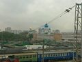
Kur'yanovo - a bit isolated residential area squeezed between waste water processing plant and a railroad. About 30 minutes walk from nearest subway station.
Participants
Plans
Just go there.
Expedition
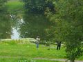
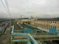
At the pond near the hash people were fishing. Which is a rare sight in Moscow nowadays. Adjacent railway station has some impressive old industrial buildings.
Tracklog
Photos
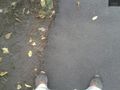
@55.6592,37.7044 The spot. To GPS precision.
@55.6592,37.7044 GPS satellites.