Difference between revisions of "2012-08-30 -35 149"
imported>1PE (→1PE) |
imported>1PE |
||
| Line 1: | Line 1: | ||
| − | + | [[Image:{{{image|2012-098-30 -35 149 picnic.JPG}}}|thumb|left]] | |
| − | |||
| − | [[Image:{{{image| | ||
| − | |||
| − | |||
| − | |||
| − | |||
| − | |||
| − | |||
{{meetup graticule | {{meetup graticule | ||
| lat=-35 | | lat=-35 | ||
| Line 49: | Line 41: | ||
===[[User:1PE|1PE]]=== | ===[[User:1PE|1PE]]=== | ||
<gallery perrow="5"> | <gallery perrow="5"> | ||
| − | + | File:2012-098-30 -35 149 AG.JPG|Beside the hash, and the dam. | |
| + | File:2012-08-30 -35 149 man.JPG|A man on the property, after all. | ||
| + | File:2012-098-30 -35 149 picnic.JPG|The picnic. | ||
| + | File:2012-098-30 -35 149 AG2.JPG|Dropping the AG flier. | ||
</gallery> | </gallery> | ||
| Line 61: | Line 56: | ||
| date = 2012-08-30 | | date = 2012-08-30 | ||
| name = 1PE | | name = 1PE | ||
| − | | image = | + | | image = 2012-098-30 -35 149 picnic.JPG |
| food = sandwiches and a drink | | food = sandwiches and a drink | ||
Revision as of 14:42, 30 August 2012

| Thu 30 Aug 2012 in -35,149: -35.4360332, 149.2057753 geohashing.info google osm bing/os kml crox |
Location
On a semi-rural property off the Old Cooma Road south of Queanbeyan, NSW.
Participants
Plans
1PE
Lunchtime; ~20km from work. This may be accessible from the adjacent side-road, but I may have to gaze at it and take a picture from a locked gate.
Expedition
1PE
This was out past two previous hashes: Karabar and the nearby hard-rock mine. I turned off the Old Cooma Road and went along the well-made rural road that services the small farms. I was able to recognise the two dams either side of the farm access road, and went in far enough to see that the house appeared locked up.
Back near the dam where the hash point is located, I got one picture. Then, I went out the farm gate to set up my picnic overlooking the farm dam with its ducks and the hash point just up-slope. While I was setting up, I saw a small truck going across the field just up-hill from the dam; a man got out and dealt with some equipment before going.
The picnic consisted of a tablecloth and checked towel, my lunch sandwiches on a china plate, and a drink from a china mug.
The ActiveGeohasher calling card went in the letterbox and I drove back to work.
Tracklog
Photos
1PE
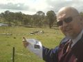
Beside the hash, and the dam.
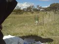
A man on the property, after all.
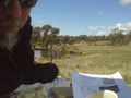
The picnic.
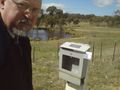
Dropping the AG flier.


Achievements
1PE
1PE earned the Picnic achievement
|