Difference between revisions of "2012-09-06 49 8"
From Geohashing
imported>DLichti m |
imported>Palmpje m (Cleaning out the New Report category) |
||
| Line 43: | Line 43: | ||
<!-- =============== USEFUL CATEGORIES FOLLOW ================ | <!-- =============== USEFUL CATEGORIES FOLLOW ================ | ||
| − | |||
| − | |||
| − | |||
<!-- Potential categories. Please include all the ones appropriate to your expedition --> | <!-- Potential categories. Please include all the ones appropriate to your expedition --> | ||
[[Category:Expeditions]] | [[Category:Expeditions]] | ||
Revision as of 15:54, 2 June 2013
| Thu 6 Sep 2012 in 49,8: 49.1720749, 8.3103159 geohashing.info google osm bing/os kml crox |
Location
A sown field near Rülzheim.
Participants
Expedition
What to say. A hashpoint about 18km from my place. We took out our bikes and went on. For the first part, I knew most tracks because we used to cycle there, but I didn't go there for about ten years now. The weather was good, we had little wind and so we reached the heashpoint at exactly 16:00. I tried to find the exact position on the field, but after running behind my smartphones' gps for several minutes, I thought, where ever the exact location was, I must have passed over it.
On the way back, we stopped by an austrich farm in Rülzheim.
Photos
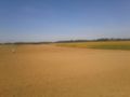
the hashpoint was located on that field.
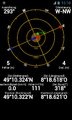
allmost there...
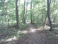
through the woods


