Difference between revisions of "2012-09-06 -35 149"
From Geohashing
imported>1PE m (Created page with "{{subst:Expedition |lat = =35 |lon = 149 |date = 2012-09-06}}") |
imported>1PE |
||
| Line 1: | Line 1: | ||
| + | [[Image:{{{image|2012-09-06 -35 149 site.JPG}}}|thumb|left]] | ||
| − | |||
| − | |||
| − | |||
| − | |||
| − | |||
| − | |||
| − | |||
| − | |||
| − | |||
{{meetup graticule | {{meetup graticule | ||
| − | | lat= | + | | lat= -35 |
| lon=149 | | lon=149 | ||
| date=2012-09-06 | | date=2012-09-06 | ||
| Line 18: | Line 10: | ||
__NOTOC__ | __NOTOC__ | ||
== Location == | == Location == | ||
| − | + | Just off a gravel road near the Federal Highway near Lake George. | |
== Participants == | == Participants == | ||
| − | + | [User:1PE|1PE]] | |
| − | |||
== Plans == | == Plans == | ||
| − | + | ===1PE=== | |
| + | Go on the way to a [[1957-09-06 -34 149|related hash]] near the southern edge of -34 149. | ||
== Expedition == | == Expedition == | ||
| − | + | ===1PE=== | |
| + | All good. Turned off the Federal Highway onto Donnely Road and followed it to the end on the dusty track, where the left turn was obvious. The hash was in scrubby field at the angle of the two tracks. I did not go into the houses at the twin gates, but a car drove past me as I was finishing the pictures. I dropped the ActiveGeohashing brochure into the appropriate letter box down the track. | ||
| − | == | + | == Photos == |
| − | |||
| − | |||
| − | |||
| − | |||
| − | |||
<gallery perrow="5"> | <gallery perrow="5"> | ||
| + | Image:2012-09-06 -35 149 site.JPG | Another one bites the dust. | ||
| + | Image:2012-09-06 -35 149 gates.JPG| Gates by the scrubby field; note the dusty road. | ||
</gallery> | </gallery> | ||
| Line 45: | Line 35: | ||
| − | + | ||
| − | |||
[[Category:New report]] | [[Category:New report]] | ||
| + | [[Category:Expeditions]] | ||
| − | |||
| − | |||
| − | |||
| − | |||
| − | |||
| − | |||
| − | |||
| − | |||
[[Category:Expeditions with photos]] | [[Category:Expeditions with photos]] | ||
| − | |||
[[Category:Expedition without GPS]] | [[Category:Expedition without GPS]] | ||
| − | + | ||
| − | |||
| − | |||
[[Category:Coordinates reached]] | [[Category:Coordinates reached]] | ||
| − | |||
| − | |||
| − | |||
| − | |||
| − | |||
| − | |||
| − | |||
| − | |||
| − | |||
| − | |||
| − | |||
| − | |||
| − | |||
| − | |||
| − | |||
| − | |||
| − | |||
| − | |||
Revision as of 07:47, 7 September 2012

| Thu 6 Sep 2012 in -35,149: -35.1720749, 149.3103159 geohashing.info google osm bing/os kml crox |
Location
Just off a gravel road near the Federal Highway near Lake George.
Participants
[User:1PE|1PE]]
Plans
1PE
Go on the way to a related hash near the southern edge of -34 149.
Expedition
1PE
All good. Turned off the Federal Highway onto Donnely Road and followed it to the end on the dusty track, where the left turn was obvious. The hash was in scrubby field at the angle of the two tracks. I did not go into the houses at the twin gates, but a car drove past me as I was finishing the pictures. I dropped the ActiveGeohashing brochure into the appropriate letter box down the track.
Photos
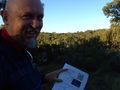
Another one bites the dust.
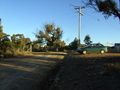
Gates by the scrubby field; note the dusty road.
