Difference between revisions of "2012-09-08 -37 144"
imported>Felix Dance m (Added stuff) |
imported>Felix Dance (Added text) |
||
| Line 13: | Line 13: | ||
==Expedition== | ==Expedition== | ||
=== [[User:Felix Dance|Felix Dance]] === | === [[User:Felix Dance|Felix Dance]] === | ||
| + | Well, now working in the mines in Central Australia, I get 6 days off every fortnight to muck around doing fun stuff I don't usually get a chance to do with only one day off a week. Sadly, I hadn't seen much in the way of good geohashes coming my way in the last couple of months. | ||
| + | |||
| + | However, on day three of a three-day solo cycle tour outside Melbourne's west, up to Mt Macedon to camp, then across to Ballarat and back in, I discovered a semi-achievable hash in a field. Since I'd spent the first two days wrecking my knees in battling against the headwind, this third day I decided to just let the wind decide where I'd be going. To this end I rocketed straight towards the hash south of Melton. | ||
| + | |||
| + | Within 10kms of the hash, I turned off a reasonably main highway onto a small sealed single-lane road. This then became a dirt track, then a pot-holed mud-fest, then a deep grassy strip between two-fields. The VicRoads Country Directory had lied to me - this was not a road. Still, with the awesome tail-wind behind me I was basically pushed through the muddy grasslands at a good speed, knowing that back-tracking would be impossible. I saw the highway veer off into the distance to my right. | ||
| + | |||
| + | After hurling my bike over a few locked gates I approached to within a couple of Ks. Here I discovered a newly built housing estate, still mostly unoccupied, which I used to travel the last section to the hash. Finally, a track I was riding on got to within 800m of the hash, so I ditched bike and legged it, took some photos of the desolate wasteland, and headed back to bike. | ||
| + | |||
| + | Riding out via the housing estate, I realised that this is possibly the most cul-de-sac-ed area I've ever seen. It took me about half an hour to get to the Melton train station, and another hour waiting and training home. A great geohashed end to a crazy cycle tour. | ||
[https://maps.google.com/maps?saddr=81+Capel+Street,+Melbourne,+Victoria,+Australia&daddr=-37.68356,144.95718+to:Craigieburn,+Victoria,+Australia+to:-37.5658332,144.908244+to:-37.5508184,144.8669444+to:-37.4390942,144.6064677+to:-37.4065051,144.6118756+to:Cameron+Drive%2FC328+to:Woodend,+Victoria,+Australia+to:-37.377519,144.538554+to:-37.390683,144.543715+to:-37.413153,144.472792+to:-37.3838735,144.4270979+to:Greendale+Trentham+Forest+Rd%2FC318+to:-37.4573253,144.211959+to:-37.4790922,144.1557481+to:-37.514741,144.075061+to:-37.526486,143.965057+to:Howitt+St%2FC287+to:Kendal+Ct+to:-37.596372,143.867487+to:-37.65927,143.91266+to:-37.707917,144.288616+to:-37.7951976,144.5457674+to:Melton,+Victoria,+Australia&hl=en&sll=-37.599,144.20105&sspn=0.466234,0.891953&geocode=FXIfv_0dd9WjCClDZ4y9Nl3WajGq0Sy3gBqvIA%3BFZj-wP0d_N6jCCkli_iSq1rWajGwtB7sdFYEEw%3BFRVLwv0d-KKjCCmDivMgMlLWajGgzowhdVYEBQ%3BFXfKwv0d1B-jCCmnbbcGtFPWajGweyvsdFYEEw%3BFR4Fw_0dgH6iCCk7FMlBclTWajExI1DsdFYEEw%3BFYq5xP0dA4WeCCkTsONM0uLWajHQDZ_Ip3kFEw%3BFdc4xf0dI5qeCCknC3UGrQLXajFgfG0OpHkFEw%3BFS6Nxf0daAyeCA%3BFWr6xf0drFOdCCm_yS-r_xzXajEg0qAwpHkFBQ%3BFRGqxf0dunudCCkhjMuL8R3XajEwBisOpHkFEw%3BFaV2xf0d44-dCCn_pT6v9R3XajFgdtgOpHkFEw%3BFd8exf0d2HqcCCnHXYlY5ODWajEQOXcOpHkFEw%3BFT-Rxf0dWcibCCkZTbMD09_WajGxGOgOpHkFEw%3BFXguxf0dmLGZCA%3BFVNyxP0d93-YCCl_syqU_s7WajEhtJkOpHkFEw%3BFUwdxP0dZKSXCCmTA_vB9cvWajERK6IOpHkFEw%3BFQuSw_0dNWmWCCkF8fm_TzXRajFxTjMOpHkFEw%3BFSpkw_0dgbuUCCkHfDCkBEnRajHgtpQOpHkFEw%3BFSgmw_0dQvWSCA%3BFfC9w_0d_2WSCA%3BFSxTwv0dXz6TCCntAdX41UTRajGgQwoOpHkFEw%3BFXpdwf0d1O6TCCmP9ooiglDRajGxmsEOpHkFEw%3BFXOfwP0daKuZCCmh70gyWbrWajEBRHAOpHkFEw%3BFYNKv_0d55edCCmDLDzPGJHWajGx-vrsdFYEEw%3BFd0Awf0dch-eCCl3YCzZkfHWajEg0IwhdVYEBQ&t=p&dirflg=b&mra=dme&mrsp=13&sz=11&via=1,3,4,5,6,9,10,11,12,14,15,16,17,20,21,22,23&lci=bike&z=10 Here] is the Google Maps route I took. | [https://maps.google.com/maps?saddr=81+Capel+Street,+Melbourne,+Victoria,+Australia&daddr=-37.68356,144.95718+to:Craigieburn,+Victoria,+Australia+to:-37.5658332,144.908244+to:-37.5508184,144.8669444+to:-37.4390942,144.6064677+to:-37.4065051,144.6118756+to:Cameron+Drive%2FC328+to:Woodend,+Victoria,+Australia+to:-37.377519,144.538554+to:-37.390683,144.543715+to:-37.413153,144.472792+to:-37.3838735,144.4270979+to:Greendale+Trentham+Forest+Rd%2FC318+to:-37.4573253,144.211959+to:-37.4790922,144.1557481+to:-37.514741,144.075061+to:-37.526486,143.965057+to:Howitt+St%2FC287+to:Kendal+Ct+to:-37.596372,143.867487+to:-37.65927,143.91266+to:-37.707917,144.288616+to:-37.7951976,144.5457674+to:Melton,+Victoria,+Australia&hl=en&sll=-37.599,144.20105&sspn=0.466234,0.891953&geocode=FXIfv_0dd9WjCClDZ4y9Nl3WajGq0Sy3gBqvIA%3BFZj-wP0d_N6jCCkli_iSq1rWajGwtB7sdFYEEw%3BFRVLwv0d-KKjCCmDivMgMlLWajGgzowhdVYEBQ%3BFXfKwv0d1B-jCCmnbbcGtFPWajGweyvsdFYEEw%3BFR4Fw_0dgH6iCCk7FMlBclTWajExI1DsdFYEEw%3BFYq5xP0dA4WeCCkTsONM0uLWajHQDZ_Ip3kFEw%3BFdc4xf0dI5qeCCknC3UGrQLXajFgfG0OpHkFEw%3BFS6Nxf0daAyeCA%3BFWr6xf0drFOdCCm_yS-r_xzXajEg0qAwpHkFBQ%3BFRGqxf0dunudCCkhjMuL8R3XajEwBisOpHkFEw%3BFaV2xf0d44-dCCn_pT6v9R3XajFgdtgOpHkFEw%3BFd8exf0d2HqcCCnHXYlY5ODWajEQOXcOpHkFEw%3BFT-Rxf0dWcibCCkZTbMD09_WajGxGOgOpHkFEw%3BFXguxf0dmLGZCA%3BFVNyxP0d93-YCCl_syqU_s7WajEhtJkOpHkFEw%3BFUwdxP0dZKSXCCmTA_vB9cvWajERK6IOpHkFEw%3BFQuSw_0dNWmWCCkF8fm_TzXRajFxTjMOpHkFEw%3BFSpkw_0dgbuUCCkHfDCkBEnRajHgtpQOpHkFEw%3BFSgmw_0dQvWSCA%3BFfC9w_0d_2WSCA%3BFSxTwv0dXz6TCCntAdX41UTRajGgQwoOpHkFEw%3BFXpdwf0d1O6TCCmP9ooiglDRajGxmsEOpHkFEw%3BFXOfwP0daKuZCCmh70gyWbrWajEBRHAOpHkFEw%3BFYNKv_0d55edCCmDLDzPGJHWajGx-vrsdFYEEw%3BFd0Awf0dch-eCCl3YCzZkfHWajEg0IwhdVYEBQ&t=p&dirflg=b&mra=dme&mrsp=13&sz=11&via=1,3,4,5,6,9,10,11,12,14,15,16,17,20,21,22,23&lci=bike&z=10 Here] is the Google Maps route I took. | ||
Revision as of 02:44, 10 September 2012
| Sat 8 Sep 2012 in -37,144: -37.8080342, 144.5599756 geohashing.info google osm bing/os kml crox |
Location
In a field south of Melton in Melbourne's West.
Who went
Expedition
Felix Dance
Well, now working in the mines in Central Australia, I get 6 days off every fortnight to muck around doing fun stuff I don't usually get a chance to do with only one day off a week. Sadly, I hadn't seen much in the way of good geohashes coming my way in the last couple of months.
However, on day three of a three-day solo cycle tour outside Melbourne's west, up to Mt Macedon to camp, then across to Ballarat and back in, I discovered a semi-achievable hash in a field. Since I'd spent the first two days wrecking my knees in battling against the headwind, this third day I decided to just let the wind decide where I'd be going. To this end I rocketed straight towards the hash south of Melton.
Within 10kms of the hash, I turned off a reasonably main highway onto a small sealed single-lane road. This then became a dirt track, then a pot-holed mud-fest, then a deep grassy strip between two-fields. The VicRoads Country Directory had lied to me - this was not a road. Still, with the awesome tail-wind behind me I was basically pushed through the muddy grasslands at a good speed, knowing that back-tracking would be impossible. I saw the highway veer off into the distance to my right.
After hurling my bike over a few locked gates I approached to within a couple of Ks. Here I discovered a newly built housing estate, still mostly unoccupied, which I used to travel the last section to the hash. Finally, a track I was riding on got to within 800m of the hash, so I ditched bike and legged it, took some photos of the desolate wasteland, and headed back to bike.
Riding out via the housing estate, I realised that this is possibly the most cul-de-sac-ed area I've ever seen. It took me about half an hour to get to the Melton train station, and another hour waiting and training home. A great geohashed end to a crazy cycle tour.
Here is the Google Maps route I took.
Hash reached: 6:10pm
Photos
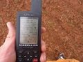
GPS Proof
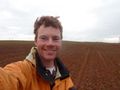
Felix at the hash
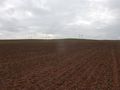
West view
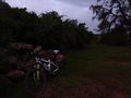
Hashbike


