Difference between revisions of "2012-09-08 -37 144"
imported>Felix Dance (Added text) |
imported>Felix Dance m |
||
| Line 34: | Line 34: | ||
Image:Geohash 2012-09-08 -37 144 Bike.JPG|Hashbike | Image:Geohash 2012-09-08 -37 144 Bike.JPG|Hashbike | ||
</gallery> | </gallery> | ||
| + | |||
| + | == Achievement == | ||
| + | {{Bicycle geohash | ||
| + | |||
| + | | latitude = -37 | ||
| + | | longitude = 144 | ||
| + | | date = 2012-09-08 | ||
| + | | name = [[User:Felix Dance|Felix Dance]] | ||
| + | | distance = 113kms | ||
| + | | image = Geohash 2012-09-08 -37 144 Bike.JPG.JPG | ||
| + | |||
| + | }} | ||
[[Category:Expeditions]] | [[Category:Expeditions]] | ||
[[Category:Coordinates reached]] | [[Category:Coordinates reached]] | ||
[[Category:Expeditions with photos]] | [[Category:Expeditions with photos]] | ||
Revision as of 04:01, 10 September 2012
| Sat 8 Sep 2012 in -37,144: -37.8080342, 144.5599756 geohashing.info google osm bing/os kml crox |
Location
In a field south of Melton in Melbourne's West.
Who went
Expedition
Felix Dance
Well, now working in the mines in Central Australia, I get 6 days off every fortnight to muck around doing fun stuff I don't usually get a chance to do with only one day off a week. Sadly, I hadn't seen much in the way of good geohashes coming my way in the last couple of months.
However, on day three of a three-day solo cycle tour outside Melbourne's west, up to Mt Macedon to camp, then across to Ballarat and back in, I discovered a semi-achievable hash in a field. Since I'd spent the first two days wrecking my knees in battling against the headwind, this third day I decided to just let the wind decide where I'd be going. To this end I rocketed straight towards the hash south of Melton.
Within 10kms of the hash, I turned off a reasonably main highway onto a small sealed single-lane road. This then became a dirt track, then a pot-holed mud-fest, then a deep grassy strip between two-fields. The VicRoads Country Directory had lied to me - this was not a road. Still, with the awesome tail-wind behind me I was basically pushed through the muddy grasslands at a good speed, knowing that back-tracking would be impossible. I saw the highway veer off into the distance to my right.
After hurling my bike over a few locked gates I approached to within a couple of Ks. Here I discovered a newly built housing estate, still mostly unoccupied, which I used to travel the last section to the hash. Finally, a track I was riding on got to within 800m of the hash, so I ditched bike and legged it, took some photos of the desolate wasteland, and headed back to bike.
Riding out via the housing estate, I realised that this is possibly the most cul-de-sac-ed area I've ever seen. It took me about half an hour to get to the Melton train station, and another hour waiting and training home. A great geohashed end to a crazy cycle tour.
Here is the Google Maps route I took.
Hash reached: 6:10pm
Photos
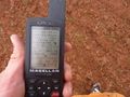
GPS Proof
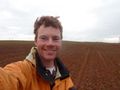
Felix at the hash
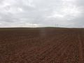
West view
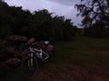
Hashbike


Achievement
Felix Dance earned the Bicycle geohash achievement
|