Difference between revisions of "2012-09-17 47 -122"
imported>Thomcat ([live picture] Marked the pavement [http://www.openstreetmap.org/?lat=47.87240667&lon=-122.22184802&zoom=16&layers=B000FTF @47.8724,-122.2218]) |
imported>Thomcat (Pictures and report) |
||
| Line 1: | Line 1: | ||
| − | |||
| − | |||
| − | |||
| − | |||
| − | |||
| − | |||
| − | |||
| − | |||
| − | |||
| − | |||
{{meetup graticule | {{meetup graticule | ||
| lat=47 | | lat=47 | ||
| lon=-122 | | lon=-122 | ||
| date=2012-09-17 | | date=2012-09-17 | ||
| + | | | ||
| + | | | ||
}} | }} | ||
| − | |||
__NOTOC__ | __NOTOC__ | ||
== Location == | == Location == | ||
| − | + | On a jogging/dog path in Mill Creek | |
== Participants == | == Participants == | ||
| − | + | *[[User:Thomcat|Thomcat]] | |
| − | |||
== Plans == | == Plans == | ||
| − | + | I stopped on my way to work; can stop again on my way home to meet with [[User:Boomzilla|Boomzilla]] --[[User:Thomcat|Thomcat]] 12:32, 17 September 2012 (EDT) | |
| − | == Expedition == | + | == Expedition #1 == |
| − | |||
| + | As usual, I checked the eleven geohash sites just before heading out the door. Hello, this one isn't too far off my route - and I have to stop at Costco anyhow! | ||
*The geohash is not far off my path to work today. -- [[User:Thomcat|Thomcat]] [http://www.openstreetmap.org/?lat=47.82515529&lon=-122.31112084&zoom=16&layers=B000FTF @47.8252,-122.3111] 07:33, 17 September 2012 (PDT) | *The geohash is not far off my path to work today. -- [[User:Thomcat|Thomcat]] [http://www.openstreetmap.org/?lat=47.82515529&lon=-122.31112084&zoom=16&layers=B000FTF @47.8252,-122.3111] 07:33, 17 September 2012 (PDT) | ||
| Line 35: | Line 25: | ||
*Less than 3 kilometers from my place. I'll try to visit. [[User:Boomzilla|Boomzilla]] 10:38, 17 September 2012 (EDT) | *Less than 3 kilometers from my place. I'll try to visit. [[User:Boomzilla|Boomzilla]] 10:38, 17 September 2012 (EDT) | ||
| − | + | The closest approach was from a residential complex with a thing for security apparently. I parked in a visitor spot and read a sign indicating that I needed a guest pass - where am I supposed to get that?!? No matter, I can always plead I was looking for the office... down this convenient dog path. Unfortunately, the path led to a gate to the path proper - locked of course. Sheesh! | |
| − | + | ||
| + | Leaving the complex, I drove up the road to some alternate parking. (to be continued) | ||
== Photos == | == Photos == | ||
| − | |||
| − | |||
| − | |||
<gallery perrow="5"> | <gallery perrow="5"> | ||
Image:2012-09-17_47_-122_07-55-07-173.jpg | No access this way... [http://www.openstreetmap.org/?lat=47.87200358&lon=-122.22136602&zoom=16&layers=B000FTF @47.8720,-122.2214] | Image:2012-09-17_47_-122_07-55-07-173.jpg | No access this way... [http://www.openstreetmap.org/?lat=47.87200358&lon=-122.22136602&zoom=16&layers=B000FTF @47.8720,-122.2214] | ||
| + | |||
| + | Image:2012-09-17 47 -122 HashParking.jpg | Overflow Geohash Parking | ||
| + | Image:2012-09-17 47 -122 Approach.jpg | Alternate approach, not hampered by locked gate | ||
| + | Image:2012-09-17 47 -122 LookingAway.jpg | Other end of the approach path | ||
| + | Image:2012-09-17 47 -122 LookingTowards.jpg | Geohash is just around the bend | ||
| + | Image:2012-09-17 47 -122 Dogs.jpg | Popular area for dog walking | ||
Image:2012-09-17_47_-122_08-02-42-901.jpg | At the spot [http://www.openstreetmap.org/?lat=47.87240720&lon=-122.22184626&zoom=16&layers=B000FTF @47.8724,-122.2218] | Image:2012-09-17_47_-122_08-02-42-901.jpg | At the spot [http://www.openstreetmap.org/?lat=47.87240720&lon=-122.22184626&zoom=16&layers=B000FTF @47.8724,-122.2218] | ||
| + | |||
| + | Image:2012-09-17 47 -122 Chalked.jpg | The XKCD marks | ||
Image:2012-09-17_47_-122_08-07-55-287.jpg | Marked the pavement [http://www.openstreetmap.org/?lat=47.87240667&lon=-122.22184802&zoom=16&layers=B000FTF @47.8724,-122.2218] | Image:2012-09-17_47_-122_08-07-55-287.jpg | Marked the pavement [http://www.openstreetmap.org/?lat=47.87240667&lon=-122.22184802&zoom=16&layers=B000FTF @47.8724,-122.2218] | ||
| + | |||
| + | Image:2012-09-17 47 -122 Uploading.jpg | Timed photo - Thomcat uploading on geohashdroid | ||
| + | |||
</gallery> | </gallery> | ||
| Line 55: | Line 54: | ||
<!-- Add any achievement ribbons you earned below, or remove this section --> | <!-- Add any achievement ribbons you earned below, or remove this section --> | ||
| − | |||
| − | |||
| − | |||
| − | |||
| − | |||
| − | |||
| − | |||
| − | |||
| − | |||
| − | |||
| − | |||
[[Category:Expeditions]] | [[Category:Expeditions]] | ||
| − | |||
[[Category:Expeditions with photos]] | [[Category:Expeditions with photos]] | ||
| − | |||
| − | |||
| − | |||
| − | |||
| − | |||
[[Category:Coordinates reached]] | [[Category:Coordinates reached]] | ||
| − | |||
| − | |||
| − | |||
| − | |||
| − | |||
| − | |||
| − | |||
| − | |||
| − | |||
| − | |||
| − | |||
| − | |||
| − | |||
| − | |||
| − | |||
| − | |||
| − | |||
| − | |||
Revision as of 16:32, 17 September 2012
| Mon 17 Sep 2012 in 47,-122: 47.8723680, -122.2218072 geohashing.info google osm bing/os kml crox |
Location
On a jogging/dog path in Mill Creek
Participants
Plans
I stopped on my way to work; can stop again on my way home to meet with Boomzilla --Thomcat 12:32, 17 September 2012 (EDT)
Expedition #1
As usual, I checked the eleven geohash sites just before heading out the door. Hello, this one isn't too far off my route - and I have to stop at Costco anyhow!
- The geohash is not far off my path to work today. -- Thomcat @47.8252,-122.3111 07:33, 17 September 2012 (PDT)
- Less than 3 kilometers from my place. I'll try to visit. Boomzilla 10:38, 17 September 2012 (EDT)
The closest approach was from a residential complex with a thing for security apparently. I parked in a visitor spot and read a sign indicating that I needed a guest pass - where am I supposed to get that?!? No matter, I can always plead I was looking for the office... down this convenient dog path. Unfortunately, the path led to a gate to the path proper - locked of course. Sheesh!
Leaving the complex, I drove up the road to some alternate parking. (to be continued)
Photos

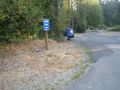
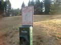
No access this way... @47.8720,-122.2214
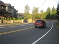
Overflow Geohash Parking
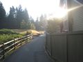
Alternate approach, not hampered by locked gate
Other end of the approach path
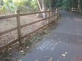
Geohash is just around the bend
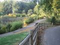
Popular area for dog walking

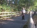
At the spot @47.8724,-122.2218
The XKCD marks
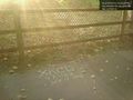
Marked the pavement @47.8724,-122.2218
Timed photo - Thomcat uploading on geohashdroid


