Difference between revisions of "2012-10-30 -35 149"
From Geohashing
imported>1PE |
imported>1PE m |
||
| Line 27: | Line 27: | ||
--> | --> | ||
<gallery perrow="5"> | <gallery perrow="5"> | ||
| − | Image: | + | Image:2012-10-30 -35 149 1PE.JPG|Me in the blackberry patch. |
Image:2o12-10-30 -35 149 proof.JPG|Inside the GPS's error pool. | Image:2o12-10-30 -35 149 proof.JPG|Inside the GPS's error pool. | ||
Image:2o12-10-30 -35 149 view.JPG|The area, including the 'forest' road used for car rallying. | Image:2o12-10-30 -35 149 view.JPG|The area, including the 'forest' road used for car rallying. | ||
Revision as of 12:33, 30 October 2012

| Tue 30 Oct 2012 in -35,149: -35.2965765, 149.0338569 geohashing.info google osm bing/os kml crox |
Location
On the margin of a former/current commercial pine plantation, about 10m to western the side of Coppins Crossing Road, south of Belconnen, Australian Capital Territory. A farmhouse is opposite, to the south-east.
Participants
Plans
1PE
On the way home from work, aiming for 5.30pm.
Expedition
1PE
Where expected, except that it was in a blackberry patch, so I had to tread carefully!
Photos

Me in the blackberry patch.
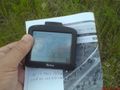
Inside the GPS's error pool.
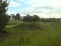
The area, including the 'forest' road used for car rallying.
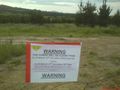
Rally warning sign at the road access.


