Difference between revisions of "2012-10-30 49 7"
imported>Triqueon |
imported>FippeBot m (Location) |
||
| (6 intermediate revisions by 4 users not shown) | |||
| Line 1: | Line 1: | ||
| − | + | {{advert}} | |
| − | {{ | ||
| − | |||
| − | |||
| − | |||
| − | |||
| − | |||
| − | |||
| − | |||
| − | |||
{{meetup graticule | {{meetup graticule | ||
| lat=49 | | lat=49 | ||
| Line 14: | Line 5: | ||
| date=2012-10-30 | | date=2012-10-30 | ||
}} | }} | ||
| + | |||
<!-- edit as necessary --> | <!-- edit as necessary --> | ||
| Line 39: | Line 31: | ||
As predicted, noone else was there, so we went home again promptly. | As predicted, noone else was there, so we went home again promptly. | ||
| − | |||
| − | |||
| − | |||
== Photos == | == Photos == | ||
| − | |||
| − | |||
| − | |||
<gallery perrow="5"> | <gallery perrow="5"> | ||
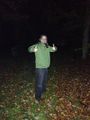
| + | Image:2012-10-30_49_7_photo-finish.jpg | Success! | ||
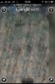
| + | Image:2012-10-30_49_7_screenshot.png | At last, some coordinates. | ||
</gallery> | </gallery> | ||
| Line 53: | Line 41: | ||
{{#vardefine:ribbonwidth|800px}} | {{#vardefine:ribbonwidth|800px}} | ||
<!-- Add any achievement ribbons you earned below, or remove this section --> | <!-- Add any achievement ribbons you earned below, or remove this section --> | ||
| − | |||
| − | |||
| − | |||
| − | |||
| − | |||
[[Category:Expeditions]] | [[Category:Expeditions]] | ||
[[Category:Expeditions with photos]] | [[Category:Expeditions with photos]] | ||
[[Category:Coordinates reached]] | [[Category:Coordinates reached]] | ||
| + | {{location|DE|SL|SB}} | ||
Latest revision as of 06:44, 13 August 2019
| Have you seen our geohashing marker? We'd love to hear from you! Click here to say "hi" and tell us what you've seen!
Curious about what geohashing is? Read more! |
| Tue 30 Oct 2012 in 49,7: 49.2965765, 7.0338569 geohashing.info google osm bing/os kml crox |
Location
In the woods, near an (apparent) water reservoir (TBC) between Dudweiler and Sulzbach.
Participants
Plans
We'll try to stop by at about 18:15 for a quick survey. We're not expecting to meet anyone, so will probably just walk by, get a picture, and leave.
Expedition
We arrived by car (just the two of us). Thankfully the way was either paved or at least very well visible, since we didn't have a torchlight with us and it was already pretty dark out. We took the path up until almost reaching the motorway, followed it for a bit, and arrived at the building Google Maps indicated us to be there.
From then, the usual fiddling with gadgets to confirm our location began. When we were satisfied with our accuracy, we left one of our marker sheets, took the screenshots below, and r007 took a picture of Triqueon for good measure.
As predicted, noone else was there, so we went home again promptly.
Photos
Success!
At last, some coordinates.

