Difference between revisions of "2012-11-09 49 -123"
imported>Jiml m (Fix result codes) |
imported>Wijnland (finished report) |
||
| Line 1: | Line 1: | ||
| − | + | [[Image:49-123_20121109_0114.jpg]] | |
| − | |||
| − | |||
| − | |||
| − | |||
| − | |||
| − | |||
{{meetup graticule | {{meetup graticule | ||
| lat=49 | | lat=49 | ||
| Line 24: | Line 18: | ||
== Participants == | == Participants == | ||
* [[User:Wijnland|Wijnland]] | * [[User:Wijnland|Wijnland]] | ||
| + | * Brendan | ||
== Plans == | == Plans == | ||
| Line 31: | Line 26: | ||
== Expedition == | == Expedition == | ||
Success! | Success! | ||
| + | I went with Brendan, of the UBC aqua society. I was quite a walk with all the dive gear and my camera etc. From shore is was about 50m swimming. To be sure we swam at the surface because the GPS does not have reception under water. At the Hash location we descended to the bottem which was at about 4 meter. The visibility was bad, you could barely see the outside of your mask. we swam a bit underwater, surfaced and than back to the parking, as we did not want to walk all the way again. | ||
| − | + | Interesting later part. I forgot my gps in the ziploc bag in my dive suit pocket, and found it there the week after. The bag had leaked and the gps was half full of salt water. I thought it was dead for sure, but took it apart, rinsed and dryed it anyways and except from one blank line in the screen it is still fully functional. :-) | |
| − | |||
== Photos == | == Photos == | ||
| − | |||
| − | |||
| − | |||
<gallery perrow="5"> | <gallery perrow="5"> | ||
| + | Image:49-123_20121109_0101.jpg | At the surface | ||
| + | Image:49-123_20121109_0100.jpg | At the surface, gps should be almost readable here... | ||
| + | Image:49-123_20121109_0105.jpg | Visibility below | ||
| + | Image:49-123_20121109_0093.jpg | GPS below... | ||
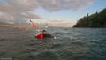
| + | Image:49-123_20121109_0114.jpg | Back up top, nice view | ||
| + | Image:49-123_20121109_0123.jpg | Prime view of the vancouver skyline | ||
</gallery> | </gallery> | ||
| Line 49: | Line 47: | ||
| date = 2012-11-09 | | date = 2012-11-09 | ||
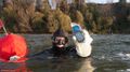
| name = [[User:Wijnland|Wijnland]] and Brendan | | name = [[User:Wijnland|Wijnland]] and Brendan | ||
| − | | image = | + | | image = 49-123_20121109_0100.jpg |
| equipment = Scubagear and Drysuits | | equipment = Scubagear and Drysuits | ||
}} | }} | ||
Revision as of 05:47, 3 December 2012

| Fri 9 Nov 2012 in 49,-123: 49.2769411, -123.2530882 geohashing.info google osm bing/os kml crox |
This one Simply has to be done! I will bring my scuba gear and try to get some other divers to join me, but it may be possible to just swim out. Or come witness and support this epic scuba geohash. I am on campus all day with my scubagear nearby, lets negotiate a time here! (evening will do too for me, but will need someone on shore then)
Location
Just of the shore at tower beach \ foreshore park (North UBC campus)
Participants
- Wijnland
- Brendan
Plans
I found another diver, we meet at 2 at the campus and will be at the geohash shortly after Wijnland 13:19, 9 November 2012 (EST)
Expedition
Success! I went with Brendan, of the UBC aqua society. I was quite a walk with all the dive gear and my camera etc. From shore is was about 50m swimming. To be sure we swam at the surface because the GPS does not have reception under water. At the Hash location we descended to the bottem which was at about 4 meter. The visibility was bad, you could barely see the outside of your mask. we swam a bit underwater, surfaced and than back to the parking, as we did not want to walk all the way again.
Interesting later part. I forgot my gps in the ziploc bag in my dive suit pocket, and found it there the week after. The bag had leaked and the gps was half full of salt water. I thought it was dead for sure, but took it apart, rinsed and dryed it anyways and except from one blank line in the screen it is still fully functional. :-)
Photos
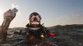
At the surface
At the surface, gps should be almost readable here...

Visibility below
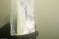
GPS below...
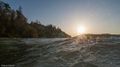
Back up top, nice view
Prime view of the vancouver skyline


Achievements
Wijnland and Brendan earned the Underwater geohash achievement
|