Difference between revisions of "2012-11-20 43 28"
From Geohashing
imported>Kisolre m |
imported>Kisolre (→Photos) |
||
| Line 35: | Line 35: | ||
Image:2012-11-20_43_28_15-51-09-212.jpg | Proof [http://www.openstreetmap.org/?lat=43.50418028&lon=28.30530826&zoom=16&layers=B000FTF @43.5042,28.3053] | Image:2012-11-20_43_28_15-51-09-212.jpg | Proof [http://www.openstreetmap.org/?lat=43.50418028&lon=28.30530826&zoom=16&layers=B000FTF @43.5042,28.3053] | ||
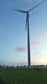
| + | Image:20121120 43 28 1.jpg | Wind turbine near the hash | ||
| + | Image:20121120 43 28 2.jpg | Forest patch near besides the field | ||
| + | Image:20121120 43 28 3.jpg | The field containing the hash | ||
| + | Image:20121120 43 28 4.jpg | Some info for future explorers :) | ||
| + | Image:20121120 43 28 5.jpg | Closer view. | ||
| + | Image:20121120 43 28 6.jpg | [[User:Kisolre|Kisolre]] at the hash. | ||
| + | Image:20121120 43 28 7.jpg | Another view of the wind turbine | ||
</gallery> | </gallery> | ||
Revision as of 14:19, 21 November 2012
| Tue 20 Nov 2012 in 43,28: 43.5041369, 28.3053059 geohashing.info google osm bing/os kml crox |
Location
In a field near Kavarna.
Participants
Kisolre and Vania
Plans
Location seemed reachable and also virgin graticule so too good to miss.
Expedition
Will fill later... probably...
Photos

Proof @43.5042,28.3053

Wind turbine near the hash

Forest patch near besides the field

The field containing the hash

Some info for future explorers :)

Closer view.

Kisolre at the hash.
Another view of the wind turbine


Achievements
Kisolre achieved level 2 of the Minesweeper Geohash achievement
|