Difference between revisions of "2012-11-22 43 27"
From Geohashing
imported>Kisolre (An expedition message sent via Geohash Droid for Android.) |
imported>FippeBot m (Location) |
||
| (4 intermediate revisions by one other user not shown) | |||
| Line 1: | Line 1: | ||
| − | |||
<!-- If you did not specify these parameters in the template, please substitute appropriate values for IMAGE, LAT, LON, and DATE (YYYY-MM-DD format) | <!-- If you did not specify these parameters in the template, please substitute appropriate values for IMAGE, LAT, LON, and DATE (YYYY-MM-DD format) | ||
| Line 18: | Line 17: | ||
__NOTOC__ | __NOTOC__ | ||
== Location == | == Location == | ||
| − | + | Near Conevo village in an empty field. | |
== Participants == | == Participants == | ||
| − | + | [[User:Kisolre | Kisolre]] and Vania | |
| − | |||
| − | |||
== Plans == | == Plans == | ||
| − | + | To visit a nearby dam and some [https://maps.google.com/maps/place?q=42.967985,27.292921&ftid=0x40a5dabf38985a29:0x1300a01231b2cdb0 stone formations]. | |
== Expedition == | == Expedition == | ||
<!-- how it all turned out. your narrative goes here. --> | <!-- how it all turned out. your narrative goes here. --> | ||
| − | |||
| − | |||
| − | |||
== Photos == | == Photos == | ||
| Line 38: | Line 32: | ||
--> | --> | ||
<gallery perrow="5"> | <gallery perrow="5"> | ||
| + | |||
| + | Image:2012-11-22_43_27_15-48-37-623.jpg | Proof [http://www.openstreetmap.org/?lat=43.03348413&lon=27.46194486&zoom=16&layers=B000FTF @43.0335,27.4619] | ||
</gallery> | </gallery> | ||
| Line 45: | Line 41: | ||
| − | |||
| − | |||
| − | |||
| − | |||
| − | |||
| − | |||
| − | |||
| − | |||
| − | |||
| − | |||
[[Category:Expeditions]] | [[Category:Expeditions]] | ||
| − | |||
[[Category:Expeditions with photos]] | [[Category:Expeditions with photos]] | ||
| − | |||
| − | |||
| − | |||
| − | |||
| − | |||
[[Category:Coordinates reached]] | [[Category:Coordinates reached]] | ||
| − | + | {{location|BG|B}} | |
| − | |||
| − | |||
| − | |||
| − | |||
| − | |||
| − | |||
| − | |||
| − | |||
| − | |||
| − | |||
| − | |||
| − | |||
| − | |||
| − | |||
| − | |||
| − | |||
| − | |||
Latest revision as of 06:57, 13 August 2019
| Thu 22 Nov 2012 in 43,27: 43.0334635, 27.4619523 geohashing.info google osm bing/os kml crox |
Location
Near Conevo village in an empty field.
Participants
Kisolre and Vania
Plans
To visit a nearby dam and some stone formations.
Expedition
Photos
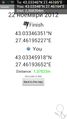
Proof @43.0335,27.4619
