Difference between revisions of "2012-11-30 29 -82"
imported>Grumpa (Created page with "{{subst:Expedition |lat = 29 |lon = -82 |date = 2012-11-30 }}") |
imported>FippeBot m (Location) |
||
| (10 intermediate revisions by 2 users not shown) | |||
| Line 1: | Line 1: | ||
| − | |||
<!-- If you did not specify these parameters in the template, please substitute appropriate values for IMAGE, LAT, LON, and DATE (YYYY-MM-DD format) | <!-- If you did not specify these parameters in the template, please substitute appropriate values for IMAGE, LAT, LON, and DATE (YYYY-MM-DD format) | ||
| Line 20: | Line 19: | ||
== Location == | == Location == | ||
<!-- where you've surveyed the hash to be --> | <!-- where you've surveyed the hash to be --> | ||
| + | Publically accessible land in the Florida Fish and Wildlife Conservation Commission's [http://myfwc.com/viewing/recreation/wmas/mitigation/watermelon-pond/ Watermelon Pond] | ||
== Participants == | == Participants == | ||
<!-- who attended: If you link to your wiki user name in this section, your expedition will be picked up by the various statistics generated for geohashing. You may use three tildes ~ as a shortcut to automatically insert the user signature of the account you are editing with. | <!-- who attended: If you link to your wiki user name in this section, your expedition will be picked up by the various statistics generated for geohashing. You may use three tildes ~ as a shortcut to automatically insert the user signature of the account you are editing with. | ||
--> | --> | ||
| + | [[User:Grumpa|Grumpa]] | ||
== Plans == | == Plans == | ||
<!-- what were the original plans --> | <!-- what were the original plans --> | ||
| + | I should be there around 2:00 pm. The aerial makes it look as if I can drive right on top of it but I'm betting those tracks are FWC vehicles and I'll have to park out on the road. | ||
== Expedition == | == Expedition == | ||
<!-- how it all turned out. your narrative goes here. --> | <!-- how it all turned out. your narrative goes here. --> | ||
| + | Those tracks on the aerial ''were'' from FWC vehicles (as well as fire breaks). But I never would have driven down the road anyway. In several areas the sugar sand would have swallowed my car up to the axels and I was alone and mostly in the middle of nowhere. Foolishness and carelessness don't mix. | ||
| + | |||
| + | It was a nice mile hike (round trip) in any case. With temperatures in the mid 70's there were just enough spots of shade to keep me comfortable. I brought along a hammer to pound the marker stake into the ground but left it in the car. If I came across a FWC officer I was well within my right to be there (it being a public area) but a lone male walking around carrying a hammer would possibly be suspicious. And a youth spent full of recorded indiscretion has a way of keeping me scrupulously within bounds these days. Then again, carrying around a wooden stake and a hammer enables the perfect excuse...vampires. | ||
| + | |||
| + | So, target reached I planted the stake in the sand and snapped a few pictures. I was well aware when I stepped off the trail that this was a perfect spot for the Eastern Diamondback Rattlesnake. I narrowly avoided a 6 footer a few years back and still haven't lost the respect gained in that episode. Those things are far better at hiding than I am at finding. And this time of year with the cool nights and sunny days can really bring them out. | ||
| + | |||
| + | It is a beautiful area and perhaps in the coming months I'll take the family out there. | ||
== Tracklog == | == Tracklog == | ||
| Line 39: | Line 48: | ||
--> | --> | ||
<gallery perrow="5"> | <gallery perrow="5"> | ||
| + | Image:2012-11-30_29_-82-01.jpg | Guess I'm hoofin' it. AND I get to climb a fence. | ||
| + | Image:2012-11-30_29_-82-02.jpg | According to the map it should be about half way across this clearing. | ||
| + | Image:2012-11-30_29_-82-03.jpg | A step forward. Two to the left. One step back Everybody now... | ||
| + | Image:2012-11-30_29_-82-04.jpg | Bingo. | ||
| + | Image:2012-11-30_29_-82-05.jpg | Marker. | ||
| + | Image:2012-11-30_29_-82-06.jpg | Marker. | ||
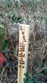
| + | Image:2012-11-30_29_-82-07.jpg | Just off the trail. A good place to hide a marker stake...and a rattlesnake. | ||
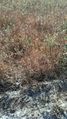
| + | Image:2012-11-30_29_-82-08.jpg | The nicest of days. | ||
| + | Image:2012-11-30_29_-82-09.jpg | I've never been out here before even though it is somewhat [http://www.google.com/search?q=Google+watermellon+pond=case notorious]. | ||
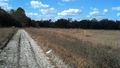
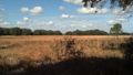
| + | Image:2012-11-30_29_-82-10.jpg | Another beautiful view. | ||
</gallery> | </gallery> | ||
| Line 44: | Line 63: | ||
{{#vardefine:ribbonwidth|800px}} | {{#vardefine:ribbonwidth|800px}} | ||
<!-- Add any achievement ribbons you earned below, or remove this section --> | <!-- Add any achievement ribbons you earned below, or remove this section --> | ||
| − | + | {{land geohash | latitude = 29 | longitude = -82 | date = 2012-11-30 | name = Grumpa }} | |
<!-- =============== USEFUL CATEGORIES FOLLOW ================ | <!-- =============== USEFUL CATEGORIES FOLLOW ================ | ||
Delete the next line ONLY if you have chosen the appropriate categories below. If you are unsure, don't worry. People will read your report and help you with the classification. --> | Delete the next line ONLY if you have chosen the appropriate categories below. If you are unsure, don't worry. People will read your report and help you with the classification. --> | ||
| − | |||
<!-- Potential categories. Please include all the ones appropriate to your expedition --> | <!-- Potential categories. Please include all the ones appropriate to your expedition --> | ||
| − | |||
| − | |||
| − | |||
| − | + | ||
[[Category:Expeditions]] | [[Category:Expeditions]] | ||
| − | |||
[[Category:Expeditions with photos]] | [[Category:Expeditions with photos]] | ||
| − | + | ||
| − | [[Category: | + | [[Category:Coordinates reached]] |
| − | + | {{location|US|FL|AL}} | |
| − | |||
| − | |||
| − | |||
| − | |||
| − | |||
| − | |||
| − | |||
| − | |||
| − | |||
| − | |||
| − | |||
| − | |||
| − | |||
| − | |||
| − | |||
| − | |||
| − | |||
| − | |||
| − | |||
| − | |||
| − | |||
Latest revision as of 00:04, 14 August 2019
| Fri 30 Nov 2012 in 29,-82: 29.5661283, -82.6142533 geohashing.info google osm bing/os kml crox |
Location
Publically accessible land in the Florida Fish and Wildlife Conservation Commission's Watermelon Pond
Participants
Plans
I should be there around 2:00 pm. The aerial makes it look as if I can drive right on top of it but I'm betting those tracks are FWC vehicles and I'll have to park out on the road.
Expedition
Those tracks on the aerial were from FWC vehicles (as well as fire breaks). But I never would have driven down the road anyway. In several areas the sugar sand would have swallowed my car up to the axels and I was alone and mostly in the middle of nowhere. Foolishness and carelessness don't mix.
It was a nice mile hike (round trip) in any case. With temperatures in the mid 70's there were just enough spots of shade to keep me comfortable. I brought along a hammer to pound the marker stake into the ground but left it in the car. If I came across a FWC officer I was well within my right to be there (it being a public area) but a lone male walking around carrying a hammer would possibly be suspicious. And a youth spent full of recorded indiscretion has a way of keeping me scrupulously within bounds these days. Then again, carrying around a wooden stake and a hammer enables the perfect excuse...vampires.
So, target reached I planted the stake in the sand and snapped a few pictures. I was well aware when I stepped off the trail that this was a perfect spot for the Eastern Diamondback Rattlesnake. I narrowly avoided a 6 footer a few years back and still haven't lost the respect gained in that episode. Those things are far better at hiding than I am at finding. And this time of year with the cool nights and sunny days can really bring them out.
It is a beautiful area and perhaps in the coming months I'll take the family out there.
Tracklog
Photos
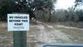
Guess I'm hoofin' it. AND I get to climb a fence.
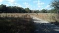
According to the map it should be about half way across this clearing.
A step forward. Two to the left. One step back Everybody now...
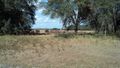
Bingo.
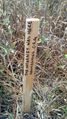
Marker.
Marker.
Just off the trail. A good place to hide a marker stake...and a rattlesnake.
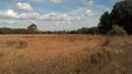
The nicest of days.
I've never been out here before even though it is somewhat notorious.
Another beautiful view.


Achievements
Grumpa earned the Land geohash achievement
|