Difference between revisions of "2012-07-22 49 -123"
From Geohashing
imported>Wijnland (Created page with "{{subst:Expedition |lat = 49 |lon = -123 |date = 2012-07-22 }}") |
imported>Wijnland (very late report, but great expedition) |
||
| Line 1: | Line 1: | ||
| + | [[Image:49-123_20120722_4.jpg]] | ||
| − | |||
| − | |||
| − | |||
| − | |||
| − | |||
| − | |||
| − | |||
| − | |||
{{meetup graticule | {{meetup graticule | ||
| lat=49 | | lat=49 | ||
| Line 18: | Line 11: | ||
__NOTOC__ | __NOTOC__ | ||
== Location == | == Location == | ||
| − | + | Up the sunshine coast | |
== Participants == | == Participants == | ||
| − | + | * [[User:Wijnland|Wijnland]] | |
| − | |||
| − | |||
| − | |||
== Expedition == | == Expedition == | ||
| − | + | We were at a camping and kajak weekend up the sunshine coast, near seachelt. Since it looked possible it had to be done. We started the day with 5 in cajaks, in the end two made it up the mountain to the geohash but all the party deserves full credit for the long boat ride and walk! and it was partly raining also. | |
| − | + | the route was: Kajak from lamb bay to about 2km past nine mile points, on the south side of salmon arm. Then up the mountain on foot and the same way back again. | |
| − | |||
== Photos == | == Photos == | ||
| − | + | ||
| − | + | ||
| − | |||
<gallery perrow="5"> | <gallery perrow="5"> | ||
| + | Image:49-123_20120722_9084.jpg | Kajak | ||
| + | Image:49-123_20120722_9122.jpg | Location reached | ||
| + | Image:49-123_20120722_9125.jpg | Grin | ||
| + | Image:49-123_20120722_9126.jpg | The View | ||
| + | Image:49-123_20120722_9111.jpg | Swamp | ||
</gallery> | </gallery> | ||
| − | |||
| − | |||
| − | |||
| − | + | ||
| − | |||
[[Category:New report]] | [[Category:New report]] | ||
| + | [[Category:Expeditions with photos]] | ||
| − | |||
| − | |||
| − | |||
| − | |||
| − | |||
| − | |||
| − | |||
| − | |||
| − | |||
| − | |||
| − | |||
| − | |||
| − | |||
| − | |||
[[Category:Coordinates reached]] | [[Category:Coordinates reached]] | ||
| − | |||
| − | |||
| − | |||
| − | |||
| − | |||
| − | |||
| − | |||
| − | |||
| − | |||
| − | |||
| − | |||
| − | |||
| − | |||
| − | |||
| − | |||
| − | |||
| − | |||
| − | |||
Revision as of 06:15, 3 December 2012

| Sun 22 Jul 2012 in 49,-123: 49.5994754, -123.7209116 geohashing.info google osm bing/os kml crox |
Location
Up the sunshine coast
Participants
Expedition
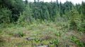
We were at a camping and kajak weekend up the sunshine coast, near seachelt. Since it looked possible it had to be done. We started the day with 5 in cajaks, in the end two made it up the mountain to the geohash but all the party deserves full credit for the long boat ride and walk! and it was partly raining also.
the route was: Kajak from lamb bay to about 2km past nine mile points, on the south side of salmon arm. Then up the mountain on foot and the same way back again.
Photos
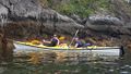
Kajak
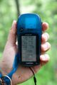
Location reached
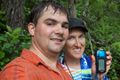
Grin
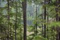
The View
Swamp


