Difference between revisions of "2012-12-12 33 -117"
From Geohashing
imported>LucasBrown |
imported>FippeBot m (Location) |
||
| (3 intermediate revisions by 2 users not shown) | |||
| Line 3: | Line 3: | ||
__NOTOC__ | __NOTOC__ | ||
== Location == | == Location == | ||
| − | + | On a hillside west of College Boulevard, east of Masterpiece Drive, south of Frazee Road, and north of Chroma Drive in Oceanside, CA | |
== Participants == | == Participants == | ||
| Line 13: | Line 13: | ||
Image:2012-12-12_33_-117_13-49-40-801.jpg | Map at the hashpoint [http://www.openstreetmap.org/?lat=33.23164605&lon=-117.29450960&zoom=16&layers=B000FTF @33.2316,-117.2945] | Image:2012-12-12_33_-117_13-49-40-801.jpg | Map at the hashpoint [http://www.openstreetmap.org/?lat=33.23164605&lon=-117.29450960&zoom=16&layers=B000FTF @33.2316,-117.2945] | ||
Image:2012-12-12_33_-117_13-50-17-158.jpg | Zoomed-out map at the hashpoint [http://www.openstreetmap.org/?lat=33.23164860&lon=-117.29451008&zoom=16&layers=B000FTF @33.2316,-117.2945] | Image:2012-12-12_33_-117_13-50-17-158.jpg | Zoomed-out map at the hashpoint [http://www.openstreetmap.org/?lat=33.23164860&lon=-117.29451008&zoom=16&layers=B000FTF @33.2316,-117.2945] | ||
| + | Image:2012-12-12_33_-117_pano.jpg | Panorama looking northeast from the hashpoint | ||
</gallery> | </gallery> | ||
| − | |||
[[Category:Expeditions]] | [[Category:Expeditions]] | ||
[[Category:Expeditions with photos]] | [[Category:Expeditions with photos]] | ||
[[Category:Expedition without GPS]] | [[Category:Expedition without GPS]] | ||
[[Category:Coordinates reached]] | [[Category:Coordinates reached]] | ||
| + | {{location|US|CA|SD}} | ||
Latest revision as of 00:11, 14 August 2019
| Wed 12 Dec 2012 in 33,-117: 33.2316550, -117.2945172 geohashing.info google osm bing/os kml crox |
Location
On a hillside west of College Boulevard, east of Masterpiece Drive, south of Frazee Road, and north of Chroma Drive in Oceanside, CA
Participants
Photos
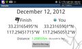
Geohash Droid details page at the hashpoint @33.2316,-117.2945
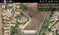
Map at the hashpoint @33.2316,-117.2945
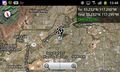
Zoomed-out map at the hashpoint @33.2316,-117.2945
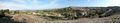
Panorama looking northeast from the hashpoint


