Difference between revisions of "2012-12-28 62 27"
imported>Tilley m |
imported>Tilley m |
||
| Line 6: | Line 6: | ||
__NOTOC__ | __NOTOC__ | ||
== Location == | == Location == | ||
| − | + | In Kuopio, Savolanniemi peninsula, near a radio mast used by the military. | |
== Participants == | == Participants == | ||
| Line 17: | Line 17: | ||
== Plans == | == Plans == | ||
| − | I was coming back with my wife and daughter from spending Christmas in my parent's place in Valtimo, and dutifully checked the hashpoints for the three graticules we were driving through. To my surprise I noticed, that the hashpoint for our home graticule was only 3,6 km from our coach! This point we definitely have to visit, there's no excuse! There's also a chance to get quite a crowd to the hashpoint this time, as the weather is now suitable for the baby (only -8°C), and my brother and her wife are visiting us in the afternoon, maybe we can drag them along, too. | + | [[File:2012-12-28_62_27_Geohash_Kuopio_Karttapaikka.png|150px|thumb|left|Map of the hashpoint]]I was coming back with my wife and daughter from spending Christmas in my parent's place in Valtimo, and dutifully checked the hashpoints for the three graticules we were driving through. To my surprise I noticed, that the hashpoint for our home graticule was only 3,6 km from our coach! This point we definitely have to visit, there's no excuse! There's also a chance to get quite a crowd to the hashpoint this time, as the weather is now suitable for the baby (only -8°C), and my brother and her wife are visiting us in the afternoon, maybe we can drag them along, too. |
== Expedition == | == Expedition == | ||
Revision as of 19:10, 29 December 2012
| Fri 28 Dec 2012 in 62,27: 62.8227936, 27.7009917 geohashing.info google osm bing/os kml crox |
Location
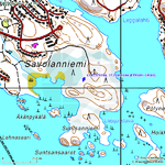
In Kuopio, Savolanniemi peninsula, near a radio mast used by the military.
Participants
- Tilley
- Mrs. Tilley
- Tilley's daughter, 37 days
- Tilley's brother
- brother's wife.
Plans
I was coming back with my wife and daughter from spending Christmas in my parent's place in Valtimo, and dutifully checked the hashpoints for the three graticules we were driving through. To my surprise I noticed, that the hashpoint for our home graticule was only 3,6 km from our coach! This point we definitely have to visit, there's no excuse! There's also a chance to get quite a crowd to the hashpoint this time, as the weather is now suitable for the baby (only -8°C), and my brother and her wife are visiting us in the afternoon, maybe we can drag them along, too.
Expedition
My brother and his wife were supportive of the idea of going to the geohash. So we packed a camera, a gps device, the xkcd-marker-paper, a few flashlights and the baby (she was the only of the above-mentioned to protest the packing) and set out. We drove through the suburbs and nearing the hashpoint located quickly the nearest place to leave our vehicle. As though the road to the radio mast was ploughed, there was a sign "no motorized vehicles". The baby was currently sleeping, so we didn't take her out of her safety crib, but proceeded on foot carrying the baby.
After walking about 400 meters we were almost at the radio mast, and our gps arrow pointing to the hash point started to veer off to the right. It was time to go off road. There was some 30 cm of loose snow in the forest, which made it difficult see where to set foot, as the ground was quite uneven. The darkness was not complete, as the lights of the nearby settlements reflected from the cloud cover and snow. I myself ploughed ahead with the crib of the baby in one hand and gps in the other, the rest of gang following behind. My brother and his wife didn't know beforehand that they were going to trek in a dark snowy forest as a part of their visit, so they of course didn't have that much of a outdoor-oriented attire, or most importantly, footwear. (Have to wait for a few months for that hobbit achievement...)
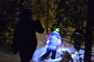
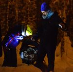
After about 70 meters of trudging in the forest we located the hashpoint, and stopped to take the group photo. Baby protested stopping, so we didn't have much time to set out the "perfect" shot, for example the baby itself is almost unseeable in the picture, so you just have to trust me a little bit here. Anyways she was so deeply buried to her way-too-big winter coverall you had to look very carefully to even see her on the spot, as you can see left in the other picture, when my wife is checking that everything is ok.
After a few minutes on the hash we left. And of course forgot to leave our xkcd marker we had prepared beforehand. Well, that patch of forest did not seem to be traversed very often, maybe the nearby residents go pick some blueberries and mushrooms there in summer, but the unprotected paper probably wouldn't have lasted that long anyway. Following our own trail we found our way back to the road and soon were back at the civilization.
Additional photos
Achievements
Tilley's daughter earned the Frozen baby Achievement
|
Tilley and Mrs. Tilley earned the Youngest Geohash honourable mention
|


