Difference between revisions of "1977-02-25 42 -90"
imported>Swensonj (start page) |
imported>FippeBot m (Location) |
||
| (14 intermediate revisions by 3 users not shown) | |||
| Line 1: | Line 1: | ||
| + | {| class="wikitable" | ||
| + | |- | ||
| + | | [[File:2013-01-05_42_-90 DoubleMap.PNG|400px|thumb|left|Map of both hashpoints]] | ||
| + | | {{meetup graticule | ||
| + | | lat=42 | ||
| + | | lon=-90 | ||
| + | | date=1977-02-25 | ||
| + | | retro=1 | ||
| + | }} | ||
| + | |} | ||
| − | |||
| − | |||
| − | |||
| − | |||
| − | |||
| − | |||
| − | |||
| − | |||
| − | |||
| − | |||
| − | |||
| − | |||
| − | |||
| − | |||
| − | |||
| − | |||
__NOTOC__ | __NOTOC__ | ||
== Location == | == Location == | ||
| − | + | Off County Road N, east of Beetown, Wisconsin, about a mile south of [[2013-01-05 42 -90]]. | |
== Participants == | == Participants == | ||
| − | + | [[User:Swensonj|SwensonJ]] and kids | |
| − | |||
== Plans == | == Plans == | ||
| − | + | I'll try to visit this one on my way to an XKCD meetup at [[2013-01-05 42 -90]]. | |
| + | |||
| + | (Update: we got a late start, and didn't get there until after the 4pm hash.) | ||
== Expedition == | == Expedition == | ||
| − | + | This is part two of a pseudomultihash: you can also read about [[2013-01-05 42 -90|part one]]. | |
| + | |||
| + | It took about five minutes to reprogram the GPS and drive around to the road nearest to the retrohashpoint. Two kids who lived on the farm in question were in the dooryard doing some sort of chores. I stopped to ask if it would be all right to walk across their fields; while I was trying to get the question across, their dad popped out the back door, and I had to explain it all again. He was glad enough to agree. Their two dogs were very interested in my kids and me; we played a little bit, but moved on quickly because we knew it would start getting dark quickly. | ||
| + | |||
| + | This time, we all put on our snowshoes. It was a significant walk: about a quarter of a mile over rolling ground, over the snow drifts, alongside a small creek. The temperature was somewhat above freezing, though, and there was no wind, so it was a pleasant adventure. About three quarters of the way to our destination, we were stalled by a barbed-wire fence: I managed to step over it, then lift both kids across. This is not terribly easy when one is wearing snowshoes! | ||
| − | + | We walked another 100m or so to a nice old tree, by itself on top of a ridge, then straight west down to the bottom of a valley. For the second time in the day, the exact GPS coordinates came in almost immediately, and I had no trouble getting the requisite proof photo. Maybe I'm getting good at this? No -- probably it was just random luck. | |
| − | + | ||
| + | We took a quick rest, and a few photos, but the light was fading fast. The trip back was slower: we were getting tired and hungry, but the kids did a great job of staying positive. I passed some nervous moments, because for a long time, as we got close to the starting point, I couldn't see my van on the roadside where we'd left it. Eventually, though, I picked it out of the shadows, and was able to relax. We stripped off our snowshoes, buckled ourselves into the van, and broke out a thermos of hot chocolate. We were all glad we'd made the trip. | ||
| + | |||
| + | We got back on the road about 5:45 p.m., and headed into the nearby town of Lancaster, which has a McDonald's with a PlayPlace. The kids still had plenty of energy to climb and slide in the play structure, while I relaxed and warmed up in a more passive way. I tried the new Grilled Onion and Cheddar sandwich; it wasn't bad. I had to hurry the kids out of the PlayPlace so we could all be home in time to see my Vikings in a playoff game against the hated rival Packers. (For my friends outside the United States: we are talking about American football here.) In hindsight, it would have been fine to miss it. The game was over long before it was over, which is too bad, but at least it gave me some extra time to work on this nice long writeup. | ||
== Photos == | == Photos == | ||
| − | |||
| − | |||
| − | |||
<gallery perrow="5"> | <gallery perrow="5"> | ||
| + | Image:1977-02-25 42 -90 Calf.jpg | My kids were very happy to see calves... | ||
| + | Image:1977-02-25 42 -90 Horse.jpg | ...and horses. | ||
| + | Image:1977-02-25 42 -90 Host.jpg | This young man lives at the hash; his dad gave us permission to walk across the fields. | ||
| + | Image:1977-02-25 42 -90 Neighbor.jpg | The neighboring farm to the west. | ||
| + | Image:1977-02-25 42 -90 Rest.jpg | My son rests near the hashpoint. | ||
| + | Image:1977-02-25 42 -90 Tree.jpg | This tree is almost at the end of our trip. | ||
| + | Image:1977-02-25 42 -90 Proof.jpg | We got to the right place... | ||
| + | Image:1977-02-25 42 -90 Grin.jpg | ...and I was happy there... | ||
| + | Image:1977-02-25 42 -90 Kids.jpg | ...as were my kids. | ||
| + | Image:1977-02-25 42 -90 Hash.jpg | This is the view from the hashpoint. | ||
</gallery> | </gallery> | ||
| Line 44: | Line 53: | ||
<!-- Add any achievement ribbons you earned below, or remove this section --> | <!-- Add any achievement ribbons you earned below, or remove this section --> | ||
| + | {{Displaced origin geohash | ||
| + | | birthlatitude = 44 | ||
| + | | birthlongitude = -93 | ||
| + | | birthdate = 1977-02-25 | ||
| + | | on = 2013-01-05 | ||
| + | | attemptlatitude = 42 | ||
| + | | attemptlongitude = -90 | ||
| + | | name = [[User:Swensonj|SwensonJ]] | ||
| + | | image = 1977-02-25_42_-90 Proof.jpg | ||
| + | }} | ||
| + | {{gratuitous ribbon | ||
| + | | icon = Multihash.png | ||
| + | | latitude = 42 | ||
| + | | longitude = -90 | ||
| + | | date = 2013-01-05 | ||
| + | | achievement = Pseudomultihash achievement | ||
| + | | description = visiting the retrohash [[1977-02-25 42 -90]] and the | ||
| + | | name = [[User:Swensonj|SwensonJ]] | ||
| + | }} | ||
| − | |||
| − | |||
| − | |||
| − | |||
| − | |||
| − | |||
| − | |||
| − | |||
| − | |||
| − | |||
| − | |||
| − | |||
[[Category:Expeditions with photos]] | [[Category:Expeditions with photos]] | ||
| − | [[Category: | + | [[Category:Retro coordinates reached]] |
| − | + | {{location|US|WI|GA}} | |
| − | |||
| − | |||
| − | |||
| − | |||
| − | |||
| − | |||
| − | |||
| − | |||
| − | |||
| − | |||
| − | |||
| − | |||
| − | |||
| − | |||
| − | |||
| − | |||
| − | |||
| − | |||
| − | |||
| − | |||
| − | |||
| − | |||
Latest revision as of 03:48, 7 August 2019
| |||||||

Location
Off County Road N, east of Beetown, Wisconsin, about a mile south of 2013-01-05 42 -90.
Participants
SwensonJ and kids
Plans
I'll try to visit this one on my way to an XKCD meetup at 2013-01-05 42 -90.
(Update: we got a late start, and didn't get there until after the 4pm hash.)
Expedition
This is part two of a pseudomultihash: you can also read about part one.
It took about five minutes to reprogram the GPS and drive around to the road nearest to the retrohashpoint. Two kids who lived on the farm in question were in the dooryard doing some sort of chores. I stopped to ask if it would be all right to walk across their fields; while I was trying to get the question across, their dad popped out the back door, and I had to explain it all again. He was glad enough to agree. Their two dogs were very interested in my kids and me; we played a little bit, but moved on quickly because we knew it would start getting dark quickly.
This time, we all put on our snowshoes. It was a significant walk: about a quarter of a mile over rolling ground, over the snow drifts, alongside a small creek. The temperature was somewhat above freezing, though, and there was no wind, so it was a pleasant adventure. About three quarters of the way to our destination, we were stalled by a barbed-wire fence: I managed to step over it, then lift both kids across. This is not terribly easy when one is wearing snowshoes!
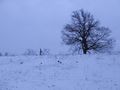
We walked another 100m or so to a nice old tree, by itself on top of a ridge, then straight west down to the bottom of a valley. For the second time in the day, the exact GPS coordinates came in almost immediately, and I had no trouble getting the requisite proof photo. Maybe I'm getting good at this? No -- probably it was just random luck.
We took a quick rest, and a few photos, but the light was fading fast. The trip back was slower: we were getting tired and hungry, but the kids did a great job of staying positive. I passed some nervous moments, because for a long time, as we got close to the starting point, I couldn't see my van on the roadside where we'd left it. Eventually, though, I picked it out of the shadows, and was able to relax. We stripped off our snowshoes, buckled ourselves into the van, and broke out a thermos of hot chocolate. We were all glad we'd made the trip.
We got back on the road about 5:45 p.m., and headed into the nearby town of Lancaster, which has a McDonald's with a PlayPlace. The kids still had plenty of energy to climb and slide in the play structure, while I relaxed and warmed up in a more passive way. I tried the new Grilled Onion and Cheddar sandwich; it wasn't bad. I had to hurry the kids out of the PlayPlace so we could all be home in time to see my Vikings in a playoff game against the hated rival Packers. (For my friends outside the United States: we are talking about American football here.) In hindsight, it would have been fine to miss it. The game was over long before it was over, which is too bad, but at least it gave me some extra time to work on this nice long writeup.
Photos
My kids were very happy to see calves...
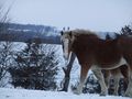
...and horses.
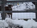
This young man lives at the hash; his dad gave us permission to walk across the fields.
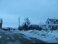
The neighboring farm to the west.
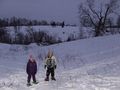
My son rests near the hashpoint.
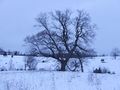
This tree is almost at the end of our trip.
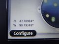
We got to the right place...
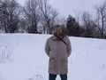
...and I was happy there...
...as were my kids.
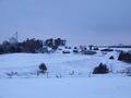
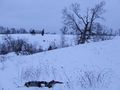
This is the view from the hashpoint.


Achievements
SwensonJ earned the Displaced origin geohash achievement
|
SwensonJ earned the Pseudomultihash achievement
|