Difference between revisions of "2013-01-05 43 -116"
imported>Eldin (→Achievements) |
imported>FippeBot m (Location) |
||
| (7 intermediate revisions by 2 users not shown) | |||
| Line 1: | Line 1: | ||
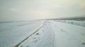
| + | [[File:2013-01-05 43 -116 pic1.jpg|thumb|left|Snow-covered desert, looking west from hash point.]] | ||
| − | |||
| − | |||
| − | |||
| − | |||
| − | |||
| − | |||
| − | |||
| − | |||
| − | |||
{{meetup graticule | {{meetup graticule | ||
| lat=43 | | lat=43 | ||
| Line 15: | Line 7: | ||
}} | }} | ||
| − | + | ||
__NOTOC__ | __NOTOC__ | ||
== Location == | == Location == | ||
| − | + | ||
Northwest of Caldwell, near the Sand Hollow interchange on I-84 | Northwest of Caldwell, near the Sand Hollow interchange on I-84 | ||
== Participants == | == Participants == | ||
| − | + | ||
| − | + | * [[User:Eldin | Eldin]] | |
== Plans == | == Plans == | ||
| − | + | ||
| + | I've been wanting to try geohashing for a while, and today things lined up so I had free time, | ||
| + | and the geohash looked like it would be accessible. | ||
== Expedition == | == Expedition == | ||
| − | |||
*I'm at the hash point it's really cold so do a full write up when I get back somewhere warm -- [[User:Eldin|Eldin]] [http://www.openstreetmap.org/?lat=43.80085085&lon=-116.78848847&zoom=16&layers=B000FTF @43.8009,-116.7885] 18:36, 5 January 2013 (EST) | *I'm at the hash point it's really cold so do a full write up when I get back somewhere warm -- [[User:Eldin|Eldin]] [http://www.openstreetmap.org/?lat=43.80085085&lon=-116.78848847&zoom=16&layers=B000FTF @43.8009,-116.7885] 18:36, 5 January 2013 (EST) | ||
| − | + | ||
| − | + | *Ok, I'm someplace warmer now, so here's the more complete write-up. | |
| + | |||
| + | The geohash was just off of a narrow dirt road running between an irrigation canal and a plowed field. Missed the dirt road turn off the first time and had to go back. About half a mile down, road (really more like a couple ruts than a real road) narrowed down to a single lane with no room to turn around, so I was committed to pushing on at that point. Fortunately, the map showing the road as a loop was accurate. I'd have hated to back out of that. | ||
| + | |||
| + | I was able to drive to within 20ft of the geohash location. I arrived at approximately 4:30pm, and the thermometer in my car read 12°F. Weather info on my phone said 9°F, and it felt colder than that with the wind blowing. Actual location was about half way down a slippery slope, so while I was able to slide across it, I was actually standing about 11ft away when I took pictures and posted my initial comment while onsite. In spite of the cold and the unpleasant "road", I did enjoy myself. I'll definitely be doing this again. | ||
| + | |||
| + | Note: My phone was both the only camera and only GPS device I had, so I didn't get a picture of the GPS screen. However, the photo of me has geotagging information embedded in it by my phone, so I submit that as my only proof that I was in the right place. It contains the following tag: | ||
| + | |||
| + | GPS Position : 43 deg 48' 3.00" N, 116 deg 47' 19.00" W | ||
| + | |||
| + | which matches the location of the geohash to within the 1 arc-second resolution of the tag. | ||
== Photos == | == Photos == | ||
| − | + | ||
| − | |||
| − | |||
<gallery perrow="5"> | <gallery perrow="5"> | ||
| + | Image:2013-01-05 43 -116 Eldin.jpg | Me standing in front of the hashpoint. | ||
| + | Image:2013-01-05 43 -116 .pic2.jpg | The snow covered single lane dirt road that got me here. | ||
</gallery> | </gallery> | ||
== Achievements == | == Achievements == | ||
{{#vardefine:ribbonwidth|800px}} | {{#vardefine:ribbonwidth|800px}} | ||
| − | |||
| − | [[ | + | {{land geohash |
| + | |||
| + | | latitude = 43 | ||
| + | | longitude = -116 | ||
| + | | date = 2013-01-05 | ||
| + | | name = [[User:Eldin | Eldin]] | ||
| + | }} | ||
| + | {{Frozen Geohash | ||
| + | |||
| + | | latitude = 43 | ||
| + | | longitude = -116 | ||
| + | | date = 2013-01-05 | ||
| + | | temperature = 12 °F | ||
| + | | name = [[User:Eldin | Eldin]] | ||
| + | |||
| + | }} | ||
| + | |||
[[Category:Expeditions]] | [[Category:Expeditions]] | ||
[[Category:Expeditions with photos]] | [[Category:Expeditions with photos]] | ||
[[Category:Coordinates reached]] | [[Category:Coordinates reached]] | ||
| + | {{location|US|ID|PA}} | ||
Latest revision as of 00:31, 14 August 2019

| Sat 5 Jan 2013 in 43,-116: 43.8008605, -116.7884382 geohashing.info google osm bing/os kml crox |
Location
Northwest of Caldwell, near the Sand Hollow interchange on I-84
Participants
Plans
I've been wanting to try geohashing for a while, and today things lined up so I had free time, and the geohash looked like it would be accessible.
Expedition
- I'm at the hash point it's really cold so do a full write up when I get back somewhere warm -- Eldin @43.8009,-116.7885 18:36, 5 January 2013 (EST)
- Ok, I'm someplace warmer now, so here's the more complete write-up.
The geohash was just off of a narrow dirt road running between an irrigation canal and a plowed field. Missed the dirt road turn off the first time and had to go back. About half a mile down, road (really more like a couple ruts than a real road) narrowed down to a single lane with no room to turn around, so I was committed to pushing on at that point. Fortunately, the map showing the road as a loop was accurate. I'd have hated to back out of that.
I was able to drive to within 20ft of the geohash location. I arrived at approximately 4:30pm, and the thermometer in my car read 12°F. Weather info on my phone said 9°F, and it felt colder than that with the wind blowing. Actual location was about half way down a slippery slope, so while I was able to slide across it, I was actually standing about 11ft away when I took pictures and posted my initial comment while onsite. In spite of the cold and the unpleasant "road", I did enjoy myself. I'll definitely be doing this again.
Note: My phone was both the only camera and only GPS device I had, so I didn't get a picture of the GPS screen. However, the photo of me has geotagging information embedded in it by my phone, so I submit that as my only proof that I was in the right place. It contains the following tag:
GPS Position : 43 deg 48' 3.00" N, 116 deg 47' 19.00" W
which matches the location of the geohash to within the 1 arc-second resolution of the tag.
Photos

Me standing in front of the hashpoint.
The snow covered single lane dirt road that got me here.


Achievements
Eldin earned the Land geohash achievement
|
Eldin earned the Frozen Geohash Achievement
|