Difference between revisions of "2013-01-08 60 24"
imported>Vyznev (OK, did I get this more or less right?) |
imported>FippeBot m (Location) |
||
| (2 intermediate revisions by 2 users not shown) | |||
| Line 1: | Line 1: | ||
| − | |||
| − | |||
| − | |||
| − | |||
| − | |||
| − | |||
| − | |||
| − | |||
| − | |||
{{meetup graticule | {{meetup graticule | ||
| lat=60 | | lat=60 | ||
| Line 13: | Line 4: | ||
| date=2013-01-08 | | date=2013-01-08 | ||
}} | }} | ||
| − | |||
| − | |||
__NOTOC__ | __NOTOC__ | ||
== Location == | == Location == | ||
| Line 24: | Line 13: | ||
== Expedition == | == Expedition == | ||
| − | |||
| − | |||
*At geohash. -- [[User:Kmk|Kmk]] [http://www.openstreetmap.org/?lat=60.18677061&lon=24.91869062&zoom=16&layers=B000FTF @60.1868,24.9187] 05:39, 8 January 2013 (EST) | *At geohash. -- [[User:Kmk|Kmk]] [http://www.openstreetmap.org/?lat=60.18677061&lon=24.91869062&zoom=16&layers=B000FTF @60.1868,24.9187] 05:39, 8 January 2013 (EST) | ||
| Line 33: | Line 20: | ||
After looking at the bus routes on the route planner, I also realized that I hadn't crossed my own path while coming to work, so I could attempt the [[Tron achievement]]. (As I understand it, stopping in a building and crossing my path while inside doesn't count.) I'd already walked right past the nearest bus stop, though, so I had to make a small detour through the woods to another stop. | After looking at the bus routes on the route planner, I also realized that I hadn't crossed my own path while coming to work, so I could attempt the [[Tron achievement]]. (As I understand it, stopping in a building and crossing my path while inside doesn't count.) I'd already walked right past the nearest bus stop, though, so I had to make a small detour through the woods to another stop. | ||
| − | Finding the actual hashpoint wasn't particularly difficult, even from memory. I looked for signs of any earlier visitors (didn't spot any), wrote "XKCD" in the snow and took some pictures. Didn't remember to make a [[Snowman Geohash|snowman]], though. On the way back, I took a tram to the city center, stopped to buy some groceries and took another bus home. For a final twist, I dozed off in the bus and ended up missing my stop. I wasn't sure if taking another bus back along the same road would be enough to disqualify me from the Tron achievement, so I decided to walk home along some small footpaths instead, which would've been quite pleasant if I hadn't been carrying a ridiculously heavy bag of groceries | + | Finding the actual hashpoint wasn't particularly difficult, even from memory. I looked for signs of any earlier visitors (didn't spot any), wrote "XKCD" in the snow and took some pictures. Didn't remember to make a [[Snowman Geohash|snowman]], though. On the way back, I took a tram to the city center, stopped to buy some groceries and took another bus home. For a final twist, I dozed off in the bus and ended up missing my stop. I wasn't sure if taking another bus back along the same road would be enough to disqualify me from the Tron achievement, so I decided to walk home along some small footpaths instead, which would've been quite pleasant if I hadn't been carrying a ridiculously heavy bag of groceries with me. |
I was hoping to get the [[Frozen Geohash]] achievement too, but I didn't have a thermometer with me, and the temperature recorded at the closest weather station at the time I visited the hashpoint was just around 0 °C, so I can't really be sure. | I was hoping to get the [[Frozen Geohash]] achievement too, but I didn't have a thermometer with me, and the temperature recorded at the closest weather station at the time I visited the hashpoint was just around 0 °C, so I can't really be sure. | ||
== Photos == | == Photos == | ||
| − | < | + | <gallery> |
| − | |||
| − | |||
| − | |||
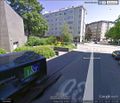
File:GeoHash 2013-01-08 60 24 Google Street View screenshot 1.jpeg | Virtual view of the hashpoint from the northwest along Minna Canthin katu on Google Street View | File:GeoHash 2013-01-08 60 24 Google Street View screenshot 1.jpeg | Virtual view of the hashpoint from the northwest along Minna Canthin katu on Google Street View | ||
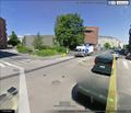
File:GeoHash 2013-01-08 60 24 Google Street View screenshot 2.jpeg | Virtual view of the hashpoint from the south across the street crossing on Google Street View | File:GeoHash 2013-01-08 60 24 Google Street View screenshot 2.jpeg | Virtual view of the hashpoint from the south across the street crossing on Google Street View | ||
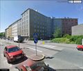
File:GeoHash 2013-01-08 60 24 Google Street View screenshot 3.jpeg | Virtual view of the hashpoint from the northeast across Nordenskiöldinkatu on Google Street View | File:GeoHash 2013-01-08 60 24 Google Street View screenshot 3.jpeg | Virtual view of the hashpoint from the northeast across Nordenskiöldinkatu on Google Street View | ||
| − | File:GeoHash 2013-01-08 60 24 photo 001.jpeg | Heading towards the hashpoint on bus 506 | + | File:GeoHash 2013-01-08 60 24 photo 001.jpeg | Heading towards the hashpoint on bus 506 |
| + | File:GeoHash 2013-01-08 60 24 photo 008.jpeg | Walked past this nice Czech pub on the way to the hashpoint | ||
| + | File:GeoHash 2013-01-08 60 24 photo 009.jpeg | Found the right street | ||
| + | File:GeoHash 2013-01-08 60 24 photo 014.jpeg | There it is! | ||
| + | File:GeoHash 2013-01-08 60 24 photo 018.jpeg | As far as I could determine from Google Maps, this "no parking" sign may have been situated just about on top of the hashpoint | ||
| + | File:GeoHash 2013-01-08 60 24 photo 025.jpeg | A view from the other side | ||
| + | File:GeoHash 2013-01-08 60 24 photo 026.jpeg | Left a mark in the snow for passers-by to wonder about | ||
| + | File:GeoHash 2013-01-08 60 24 photo 028.jpeg | The buildings next to the hashpoint are apparently a part of [[wikipedia:Alvar Aalto|Finnish architectural history]] | ||
| + | File:GeoHash 2013-01-08 60 24 photo 032.jpeg | Travel card reader in the tram, on the way from the hashpoint to the city center | ||
| + | File:GeoHash 2013-01-08 60 24 photo 036.jpeg | In bus 68, on the way back home | ||
File:GeoHash 2013-01-08 60 24 Google Earth route screenshot.png | Reconstructed route, demonstrating Tron achievement | File:GeoHash 2013-01-08 60 24 Google Earth route screenshot.png | Reconstructed route, demonstrating Tron achievement | ||
File:GeoHash 2013-01-08 60 24 Foreca weather Kaisaniemi.png | Temperature peaked at just barely above 0 °C, so no frozen geohash | File:GeoHash 2013-01-08 60 24 Foreca weather Kaisaniemi.png | Temperature peaked at just barely above 0 °C, so no frozen geohash | ||
| Line 52: | Line 45: | ||
== Achievements == | == Achievements == | ||
{{#vardefine:ribbonwidth|800px}} | {{#vardefine:ribbonwidth|800px}} | ||
| − | |||
{{Land geohash|latitude=60|longitude=24|date=2013-01-08|name=[[User:Vyznev|Vyznev]]}} | {{Land geohash|latitude=60|longitude=24|date=2013-01-08|name=[[User:Vyznev|Vyznev]]}} | ||
{{No batteries geohash|latitude=60|longitude=24|date=2013-01-08|name=[[User:Vyznev|Vyznev]]}} | {{No batteries geohash|latitude=60|longitude=24|date=2013-01-08|name=[[User:Vyznev|Vyznev]]}} | ||
{{Public transport geohash|latitude=60|longitude=24|date=2013-01-08|name=[[User:Vyznev|Vyznev]]}} | {{Public transport geohash|latitude=60|longitude=24|date=2013-01-08|name=[[User:Vyznev|Vyznev]]}} | ||
{{Tron|latitude=60|longitude=24|date=2013-01-08|name=[[User:Vyznev|Vyznev]]|possessive=his|tracklog={{fullurl:File:GeoHash_2013-01-08_60_24_Google_Earth_route_screenshot.png}}}} | {{Tron|latitude=60|longitude=24|date=2013-01-08|name=[[User:Vyznev|Vyznev]]|possessive=his|tracklog={{fullurl:File:GeoHash_2013-01-08_60_24_Google_Earth_route_screenshot.png}}}} | ||
| − | |||
| − | |||
| − | |||
| − | |||
| − | |||
| − | |||
[[Category:Expeditions]] | [[Category:Expeditions]] | ||
| − | |||
[[Category:Expeditions with photos]] | [[Category:Expeditions with photos]] | ||
| − | |||
| − | |||
[[Category:Expedition without GPS]] | [[Category:Expedition without GPS]] | ||
| − | |||
[[Category:Coordinates reached]] | [[Category:Coordinates reached]] | ||
| + | {{location|FI|18}} | ||
Latest revision as of 00:33, 14 August 2019
| Tue 8 Jan 2013 in 60,24: 60.1867275, 24.9173304 geohashing.info google osm bing/os kml crox |
Location
On the corner of Nordenskiöldinkatu and Minna Canthin katu in Töölö, Helsinki.
Participants
Expedition
- At geohash. -- Kmk @60.1868,24.9187 05:39, 8 January 2013 (EST)
Vyznev: This was my first geohash ever. I just happened to look at the geohashing wiki before leaving work, and saw that the hashpoint was on a street corner in central Helsinki, only a short bus ride away. I don't have a GPS, so I just looked up the location on Google Maps and Street View and memorized it.
After looking at the bus routes on the route planner, I also realized that I hadn't crossed my own path while coming to work, so I could attempt the Tron achievement. (As I understand it, stopping in a building and crossing my path while inside doesn't count.) I'd already walked right past the nearest bus stop, though, so I had to make a small detour through the woods to another stop.
Finding the actual hashpoint wasn't particularly difficult, even from memory. I looked for signs of any earlier visitors (didn't spot any), wrote "XKCD" in the snow and took some pictures. Didn't remember to make a snowman, though. On the way back, I took a tram to the city center, stopped to buy some groceries and took another bus home. For a final twist, I dozed off in the bus and ended up missing my stop. I wasn't sure if taking another bus back along the same road would be enough to disqualify me from the Tron achievement, so I decided to walk home along some small footpaths instead, which would've been quite pleasant if I hadn't been carrying a ridiculously heavy bag of groceries with me.
I was hoping to get the Frozen Geohash achievement too, but I didn't have a thermometer with me, and the temperature recorded at the closest weather station at the time I visited the hashpoint was just around 0 °C, so I can't really be sure.
Photos
The buildings next to the hashpoint are apparently a part of Finnish architectural history
Achievements
Vyznev earned the Land geohash achievement
|
Vyznev earned the No Batteries Geohash Achievement
|
Vyznev earned the Public transport geohash achievement
|
Vyznev earned the Tron achievement
|


